FTB 08-03-2021: Trough & Moisture Plume Combine for Another Day of Potential Flooding

Issue Date: Tuesday, August 3rd, 2021
Issue Time: 10:15AM MDT
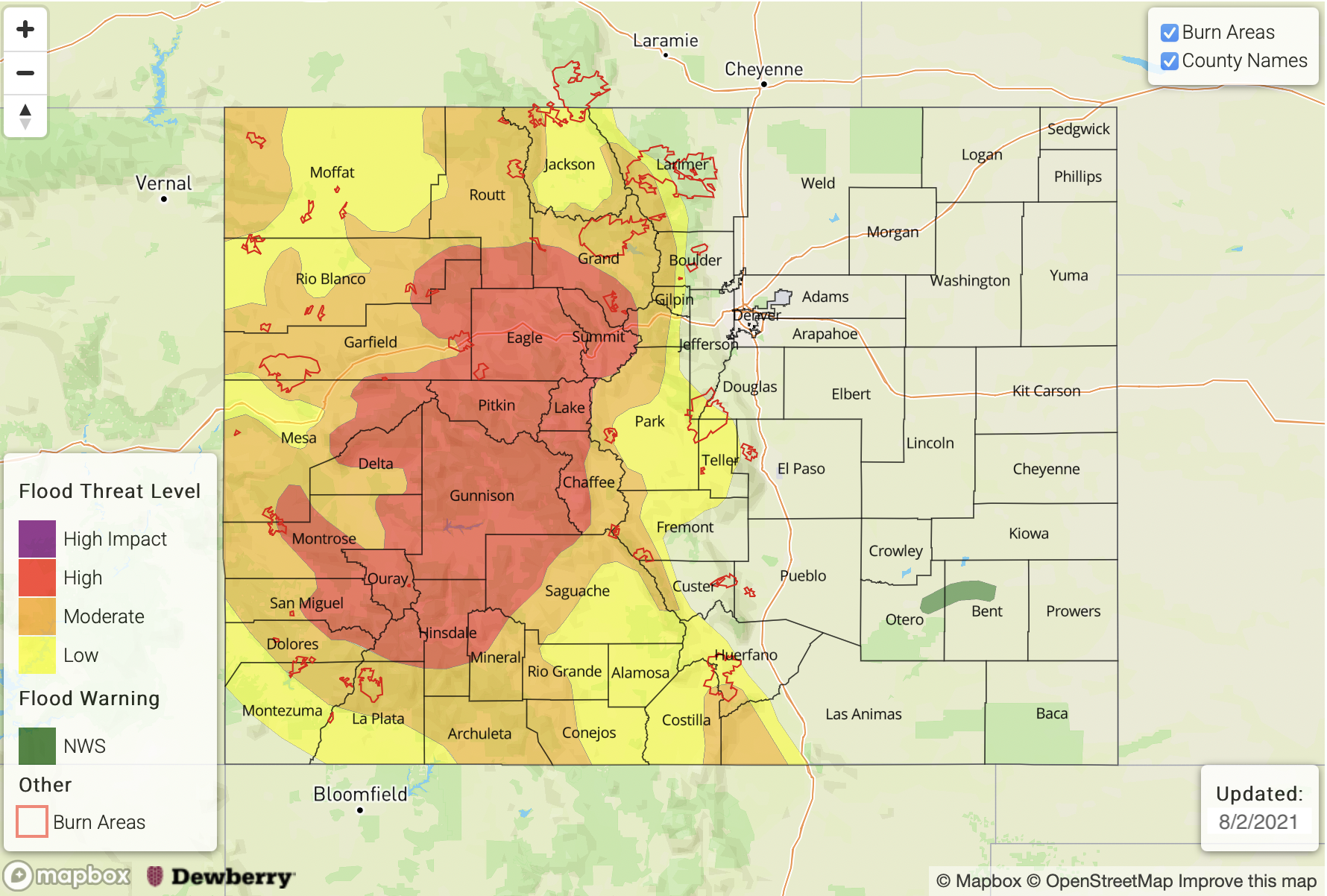
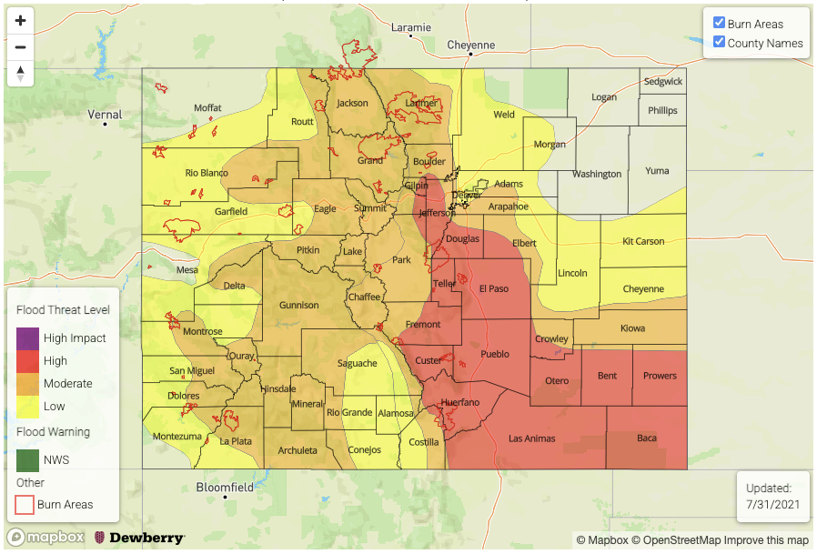
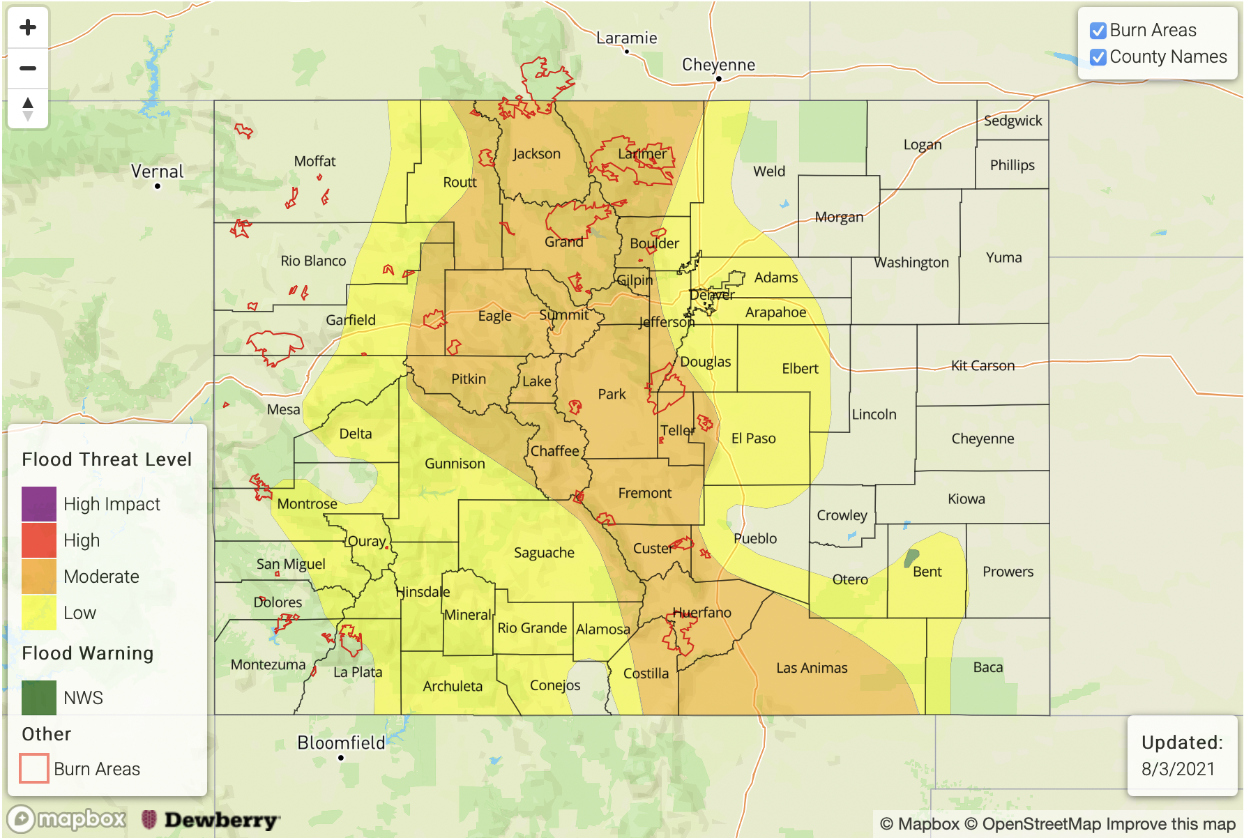
MODERATE flood threat has been issued for the Northern Mountains, Central Mountains, Front Range, Southeast Mountains, Raton Ridge and portions of the Southeast Plains
LOW flood threat has been issued for the Northwest Slope, Grand Valley, Southwest Slope, San Juan Mountains, San Luis Valley, Urban Corridor and Palmer Ridge
An NWS Flood Warning is in effect for the Purgatoire River near Las Animas

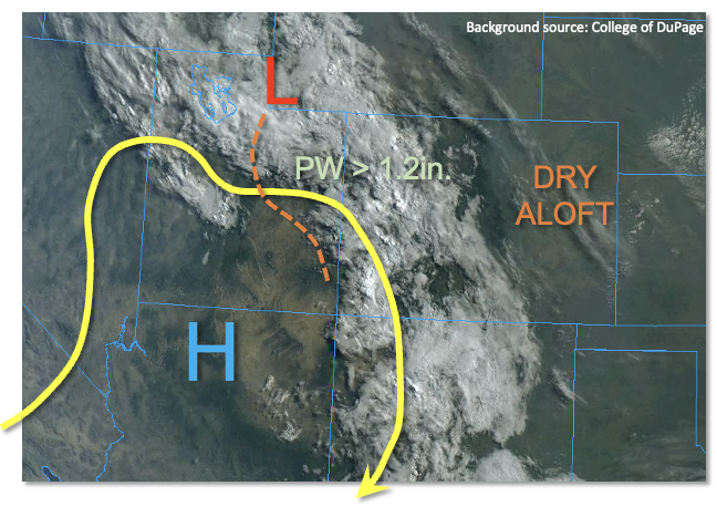
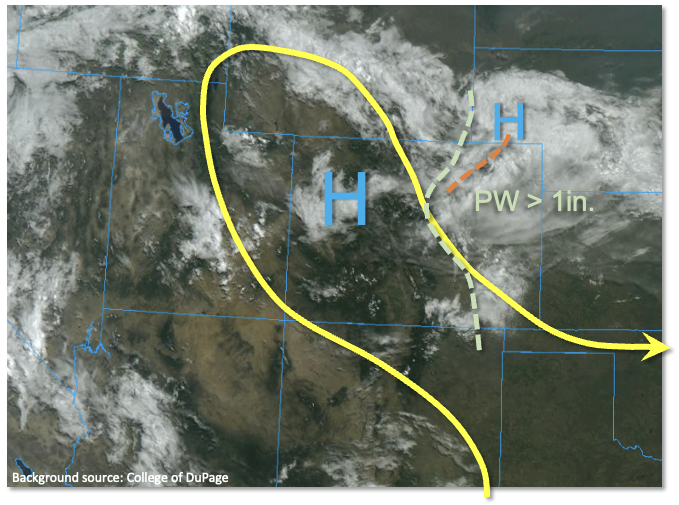
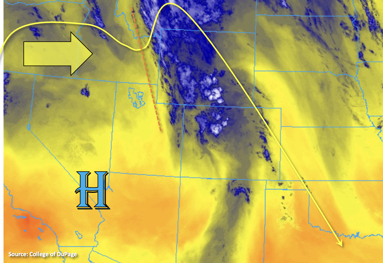
Slow, eastward progression of the trough will continue today (orange dashed line), which will help in returning the heavy rainfall threat to portions of Colorado. This morning, the mid-level lift paired with the PW plume is producing heavy cloud cover and some showers over central Colorado. As the day continues, a drier air mass behind the trough is expected to move across the western border, which will reduce the coverage of rainfall. Particularly for the lower elevations of the western border counties. However, over central Colorado and the immediate eastern adjacent plains, the incoming shortwave and associated plume of moisture (PW > 1 inch) will set the stage for some heavy downpours.

Similar to yesterday, CAPE values will reach only moderate values over the foothills and central mountains due to the ongoing cloud cover. However, with a little daytime heating, storms are expected to pick up in intensity and coverage with the diurnal flow. Slow steering flows and enhance upward motion will cause the threat to be less from the 1-hour rainfall and more in the 2-6 hour time frame. Saturated soils from the last several days of rainfall will also increase the risk for excessive runoff and mud flows/debris slides over the steeper terrains where the stronger storms can develop with better heating. For these reasons, a MODERATE flood threat has been issued.

Storms are expected spill into the adjacent plains by late this afternoon/early this evening, and best coverage of rainfall will likely be over the elevated ridges. Slightly higher instability may be able to build over these areas, especially south, which may allow for a few stronger thunderstorms to develop. Road, local stream/creek and low-lying area flooding will be possible, so a MODERATE flood threat has been issued.

Today’s Flood Threat Map

For more information on today’s flood threat, see the map below. If there is a threat, hover over the threat areas for more details, and click on burn areas to learn more about them. For Zone-Specific forecasts, scroll below the threat map.

Zone-Specific Forecasts:

Grand Valley, San Luis Valley, Northern Mountains, Northwest Slope, Southwest Slope & San Juan Mountains:

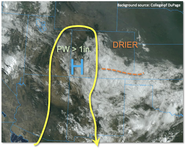
Although a drier air mass will be moving in from the west and limit the rainfall chances across the lower elevations, pockets of higher moisture will likely still exist over the elevated terrains. Clearing associated with the drying air mass will also help some decent instability to build where the moisture can hold on. Therefore, a couple isolated thunderstorms are conceivable over the elevated plateaus and mountain regions. Max 1-hour rain rates up to 1.25 along with 2-3 hour totals up to 1.75 inches will be possible. These storms could cause excessive runoff, mud flows and debris slides over already saturated soils, so for these reasons, a MODERATE/LOW flood threat has been issued.

Primetime: 11AM to 10PM

Southeast Mountains, Central Mountains, Front Range, Northeast Plains, Urban Corridor, Raton Ridge, Palmer Ridge & Southeast Plains:

There will be an uptick in storm coverage and rainfall today with the plume and trough moving eastward. Ongoing showers and cloud cover may limit the instability that can build over the Front Range/Central Mountains, but isolated 2-6 hour totals up to 3.25 inches will be possible with the moist adiabatic lapse rates. Similar totals will be possible over the Southeast Mountains. A MODERATE flood threat has been issued for excessive runoff, mud flows and debris slides.

Further south, it is possible for some better instability to build, so as storms roll off the mountains late this afternoon into this evening, a couple stronger thunderstorms may develop. Max 1-hour rain rates up to 1.75 inches will be possible over the Raton Ridge and southern Southeast Mountains. Over the Palmer Ridge and southern Urban Corridor, storm totals up to 1.75 inches will be possible. A MODERATE/LOW flood threat have been issued. Storms may linger into the overnight hours with most activity ending just after midnight.

Primetime: Ongoing to 1AM


FTB 08-02-2021: High Flood Threat For High Terrain As Disturbance Moves In

Issue Date: Monday, August 2nd, 2021
Issue Time: 9:30AM MDT

— A HIGH flood threat has been posted for parts of the Northern Mountains, Central Mountains, and San Juan Mountains
The HIGH threat persists into the late evening hours, especially for northern areas
— A MODERATE flood threat has been posted for parts of the Northwest Slope, Grand Valley, Southwest Slope, Southeast Mountains and Front Range
— A LOW flood threat has been posted for parts of the San Luis Valley
An NWS Flood Warning is in effect for the Arkansas River at La Junta and downstream areas

While the past few days’ worth of elevated flood threats has been primarily reliant on copious moisture (and high elevation heating) to drive the heavy rainfall, an important new feature today ups the ante and warrants a HIGH flood threat for the higher terrain. As shown in the visible satellite picture below, this feature is a pronounced disturbance, currently over eastern UT, that is embedded in the upper-level monsoon ridge. This disturbance will trek slowly eastward, bringing in cooling temperatures aloft, promoting a widespread tropical-like rainfall for Colorado’s entire higher terrain.

A strong moisture gradient exists this morning with Denver’s PW of 0.79 inches contrasting with Grand Junction’s 1.30 inches. For the western slope, this high of a PW is within ~10% of their record. Furthermore, Albuquerque’s PW of 1.26 inches and Salt Lake City’s 1.35 inches summarize just how expansive this monsoonal moisture plume is. An expansive cloud deck with showers and weak storms is already ongoing across the western slope, which will limit instability to ~600 J/kg or less. However, just like with Saturday’s rainfall over the Arkansas River basin, instability is essentially a useless metric today since tropical rainfall can occur with almost no instability. The presence of synoptic scale upward motion from the disturbance will be enough to cause a ~12 hour period of persistently moderate to heavy rainfall over the higher terrain, which is what warrants the HIGH threat. In addition to the threat of heavy rainfall, widespread areas have now received more than 1 inch of rain over the past week or so. Thus, there will be a particularly elevated threat of mud flows and debris slides that can respond to rainfall with very long lag times of days.

For the eastern Colorado plains, there will be a sharp gradient in the precipitation shield so that elevations below 8,000 feet are not expected to see much if any rainfall.

Today’s Flood Threat Map

For more information on today’s flood threat, see the map below. If there is a threat, hover over the threat areas for more details, and click on burn areas to learn more about them. For Zone-Specific forecasts, scroll below the threat map.

Zone-Specific Forecasts:

Northern Mountains, Central Mountains, Northwest Slope, Grand Valley, Southwest Slope, San Luis Valley, San Juan Mountains, Southeast Mountains and Front Range:

Multiple rounds of showers and thunderstorms from late morning through late evening, especially above 8,000 feet in elevation. Max 30-minute rainfall up to 0.8 inches and max 1-hour rainfall up to 1.5 inches. Over the highest terrain of central Colorado, up to 3.6 inches of rainfall is possible by tomorrow morning, supporting a HIGH flood threat for flash flooding, debris slides and mud flows. Saturated soils will contribute to this threat. Stream and creek flooding will also be possible.

For surrounding locations, a MODERATE/LOW flood threat is posted for more isolated flash flooding, debris slides and mud flows. Up to 2.6 inches of rainfall is possible by morning.

Primetime: 12PM through midnight

Palmer Ridge, Raton Ridge, Southeast Plains, Urban Corridor and Northeast Plains:

Partly cloudy with isolated showers and a few weak thunderstorms possible near the foothills. Dry conditions are expected further east. Max 1-hour rainfall up to 0.6 inches. Flooding is NOT expected today.

Primetime: 2PM through 9PM

FTB 08-01-2021: Flood Threat Remains Over Western Slope; Drier East

Issue Date: Sunday, August 1st, 2021
Issue Time: 10AM MDT

— A MODERATE flood threat has been posted for parts of the Northern Mountains, Central Mountains and San Juan Mountains
— A LOW flood threat has been posted for parts of the San Luis Valley, Northwest Slope, Grand Valley, Southwest Slope and Southeast Mountains
A NWS Flood Warning is in effect for the Arkansas River just downstream of Pueblo

Cool, drier and generally more stable conditions greeted most of eastern Colorado this morning. Denver’s PW has dropped significantly from 1.20 inches to 0.79 inches, with significant drying just above the moist, shallow boundary layer in the wake of the widespread rainfall yesterday. The remnant showers and embedded weak storms from yesterday’s impressive storm complex were still visible south of the Arkansas River. This disturbance will continue to drift south into New Mexico and should have little to no impact on our weather by late afternoon. Pockets of cloud cover will likely persist mainly east of the Continental Divide, and will help to preclude most rainfall activity. The only possible exception is the northern part of the Southeast Mountains that could see some instability re-develop in the still-strong August sun and support isolated heavy rainfall.

Along and west of the Continental Divide, the relentless 2021 monsoon will continue today. Although only moderate instability is expected, to the tune of perhaps 1,000 J/kg locally, very moist conditions will make up for this. Grand Junction morning PW of 1.19 inches is significantly above normal, with a nearly moist-adiabat sounding suggestive of efficient warm-coalescence rainfall generation today (similar to what occurred over southeast Colorado yesterday). Storm motions will be somewhat erratic and fairly slow, perhaps 10-15 mph, which could support training of storms as they interact with the circulations caused by the normal topographic heating. A MODERATE/LOW flood threat is warranted again for basically the entire western slope today as 30-60 minute periods of very heavy rainfall are likely yet again. The highest coverage will be over the higher terrain above 8,000 feet, but enough moisture exists for storms to reach the valley floors once again. Saturated soils from the recent rains will also help expedite runoff.

Today’s Flood Threat Map

For more information on today’s flood threat, see the map below. If there is a threat, hover over the threat areas for more details, and click on burn areas to learn more about them. For Zone-Specific forecasts, scroll below the threat map.

Zone-Specific Forecasts:

Southeast Mountains, Northern Mountains, Central Mountains, Northwest Slope, Grand Valley, Southwest Slope, San Luis Valley and San Juan Mountains:

Numerous to widespread showers and thunderstorms this afternoon and evening, especially above 8,000 feet in elevation. Max 30-minute rainfall up to 0.9 inches and max 1-hour rainfall up to 1.7 inches support a MODERATE/LOW flood threat for isolated flash flooding, debris slides and mud flows. Many debris slides and mud flows have been reported in previous days, and it is likely that saturated soils are contributing to the ease of generating new events.

Primetime: 12PM through 10PM

Front Range, Palmer Ridge, Raton Ridge, Southeast Plains, Urban Corridor and Northeast Plains:

Early rain showers and weak thunderstorms south of the Arkansas River, then becoming partly cloudy and continued cool with an isolated shower or storm possible along the higher terrain and foothills east of the Continental Divide. Max 1-hour rainfall up to 0.5 inches possible, but flooding is NOT expected today.

Primetime: 2PM through 9PM

FTB 07-31-2021: Widespread Heavy Rainfall, Flash Flooding and Riverine Flooding Expected Today

Issue Date: Saturday, July 31st, 2021
Issue Time: 10:30AM MDT

— A HIGH flood threat has been posted for parts of the Front Range, Urban Corridor, Palmer Ridge, Southeast Mountains, Raton Ridge and Southeast Plains
— The HIGH threat will persist through at least the early overnight hours
— A MODERATE flood threat has been posted for parts of the Northeast Plains, Northern Mountains, Central Mountains and San Juan Mountains
— A LOW flood threat has been posted for parts of the San Luis Valley, Northwest Slope, Grand Valley and Southwest Slope
— An afternoon update is possible today

On the 45th anniversary of the devastating Big Thompson floods that changed the way flood detection was done in Colorado, we are expecting a very active day of heavy rainfall and flooding across major parts of the state. In fact, all 14 of our forecast zones are under some kind of flood threat today.

Let’s start first with the most vulnerable areas, which will be the I-25 corridor south of Denver through the New Mexico border as well as southeast Colorado. A cold front raced through the state overnight, bringing down high temperatures from the recent heat wave. In fact, this will mean instability will not be all that impressive today anywhere in the state, with perhaps up to 1,500 J/kg at most expected in the Southeast Plains. However, the lack of instability will be easily overcome by very high moisture content through the entire atmosphere. Denver’s PW came in at 1.20 inches today, significantly above normal for the date. Up to 1.5 inches of PW is currently estimated in eastern Colorado and this plume of moisture will move southward today after the cold front passage. A decaying mesoscale storm complex, with a distinct anti-cyclonic circulation aloft, was noted along the northeast CO border. The main impact of this will be to limit instability over the I-76 corridor, likely suppressing heavy rainfall activity. Further south and west, enough breaks in the clouds today will support moist adiabat type soundings with extremely efficient rainfall generation expected. With the sheer amount of moisture available, we expect multiple rounds of heavy rainfall along the entire high terrain east of the Continental Divide. Storms will then spill over into the foothills and Southeast Plains by later in the afternoon and persist well into the overnight hours towards the OK/KS border. In particular, the threat today is not so much from short-term 1-hour rainfall but more so the 3-6 hour timeframe where multiple heavy rainfall cores could support up to 4-7 inches of rainfall over parts of the Palmer Ridge, Southeast Mountains, Raton Ridge and Southeast Plains. With the spatial extent of heavy rainfall, in addition to the normal threat of flash flooding, riverine flooding of creeks and streams will be likely today. Base flows on the larger rivers are not all the high, mitigating any large-scale riverine flooding. However, there is a chance of a flood wave, albeit brief, along the Arkansas River this evening and overnight.

Moving west of the Continental Divide, moisture has come down somewhat over the past days, especially over the far western areas. Furthermore, instability will be lower today. Nonetheless, with plenty of moisture and strong heating expected, storms capable of heavy rainfall are expected today mainly over the higher terrain. The primary threats will be isolated flash flooding, debris slides and mud flows, just like with past days.

Today’s Flood Threat Map

For more information on today’s flood threat, see the map below. If there is a threat, hover over the threat areas for more details, and click on burn areas to learn more about them. For Zone-Specific forecasts, scroll below the threat map.

Zone-Specific Forecasts:

Front Range, Palmer Ridge, Raton Ridge, Southeast Mountains and Southeast Plains:

Widespread showers and thunderstorms expected beginning this afternoon and lasting into the overnight hours over the Southeast Plains. Max 1-hour rainfall up to 4.0 inches over the Southeast Plains and up to 3.0 inches elsewhere. Max 6-hour rainfall up to 7.0 inches over the Southeast Plains and 5.0 inches elsewhere. A HIGH flood threat has been posted for large parts of the area for flash flooding, debris slides and mud flows over the steeper terrain as well as creek and stream flooding especially later into the evening as runoff begins to channel into the flood plains.

Primetime: 3PM through 5AM (Southeast Plains)
Primetime: 12PM through midnight (outside of Southeast Plains)

Urban Corridor, Northeast Plains:

Much cooler with scattered to numerous showers and thunderstorms this afternoon and evening, especially closer to the foothills. Max 1-hour rainfall up to 2.9 inches and max 3-hour rainfall up to 4.0 inches supports a MODERATE/LOW flood threat for isolated flash flooding. Creeks and smaller streams could experience minor flooding in areas with the more persistent heavy rainfall.

Primetime: 1PM through 11PM

Northern Mountains, Central Mountains, Northwest Slope, Grand Valley, Southwest Slope, San Luis Valley and San Juan Mountains:

Scattered with numerous showers and thunderstorms expected this afternoon and evening. Highest coverage will be over the foothills and higher elevations right along the Continental Divide. Max 1-hour rainfall up to 1.6 inches supports a MODERATE/LOW flood threat for isolated flash flooding, debris slides and mud flows.

Primetime: 12PM through 10PM