SPM 10-01-2022: Heavy Precipitation for Northwest Half of State

Issue Date: Saturday, October 1, 2022
Issue Time: 9:45 AM MDT

Summary:

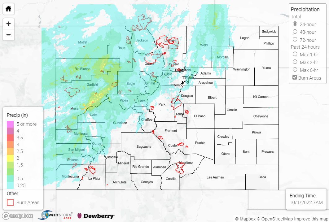
All good things must come to an end, but we sure had an active day of weather for the last SPM post of the 2022 season. Thanks to a cut-off upper-level low spinning over the northern Great Basin, scattered showers and storms overspread much of the northwestern half of the state on Friday. The heaviest rain was observed along and northwest of a line from roughly Durango to Sterling, while the southeastern half of the state remained largely dry.

Amounts of 0.25-0.75” were fairly commonplace where precipitation was observed, with locally higher amounts of 1-2+”. Stronger storms were observed along the western I-70 corridor near Grand Junction, prompting two Severe Thunderstorm Warnings and two Flood Advisories. No flooding was reported, but 0.25” hail was reported in Grand Junction. Mammatus clouds were even observed:

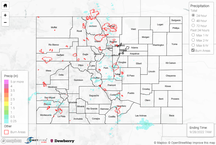
Notable rainfall totals include the following:

• 2.80” near Paonia State Park
• 2.26”, 2.15”, and 1.81” east of Glenwood Springs
• 1.42” near Grand Mesa
• 1.16”, 1.10”, and 1.02” near Grand Junction
• 1.13” east of New Castle
• 0.98” southeast of Rifle

Some of the highest mountain elevations (10,000+ feet) experienced their precipitation in the form of snowfall yesterday:

Several USGS gauges in the Central and Northern Mountains are running at all-time highs for this day of the year thanks to yesterday’s rain, but no flooding was reported. For precipitation estimates in our area, check out the map below. Remember, if you observe flooding in your area, you can use the “Report a Flood” page to make a flood report when you can safely do so.

As alluded to above, this will be the last SPM post until next season. It has been a pleasure providing these daily posts for the state of Colorado throughout the 2022 flood season.

Click Here For Map Overview

The map below shows radar-estimated, rainfall gage-adjusted Quantitative Precipitation Estimates (QPE) across Colorado. The map is updated daily during the operational season (May 1 – Sep 30) by 11AM. The following six layers are currently available: 24-hour, 48-hour and 72-hour total precipitation, as well as maximum 1-hour, 2-hour and 6-hour precipitation over the past 24 hour period (to estimate where flash flooding may have occurred). The accumulation ending time is 7AM of the date shown in the bottom right corner. Also shown optionally are vulnerable fire burn areas (post 2012), which are updated throughout the season to include new, vulnerable burn areas. The home button in the top left corner resets the map to the original zoom.

SPM 09-30-2022: Rain for Northwestern Portions of State

Issue Date: Friday, September 30th, 2022
Issue Time: 10:15 AM MDT

Summary:

High elevation showers and storms developed by early afternoon on Thursday, with the heaviest precipitation falling over northwestern portions of the state roughly along and west of I-25 and along and north of I-70. In this region, QPE data and rain gauge observations suggest that amounts up to 0.50” were observed under the most intense cells. Notable rain gauge observations include:

• 0.45” near Trappers Lake
• 0.44” near Glenwood Springs
• 0.40” north of Glenwood Springs
• 0.33” near Kremmling

QPE data suggests isolated lighter amounts of 0.25” or less across portions of the San Juans, southern Front Range/Urban Corridor, Palmer Ridge, Northeast Plains, and Southeast Mountains.

Looking at the U.S. Drought Monitor updated yesterday morning, we see a further reduction in moderate, severe, and extreme drought conditions (by percent area) across the state compared to last week, while the percent area of exceptional drought conditions remained unchanged.

No flooding was reported yesterday. For precipitation estimates in our area, check out the map below. Remember, if you observe flooding in your area, you can use the “Report a Flood” page to make a flood report when you can safely do so.

Click Here For Map Overview

The map below shows radar-estimated, rainfall gage-adjusted Quantitative Precipitation Estimates (QPE) across Colorado. The map is updated daily during the operational season (May 1 – Sep 30) by 11AM. The following six layers are currently available: 24-hour, 48-hour and 72-hour total precipitation, as well as maximum 1-hour, 2-hour and 6-hour precipitation over the past 24 hour period (to estimate where flash flooding may have occurred). The accumulation ending time is 7AM of the date shown in the bottom right corner. Also shown optionally are vulnerable fire burn areas (post 2012), which are updated throughout the season to include new, vulnerable burn areas. The home button in the top left corner resets the map to the original zoom.

SPM 09-29-2022: More Showers and Storms for High Terrain South of I-70

Issue Date: Thursday, September 29th, 2022
Issue Time: 11:00 AM MDT

Summary:

Despite a decrease in moisture and slight warming aloft, isolated showers and storms were again able to develop over the highest terrain, mainly along and south of Interstate 70. Precipitation totals were generally light, with amounts of 0.35” or less. Farther north, light totals of generally 0.10” or less were observed across portions of the Northwest Slope.

No flooding was reported yesterday. For precipitation estimates in our area, check out the map below. Remember, if you observe flooding in your area, you can use the “Report a Flood” page to make a flood report when you can safely do so.

Click Here For Map Overview

The map below shows radar-estimated, rainfall gage-adjusted Quantitative Precipitation Estimates (QPE) across Colorado. The map is updated daily during the operational season (May 1 – Sep 30) by 11AM. The following six layers are currently available: 24-hour, 48-hour and 72-hour total precipitation, as well as maximum 1-hour, 2-hour and 6-hour precipitation over the past 24 hour period (to estimate where flash flooding may have occurred). The accumulation ending time is 7AM of the date shown in the bottom right corner. Also shown optionally are vulnerable fire burn areas (post 2012), which are updated throughout the season to include new, vulnerable burn areas. The home button in the top left corner resets the map to the original zoom.

SPM 09-28-2022: Increased Showers and Storms for High Terrain

Issue Date: Wednesday, September 28th, 2022
Issue Time: 11:10 AM MDT

Summary:

A further increase in moisture resulted in increased shower and storm coverage for a broader swath of high terrain on Tuesday. The heaviest rainfall amounts were observed over the mountains of the Front Range and southward into the Southeast Mountains, where amounts up to 0.50” are indicated by QPE data. Notable rain gauge observations include:

• 0.43” near San Isabel
• 0.41” west of Colorado Springs
• 0.29” near Estes Park
• 0.23” near Guffrey

Across the San Juans, amounts were lighter with generally 0.25” or less; the highest observations were across the southern San Juans, particularly in the vicinity of Pagosa Springs. Elsewhere across the state, most locations remained dry with pleasant weather.

No flooding was reported yesterday. For precipitation estimates in our area, check out the map below. Remember, if you observe flooding in your area, you can use the “Report a Flood” page to make a flood report when you can safely do so.

Click Here For Map Overview

The map below shows radar-estimated, rainfall gage-adjusted Quantitative Precipitation Estimates (QPE) across Colorado. The map is updated daily during the operational season (May 1 – Sep 30) by 11AM. The following six layers are currently available: 24-hour, 48-hour and 72-hour total precipitation, as well as maximum 1-hour, 2-hour and 6-hour precipitation over the past 24 hour period (to estimate where flash flooding may have occurred). The accumulation ending time is 7AM of the date shown in the bottom right corner. Also shown optionally are vulnerable fire burn areas (post 2012), which are updated throughout the season to include new, vulnerable burn areas. The home button in the top left corner resets the map to the original zoom.