FTO 09-29-2022: Unsettled Weather Pattern Heading Into The Weekend

Issue Date: Thursday, September 29th, 2022
Issue Time: 1:30PM MDT
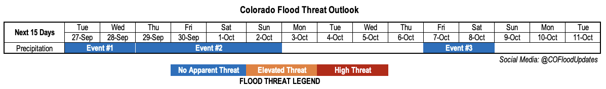
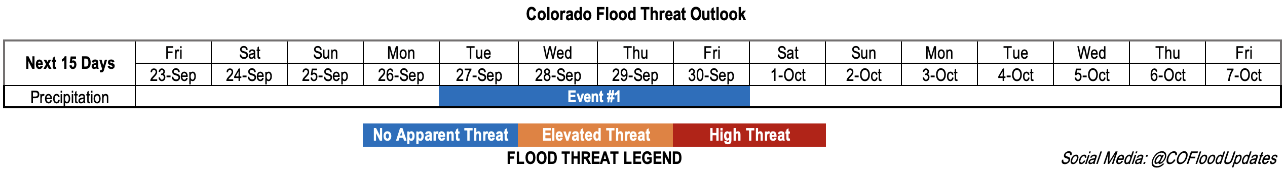
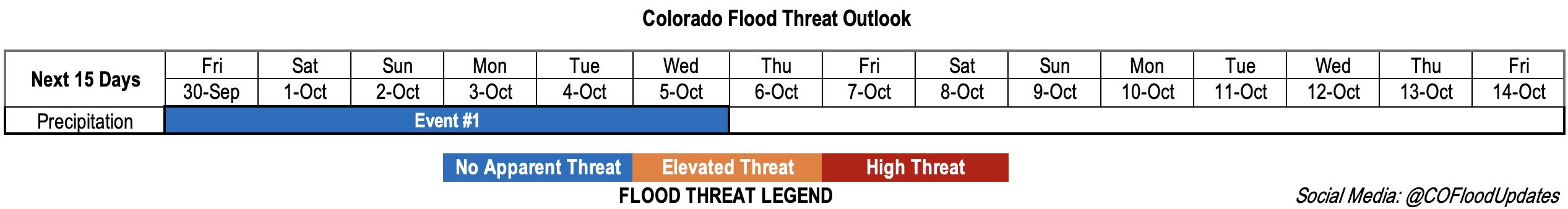
Valid Dates: 9/30 – 10/14

Note: This is the final Flood Threat Outlook of the 2022 forecast season, but the program is scheduled to return on May 1, 2023. It has been our pleasure serving the state of Colorado for another flood season!

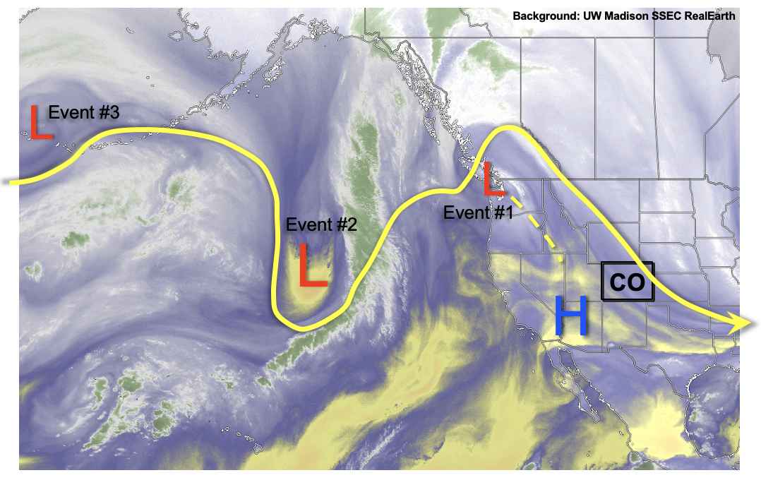
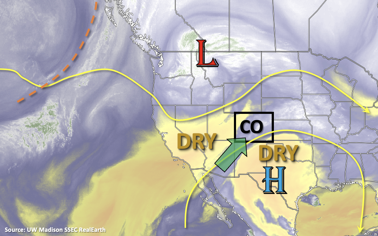
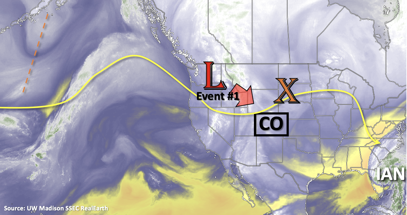
Event #2 from Monday’s FTO has become the main event for this final outlook period. As the Low, marked in the water vapor imagery below, becomes cut off from the steering flow, it is expected to linger north of the state for a handful of days. With plenty of upper and mid-level dynamics accompanying the Low and decent moisture in place over the state, scattered to numerous storms are anticipated for the mountains and portions of the plains through next week. Heading into next week, it looks like the Low should start to break up with increasing northwesterly flow aloft forecast. It’s likely that a cold front will drop through the state on the backside of what remains of the Low sometime between Sunday and Tuesday, which could bring some more intense rainfall to plains. Following this event, a warmer and calmer period is anticipated.

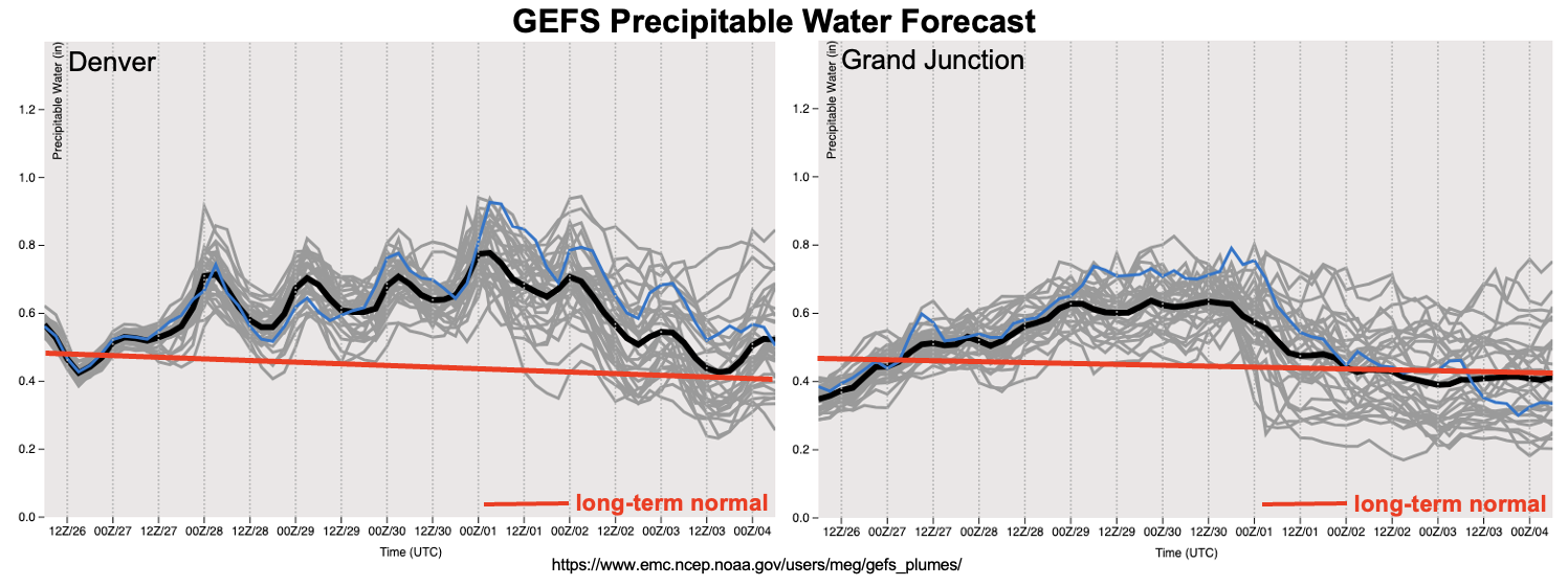
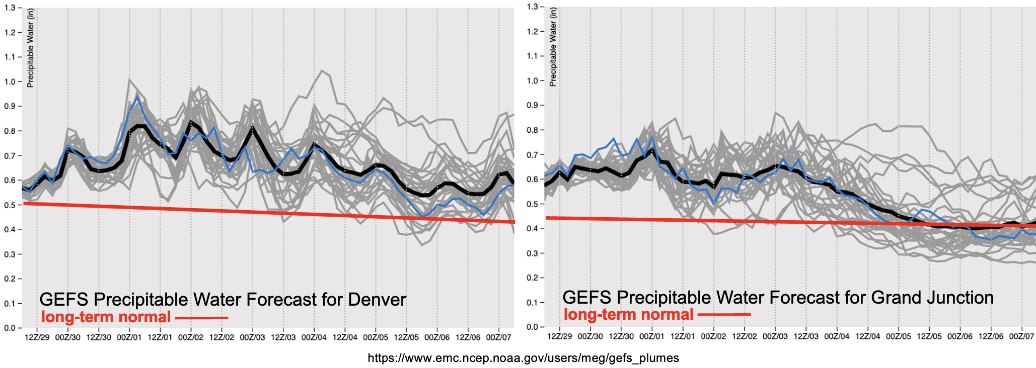
Heading into October, average PW values start to take a nosedive, which helps reduce the heavy rainfall threat amid other factors. During Event #1, above average values PW values are likely to occur both east and west, but with values remaining well below an inch, heavy rainfall is not anticipated at this time. While there may be some isolated, weak thunderstorms that can develop during the afternoon and evening hours, surface moisture, especially on the front-end of this system, should be limited. This should help to keep rainfall rates in the light to moderate range. Generally speaking, longer duration, stratiform precipitation is mostly forecast during this event, which should also help to reduce the flood threat. It is increasingly likely that snow will develop across the highest elevations (mostly above 9,500 feet), especially with any overnight precipitation that lingers over the mountains.

As far as temperature, afternoon highs should be quite enjoyable and fall-like with overnight temperatures becoming quite chilly, especially in areas that are cloud-free. So, prepare for the classic fall Colorado diurnal temperature swings. Scroll down to view more details about the event outlined in today’s FTO.
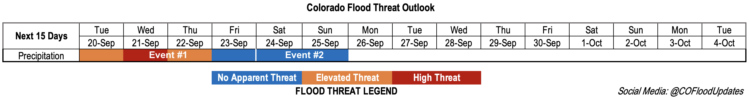
Event #1: FridayWednesday (9/3010/5)

No Apparent flood threat as an incoming Low becomes cut off and helps boost the chance for precipitation through next week.

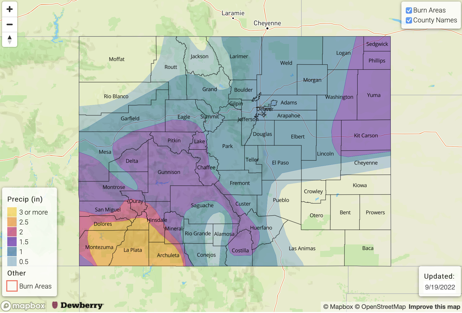
With scattered to numerous storms forecast during Event #1, highest precipitation accumulations are anticipated over the mountains. Initially, storms are expected to develop over northwestern and northern Colorado on Friday, but with cooler temperatures, little to no CAPE is expected. So, rainfall should be stratiform with perhaps some embedded convection. By Sunday, the majority of rainfall should be over the central and southern high terrain. Again, with limited CAPE, the heavy rainfall threat remains on the lower end with max 3-6 hour totals up to 1.25 inches possible. A cold front is expected to drop through eastern Colorado sometime between Sunday and Tuesday, which may help produce some rainfall over the plains and expand mountain precipitation. Portions of the plains may be able to pick up an inch of rain along and near the front over a 1 to 3-hour period, and a couple thunderstorms may be able to develop depending on the timing of the frontal passage. All in all, there is a limited chance of flooding with cooler temperatures over the state with ongoing rainfall, so there is No Apparent flood threat issued. We’ll be sure to keep an eye on the system and produce a special off-season FTB forecast if necessary, but at this time, it is unlikely that one will be needed.

FTO 09-26-2022: Welcome Autumn Rain (And Snow) On The Way

Issue Date: Monday, September 26th, 2022
Issue Time: 12:30 MDT
Valid Dates: 9/27 – 10/11

If there has been one central theme about Colorado autumn’s over the past few years, it is the incredibly active wildfire seasons. And the anxiety that comes with knowing that it is possible. Late September marks a transition point from monsoonal, convective dynamics to synoptic-scale dynamics as the mid-latitude jet stream strengthens and moves south. In years with a weak monsoon, this leaves a longer, vulnerable period of time where very dry conditions can exist. Fortunately, this year had anything but a weak monsoon. As shown below for a high-elevation SNOTEL site, about 7 inches of precipitation deficit was erased over the course of the monsoon season at this location! This kind of surplus extended across large portions of southern and western Colorado. And even more fortunately, we continue to see fairly active weather over the period of this Outlook that should keep the drought threat at bay.

As seen in the water vapor image, below, a weak upper-level ridge currently over the Four Corners will be replaced by a series of disturbances strung out across the entire North Pacific Ocean. (As an aside, it is refreshing to be able to forecast further in time now that the monsoon season is winding down!) The first, rather weak disturbance will race across the state Tuesday and Wednesday causing an increase in mainly higher elevations showers and weaker storms (Event #1). By Thursday, a stronger disturbance will enter the North American coast and likely cut off from the main steering flow. This will allow for a 48-96 hour period of active weather, depending on how quickly the disturbance will traverse the northern Rockies (cut-off motion is notoriously difficult to predict).

As shown in the GEFS PW plumes, below, Event #2 will be accompanied by above normal moisture statewide but especially over northern Colorado. With PW exceeding 0.75 inches, we expect scattered to numerous coverage of showers and weaker storms. Although highly unlikely, the only possibility of a (low-end) flood threat could be over the far eastern Plains where convective instability and slow moving dynamics may juxtapose for a multi-hour period over heavy rainfall by Saturday or Sunday. But at this time, we reiterate that this looks very unlikely. Regardless, a widespread soaking rain is anticipated for the northern two-thirds of the state, which is excellent news for replenishing soil moisture as we head into the dry season. Some snow is also expected beginning Friday, and through Sunday, although the snow level should remain very high, above 10,000 feet.

After Event #2, seasonably warm fall weather is expected to return by next week with warm days and cool nights. Another increase in rainfall looks possible by later next week as the next Pacific disturbance comes in, along with some subtropical contribution. However, flooding is not expected with this event.

The identified precipitation events are described in more detail below.

Event #1: Tuesday – Wednesday (September 27 – September 28)

Showers And Weak Storms Expected Mainly Over Higher Terrain; No Apparent Flood Threat

Moisture will slowly rebound from the current dry levels and widely scattered showers and storms will reappear over mainly the central and southern high terrain on Tuesday and Wednesday afternoon. Max 30-min rain rates up to 0.4 inches possible, and flooding is NOT expected.

Event #2: Thursday – Sunday (September 29 – October 2)

Widespread Soaking Rain Expected; No Apparent Flood Threat

More active weather will begin on Thursday, with scattered higher terrain showers and storms. By Friday and Saturday, widespread rain and snow showers, with some embedded rumbles of thunder, are expected over mainly the northern and central higher terrain. Max 3-6 hour rainfall up to 1.0 inch is possible, but flooding is NOT expected. On Saturday and Sunday, there is a chance of higher rain intensity over the lower elevations of eastern Colorado. Max 1-hour rainfall up to 1.0 inch is possible, but is well below flood threat thresholds over that terrain.
Overall, widespread rainfall amounts of 0.5 – 1.25 inches are expected over northern and central Colorado by late Sunday.

Event #3: Friday – Saturday (October 7 – October 8)

An Increase In Rain Chances Possible; No Apparent Flood Threat

Another disturbance from the Pacific Ocean will bring in an increase in moisture and greater rain chances. At this time, precipitation is expected to remain below 0.5 inches, so a precipitation map is not provided.

FTO 09-22-2022: Dry Trend & Warming Temperatures Heading Into The Weekend

Issue Date: Thursday, September 22nd, 2022
Issue Time: 2:20PM MDT
Valid Dates: 9/23 – 10/7

It looks like the active monsoon season will finally come to an end after today’s rainfall. After the Low to our northwest moves eastward, dry westerly and northwesterly flow aloft is expected to develop over the state. This should help to scour out any remaining moisture, and thus reduce the chance of precipitation heading into this weekend. Additionally, building High pressure should promote subsidence along with warming temperatures. There is a slight cool down forecast across the lower elevations of eastern Colorado on Sunday. There is also better model agreement that the weak cool front on Saturday will be lacking moisture, so a dry frontal passage is anticipated. The cooldown should only be a brief with temperatures returning to 3°F to 8°F above average by early next week.

Some vorticity is expected to pinch off of the trough shown in the water vapor imagery below (orange dashed line) over the next couple of days. Then another incoming trough is expected to push that mid-level lift under the ridging pattern next week. This should support a slight increase moisture over the state and aid in the return afternoon and evening storms to the forecast by mid-week (Event #1).

Although the plumes below are from Wednesday night’s GEFS run, you can see the model consensus regarding the quick drop off in PW values behind the Low. The narrow stream of subtropical moisture (green arrow, above) is expected to be cut off and dry air (yellow and orange shades, above) should fill in over the state. With this dry air mass helping to mix out the remaining surface moisture, and the next system only transporting in minimal moisture, rain rates are expected to remain below flood threat criteria for Event #1. For this reason, No Apparent flood threat has been issued.

Event #1: Tuesday – Friday (9/27 – 9/30)

No Apparent flood threat – Moisture and weak mid-level lift return to the area, which should cause widely scattered mountain storms to return.

Isolated to widely scattered afternoon and evening storms will return to the forecast by mid-week. The diurnally driven storms are expected to generally move west to east, and meaningful accumulation should stick to the mountains. Max 30-minute rain rates up to 0.5 inches will be possible over the central and south high terrain, so outside of some localized runoff, flooding is not expected. Models are still having some differences around timing, but it looks like there will be a peak in storm coverage either on Wednesday or Thursday. Be sure to tune into Monday’s FTO for the latest.

FTO 09-19-2022: The Late Season Monsoon Event Begins

Issue Date: Monday, September 19th, 2022
Issue Time: 3PM MDT
Valid Dates: 9/20 – 10/4

An active rainfall pattern is forecast to start this week with a subtropical moisture plume arriving to Colorado by tomorrow morning. As moisture from Tropical Cyclone Madeline moves northwards, it will be picked up and pulled into the state by the southwest flow created from the cutoff Low off the coast of California and High pressure center over Texas/Oklahoma (Event #1). Embedded in this plume will likely be some small disturbances causing extra lift, which could help produce some localized convection. Additionally, a trough to our north is expected to track eastward, which will drop a cold front through the state late on Tuesday into Wednesday morning ending the late season hot streak. This also may mean that portions of the eastern plains get wet on Wednesday and Thursday. Enhanced convergence along a developing surface boundary is expected to help increase rainfall totals and rainfall rates over the state with a peak in storm activity forecast for Wednesday. By Friday morning, the cutoff Low should be north of the state and lift from it will continue to track eastward. Behind the Low, dry westerly flow is expected to take over, which should aid in quickly reducing the chance for precipitation on Friday.

Event #2 will likely begin on Saturday evening and last through Sunday midday when another cold front is forecast to drop through the state. There are still a few differences between models and individual runs for this event, but currently, more stratiform rainfall is forecast for the eastern plains. For this reason, there is No Apparent threat issued at this time.

Once the moisture plume for Event #1 is overhead, the GEFS suggests that PW will be running near the maximum moving average or slightly above for late September. That translates to PW values around or just above 1 inch, which is highly correlated to chase for heavy rainfall. While there may be some stronger storms that develop during the afternoons in areas that receive some breaks in cloud cover, the real threat for Event #1 will be from the longer duration rainfall and excessive runoff. Highest total for the event are anticipated to be over the southwest high terrain, but totals over 1.5 inches could also occur over portions of the west-central high terrain. A low-end High flood threat has been issued on Wednesday with an Elevated flood threat issued for both Tuesday and Wednesday.

Scroll down to read more about the two events highlighted in today’s FTO.

Event #1: TuesdayFriday (9/20 – 9/23)

Late season monsoon surge to cause heavy rainfall over the central and south portions of western Colorado; High flood threat issued.

On Tuesday, scattered storms should mostly be located over the central and south high terrain of western Colorado. With drier low-levels and the likely limited instability, rain rates should only to be of moderate intensity. However, training storms may push localized 3-hour totals close to 1.75 inches. For this reason, a low-end Elevated flood threat has been issued. Heading into Wednesday, more widespread rainfall is forecast for central and southwest Colorado where moisture and dynamics will be maximized. Isolated 3-hour rain rates up to 2.25 inches and 24-hour totals up to 3 inches may be possible, so a High flood threat has been issued. By Thursday, max 3-hour rain rates will likely fall between 1 and 1.5 inches, but saturated soils will likely cause excessive runoff. For this reason, an Elevated flood threat has been issued. Rises in local streams, creeks and rivers should be anticipated over the next few days as well as ponding in low-lying areas. Over steeper terrain, isolated mud flows and debris slides may be possible. As far as storm totals, about 30% of the EPS members (50 total) are suggesting totals at or exceeding 3 inches in Durango, so it’s going to get wet. Not surprisingly, NWS Grand Junction issued a Flood Watch earlier today. Be sure to tune into the daily FTB for the latest details and daily flood forecast.

Event #2: SaturdaySunday (9/24 – 9/25)

It looks like another cold front may drop through the state during this period, but there is No Apparent flood threat issued.

Currently guidance is predicting this cold front to move through Saturday night into Sunday morning. With limited instability during the overnight hours, only stratiform, scattered storms are expected for the eastern plains. Rain rates should remain under 0.5 inches per hour, so no precipitation map has been drawn.