Issue Date: Monday, September 26th, 2022
Issue Time: 12:30 MDT
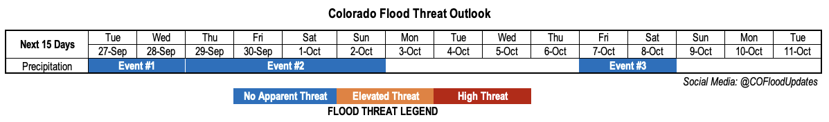
Valid Dates: 9/27 – 10/11
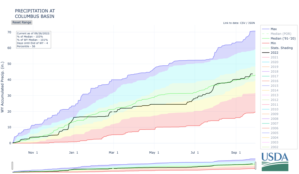
If there has been one central theme about Colorado autumn’s over the past few years, it is the incredibly active wildfire seasons. And the anxiety that comes with knowing that it is possible. Late September marks a transition point from monsoonal, convective dynamics to synoptic-scale dynamics as the mid-latitude jet stream strengthens and moves south. In years with a weak monsoon, this leaves a longer, vulnerable period of time where very dry conditions can exist. Fortunately, this year had anything but a weak monsoon. As shown below for a high-elevation SNOTEL site, about 7 inches of precipitation deficit was erased over the course of the monsoon season at this location! This kind of surplus extended across large portions of southern and western Colorado. And even more fortunately, we continue to see fairly active weather over the period of this Outlook that should keep the drought threat at bay.
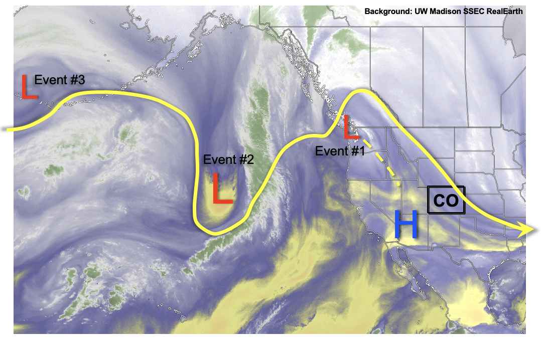
As seen in the water vapor image, below, a weak upper-level ridge currently over the Four Corners will be replaced by a series of disturbances strung out across the entire North Pacific Ocean. (As an aside, it is refreshing to be able to forecast further in time now that the monsoon season is winding down!) The first, rather weak disturbance will race across the state Tuesday and Wednesday causing an increase in mainly higher elevations showers and weaker storms (Event #1). By Thursday, a stronger disturbance will enter the North American coast and likely cut off from the main steering flow. This will allow for a 48-96 hour period of active weather, depending on how quickly the disturbance will traverse the northern Rockies (cut-off motion is notoriously difficult to predict).
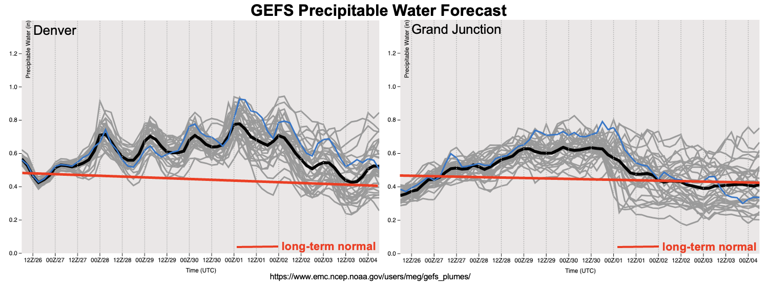
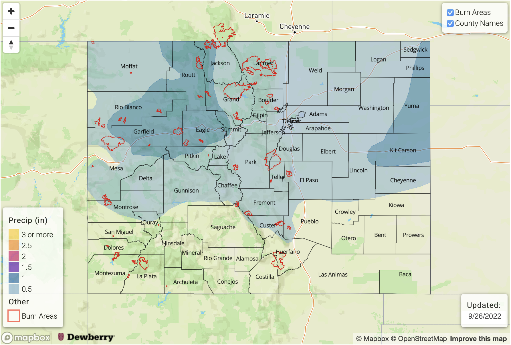
As shown in the GEFS PW plumes, below, Event #2 will be accompanied by above normal moisture statewide but especially over northern Colorado. With PW exceeding 0.75 inches, we expect scattered to numerous coverage of showers and weaker storms. Although highly unlikely, the only possibility of a (low-end) flood threat could be over the far eastern Plains where convective instability and slow moving dynamics may juxtapose for a multi-hour period over heavy rainfall by Saturday or Sunday. But at this time, we reiterate that this looks very unlikely. Regardless, a widespread soaking rain is anticipated for the northern two-thirds of the state, which is excellent news for replenishing soil moisture as we head into the dry season. Some snow is also expected beginning Friday, and through Sunday, although the snow level should remain very high, above 10,000 feet.
After Event #2, seasonably warm fall weather is expected to return by next week with warm days and cool nights. Another increase in rainfall looks possible by later next week as the next Pacific disturbance comes in, along with some subtropical contribution. However, flooding is not expected with this event.
The identified precipitation events are described in more detail below.
Event #1: Tuesday – Wednesday (September 27 – September 28)
Showers And Weak Storms Expected Mainly Over Higher Terrain; No Apparent Flood Threat
Moisture will slowly rebound from the current dry levels and widely scattered showers and storms will reappear over mainly the central and southern high terrain on Tuesday and Wednesday afternoon. Max 30-min rain rates up to 0.4 inches possible, and flooding is NOT expected.
Event #2: Thursday – Sunday (September 29 – October 2)
Widespread Soaking Rain Expected; No Apparent Flood Threat
More active weather will begin on Thursday, with scattered higher terrain showers and storms. By Friday and Saturday, widespread rain and snow showers, with some embedded rumbles of thunder, are expected over mainly the northern and central higher terrain. Max 3-6 hour rainfall up to 1.0 inch is possible, but flooding is NOT expected. On Saturday and Sunday, there is a chance of higher rain intensity over the lower elevations of eastern Colorado. Max 1-hour rainfall up to 1.0 inch is possible, but is well below flood threat thresholds over that terrain.
Overall, widespread rainfall amounts of 0.5 – 1.25 inches are expected over northern and central Colorado by late Sunday.
Event #3: Friday – Saturday (October 7 – October 8)
An Increase In Rain Chances Possible; No Apparent Flood Threat
Another disturbance from the Pacific Ocean will bring in an increase in moisture and greater rain chances. At this time, precipitation is expected to remain below 0.5 inches, so a precipitation map is not provided.