Issue Date: Monday, September 19th, 2022
Issue Time: 3PM MDT
Valid Dates: 9/20 – 10/4
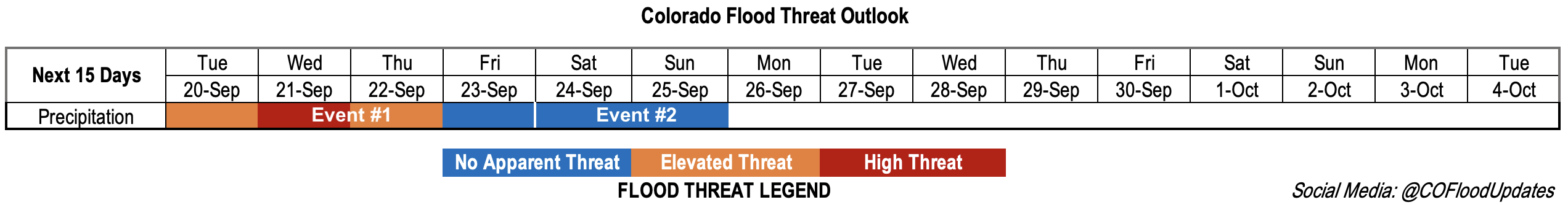
An active rainfall pattern is forecast to start this week with a subtropical moisture plume arriving to Colorado by tomorrow morning. As moisture from Tropical Cyclone Madeline moves northwards, it will be picked up and pulled into the state by the southwest flow created from the cutoff Low off the coast of California and High pressure center over Texas/Oklahoma (Event #1). Embedded in this plume will likely be some small disturbances causing extra lift, which could help produce some localized convection. Additionally, a trough to our north is expected to track eastward, which will drop a cold front through the state late on Tuesday into Wednesday morning ending the late season hot streak. This also may mean that portions of the eastern plains get wet on Wednesday and Thursday. Enhanced convergence along a developing surface boundary is expected to help increase rainfall totals and rainfall rates over the state with a peak in storm activity forecast for Wednesday. By Friday morning, the cutoff Low should be north of the state and lift from it will continue to track eastward. Behind the Low, dry westerly flow is expected to take over, which should aid in quickly reducing the chance for precipitation on Friday.
Event #2 will likely begin on Saturday evening and last through Sunday midday when another cold front is forecast to drop through the state. There are still a few differences between models and individual runs for this event, but currently, more stratiform rainfall is forecast for the eastern plains. For this reason, there is No Apparent threat issued at this time.

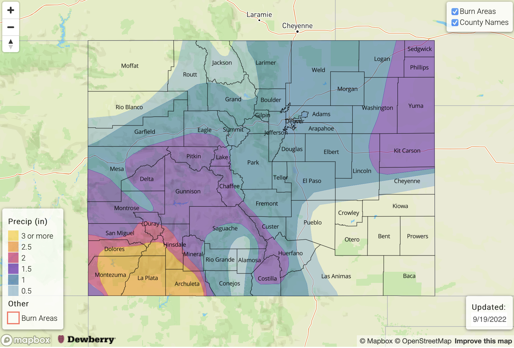
Once the moisture plume for Event #1 is overhead, the GEFS suggests that PW will be running near the maximum moving average or slightly above for late September. That translates to PW values around or just above 1 inch, which is highly correlated to chase for heavy rainfall. While there may be some stronger storms that develop during the afternoons in areas that receive some breaks in cloud cover, the real threat for Event #1 will be from the longer duration rainfall and excessive runoff. Highest total for the event are anticipated to be over the southwest high terrain, but totals over 1.5 inches could also occur over portions of the west-central high terrain. A low-end High flood threat has been issued on Wednesday with an Elevated flood threat issued for both Tuesday and Wednesday.

Scroll down to read more about the two events highlighted in today’s FTO.
Event #1: Tuesday – Friday (9/20 – 9/23)
Late season monsoon surge to cause heavy rainfall over the central and south portions of western Colorado; High flood threat issued.
On Tuesday, scattered storms should mostly be located over the central and south high terrain of western Colorado. With drier low-levels and the likely limited instability, rain rates should only to be of moderate intensity. However, training storms may push localized 3-hour totals close to 1.75 inches. For this reason, a low-end Elevated flood threat has been issued. Heading into Wednesday, more widespread rainfall is forecast for central and southwest Colorado where moisture and dynamics will be maximized. Isolated 3-hour rain rates up to 2.25 inches and 24-hour totals up to 3 inches may be possible, so a High flood threat has been issued. By Thursday, max 3-hour rain rates will likely fall between 1 and 1.5 inches, but saturated soils will likely cause excessive runoff. For this reason, an Elevated flood threat has been issued. Rises in local streams, creeks and rivers should be anticipated over the next few days as well as ponding in low-lying areas. Over steeper terrain, isolated mud flows and debris slides may be possible. As far as storm totals, about 30% of the EPS members (50 total) are suggesting totals at or exceeding 3 inches in Durango, so it’s going to get wet. Not surprisingly, NWS Grand Junction issued a Flood Watch earlier today. Be sure to tune into the daily FTB for the latest details and daily flood forecast.
Event #2: Saturday – Sunday (9/24 – 9/25)
It looks like another cold front may drop through the state during this period, but there is No Apparent flood threat issued.
Currently guidance is predicting this cold front to move through Saturday night into Sunday morning. With limited instability during the overnight hours, only stratiform, scattered storms are expected for the eastern plains. Rain rates should remain under 0.5 inches per hour, so no precipitation map has been drawn.