Issue Date: Saturday, July 31st, 2021
Issue Time: 10:30AM MDT
— A HIGH flood threat has been posted for parts of the Front Range, Urban Corridor, Palmer Ridge, Southeast Mountains, Raton Ridge and Southeast Plains
— The HIGH threat will persist through at least the early overnight hours
— A MODERATE flood threat has been posted for parts of the Northeast Plains, Northern Mountains, Central Mountains and San Juan Mountains
— A LOW flood threat has been posted for parts of the San Luis Valley, Northwest Slope, Grand Valley and Southwest Slope
— An afternoon update is possible today
On the 45th anniversary of the devastating Big Thompson floods that changed the way flood detection was done in Colorado, we are expecting a very active day of heavy rainfall and flooding across major parts of the state. In fact, all 14 of our forecast zones are under some kind of flood threat today.
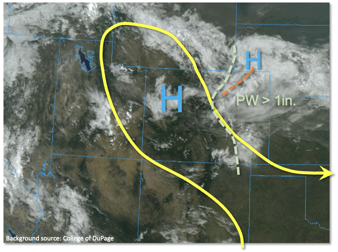
Let’s start first with the most vulnerable areas, which will be the I-25 corridor south of Denver through the New Mexico border as well as southeast Colorado. A cold front raced through the state overnight, bringing down high temperatures from the recent heat wave. In fact, this will mean instability will not be all that impressive today anywhere in the state, with perhaps up to 1,500 J/kg at most expected in the Southeast Plains. However, the lack of instability will be easily overcome by very high moisture content through the entire atmosphere. Denver’s PW came in at 1.20 inches today, significantly above normal for the date. Up to 1.5 inches of PW is currently estimated in eastern Colorado and this plume of moisture will move southward today after the cold front passage. A decaying mesoscale storm complex, with a distinct anti-cyclonic circulation aloft, was noted along the northeast CO border. The main impact of this will be to limit instability over the I-76 corridor, likely suppressing heavy rainfall activity. Further south and west, enough breaks in the clouds today will support moist adiabat type soundings with extremely efficient rainfall generation expected. With the sheer amount of moisture available, we expect multiple rounds of heavy rainfall along the entire high terrain east of the Continental Divide. Storms will then spill over into the foothills and Southeast Plains by later in the afternoon and persist well into the overnight hours towards the OK/KS border. In particular, the threat today is not so much from short-term 1-hour rainfall but more so the 3-6 hour timeframe where multiple heavy rainfall cores could support up to 4-7 inches of rainfall over parts of the Palmer Ridge, Southeast Mountains, Raton Ridge and Southeast Plains. With the spatial extent of heavy rainfall, in addition to the normal threat of flash flooding, riverine flooding of creeks and streams will be likely today. Base flows on the larger rivers are not all the high, mitigating any large-scale riverine flooding. However, there is a chance of a flood wave, albeit brief, along the Arkansas River this evening and overnight.
Moving west of the Continental Divide, moisture has come down somewhat over the past days, especially over the far western areas. Furthermore, instability will be lower today. Nonetheless, with plenty of moisture and strong heating expected, storms capable of heavy rainfall are expected today mainly over the higher terrain. The primary threats will be isolated flash flooding, debris slides and mud flows, just like with past days.
Today’s Flood Threat Map
For more information on today’s flood threat, see the map below. If there is a threat, hover over the threat areas for more details, and click on burn areas to learn more about them. For Zone-Specific forecasts, scroll below the threat map.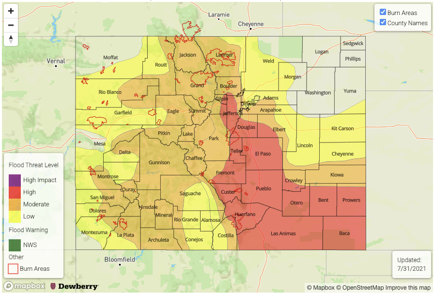
Zone-Specific Forecasts:
Front Range, Palmer Ridge, Raton Ridge, Southeast Mountains and Southeast Plains:
Widespread showers and thunderstorms expected beginning this afternoon and lasting into the overnight hours over the Southeast Plains. Max 1-hour rainfall up to 4.0 inches over the Southeast Plains and up to 3.0 inches elsewhere. Max 6-hour rainfall up to 7.0 inches over the Southeast Plains and 5.0 inches elsewhere. A HIGH flood threat has been posted for large parts of the area for flash flooding, debris slides and mud flows over the steeper terrain as well as creek and stream flooding especially later into the evening as runoff begins to channel into the flood plains.
Primetime: 3PM through 5AM (Southeast Plains)
Primetime: 12PM through midnight (outside of Southeast Plains)
Urban Corridor, Northeast Plains:
Much cooler with scattered to numerous showers and thunderstorms this afternoon and evening, especially closer to the foothills. Max 1-hour rainfall up to 2.9 inches and max 3-hour rainfall up to 4.0 inches supports a MODERATE/LOW flood threat for isolated flash flooding. Creeks and smaller streams could experience minor flooding in areas with the more persistent heavy rainfall.
Primetime: 1PM through 11PM
Northern Mountains, Central Mountains, Northwest Slope, Grand Valley, Southwest Slope, San Luis Valley and San Juan Mountains:
Scattered with numerous showers and thunderstorms expected this afternoon and evening. Highest coverage will be over the foothills and higher elevations right along the Continental Divide. Max 1-hour rainfall up to 1.6 inches supports a MODERATE/LOW flood threat for isolated flash flooding, debris slides and mud flows.
Primetime: 12PM through 10PM