Issue Date: Monday, August 2nd, 2021
Issue Time: 9:30AM MDT
— A HIGH flood threat has been posted for parts of the Northern Mountains, Central Mountains, and San Juan Mountains
— The HIGH threat persists into the late evening hours, especially for northern areas
— A MODERATE flood threat has been posted for parts of the Northwest Slope, Grand Valley, Southwest Slope, Southeast Mountains and Front Range
— A LOW flood threat has been posted for parts of the San Luis Valley
— An NWS Flood Warning is in effect for the Arkansas River at La Junta and downstream areas
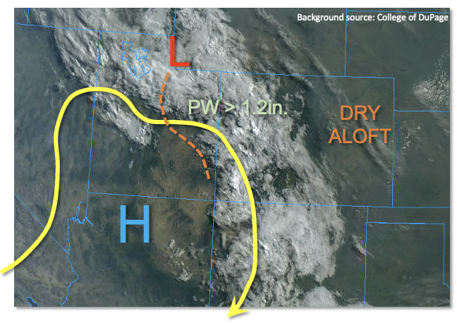
While the past few days’ worth of elevated flood threats has been primarily reliant on copious moisture (and high elevation heating) to drive the heavy rainfall, an important new feature today ups the ante and warrants a HIGH flood threat for the higher terrain. As shown in the visible satellite picture below, this feature is a pronounced disturbance, currently over eastern UT, that is embedded in the upper-level monsoon ridge. This disturbance will trek slowly eastward, bringing in cooling temperatures aloft, promoting a widespread tropical-like rainfall for Colorado’s entire higher terrain.
A strong moisture gradient exists this morning with Denver’s PW of 0.79 inches contrasting with Grand Junction’s 1.30 inches. For the western slope, this high of a PW is within ~10% of their record. Furthermore, Albuquerque’s PW of 1.26 inches and Salt Lake City’s 1.35 inches summarize just how expansive this monsoonal moisture plume is. An expansive cloud deck with showers and weak storms is already ongoing across the western slope, which will limit instability to ~600 J/kg or less. However, just like with Saturday’s rainfall over the Arkansas River basin, instability is essentially a useless metric today since tropical rainfall can occur with almost no instability. The presence of synoptic scale upward motion from the disturbance will be enough to cause a ~12 hour period of persistently moderate to heavy rainfall over the higher terrain, which is what warrants the HIGH threat. In addition to the threat of heavy rainfall, widespread areas have now received more than 1 inch of rain over the past week or so. Thus, there will be a particularly elevated threat of mud flows and debris slides that can respond to rainfall with very long lag times of days.
For the eastern Colorado plains, there will be a sharp gradient in the precipitation shield so that elevations below 8,000 feet are not expected to see much if any rainfall.
Today’s Flood Threat Map
For more information on today’s flood threat, see the map below. If there is a threat, hover over the threat areas for more details, and click on burn areas to learn more about them. For Zone-Specific forecasts, scroll below the threat map.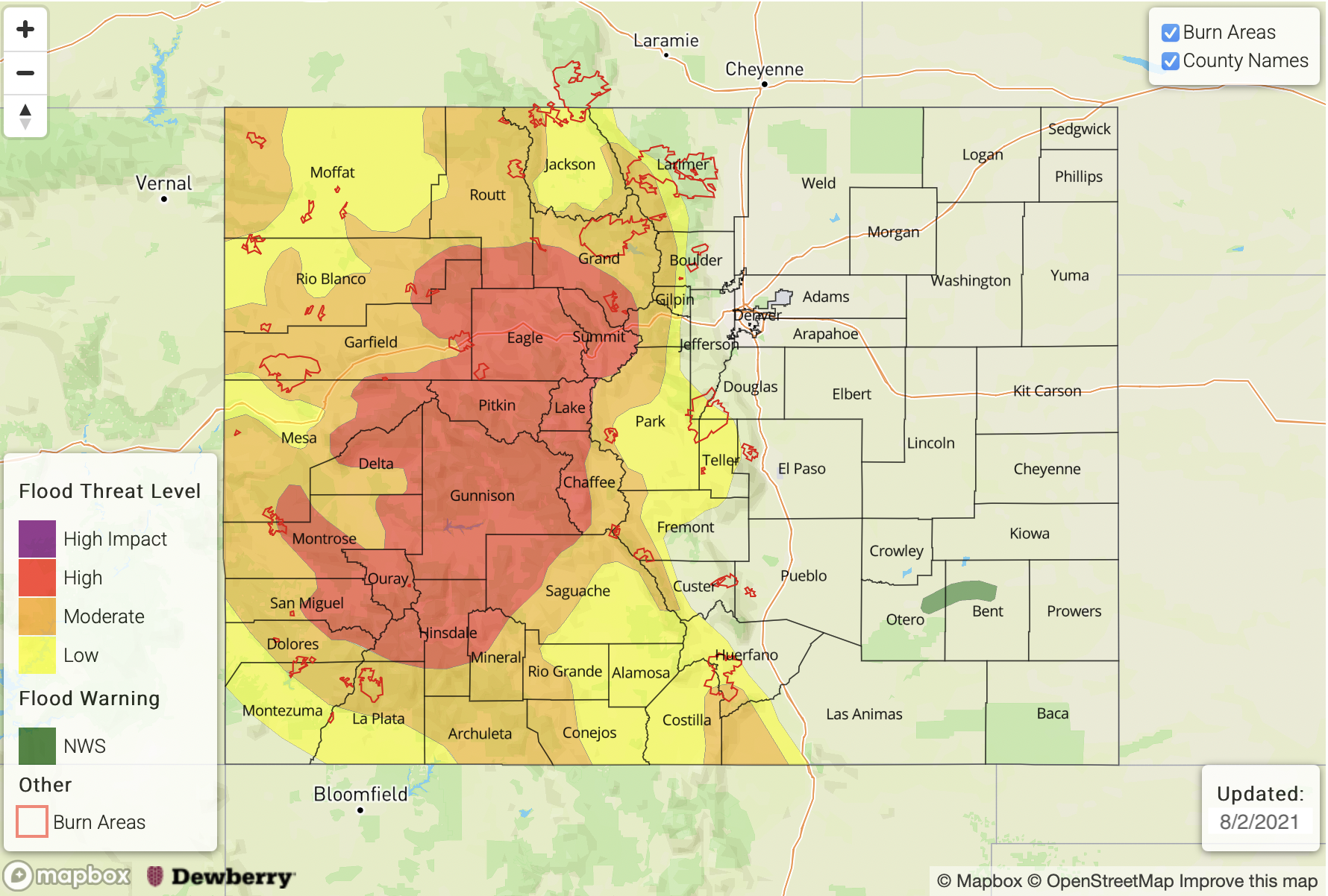
Zone-Specific Forecasts:
Northern Mountains, Central Mountains, Northwest Slope, Grand Valley, Southwest Slope, San Luis Valley, San Juan Mountains, Southeast Mountains and Front Range:
Multiple rounds of showers and thunderstorms from late morning through late evening, especially above 8,000 feet in elevation. Max 30-minute rainfall up to 0.8 inches and max 1-hour rainfall up to 1.5 inches. Over the highest terrain of central Colorado, up to 3.6 inches of rainfall is possible by tomorrow morning, supporting a HIGH flood threat for flash flooding, debris slides and mud flows. Saturated soils will contribute to this threat. Stream and creek flooding will also be possible.
For surrounding locations, a MODERATE/LOW flood threat is posted for more isolated flash flooding, debris slides and mud flows. Up to 2.6 inches of rainfall is possible by morning.
Primetime: 12PM through midnight
Palmer Ridge, Raton Ridge, Southeast Plains, Urban Corridor and Northeast Plains:
Partly cloudy with isolated showers and a few weak thunderstorms possible near the foothills. Dry conditions are expected further east. Max 1-hour rainfall up to 0.6 inches. Flooding is NOT expected today.
Primetime: 2PM through 9PM