Issue Date: Tuesday, August 3rd, 2021
Issue Time: 10:15AM MDT
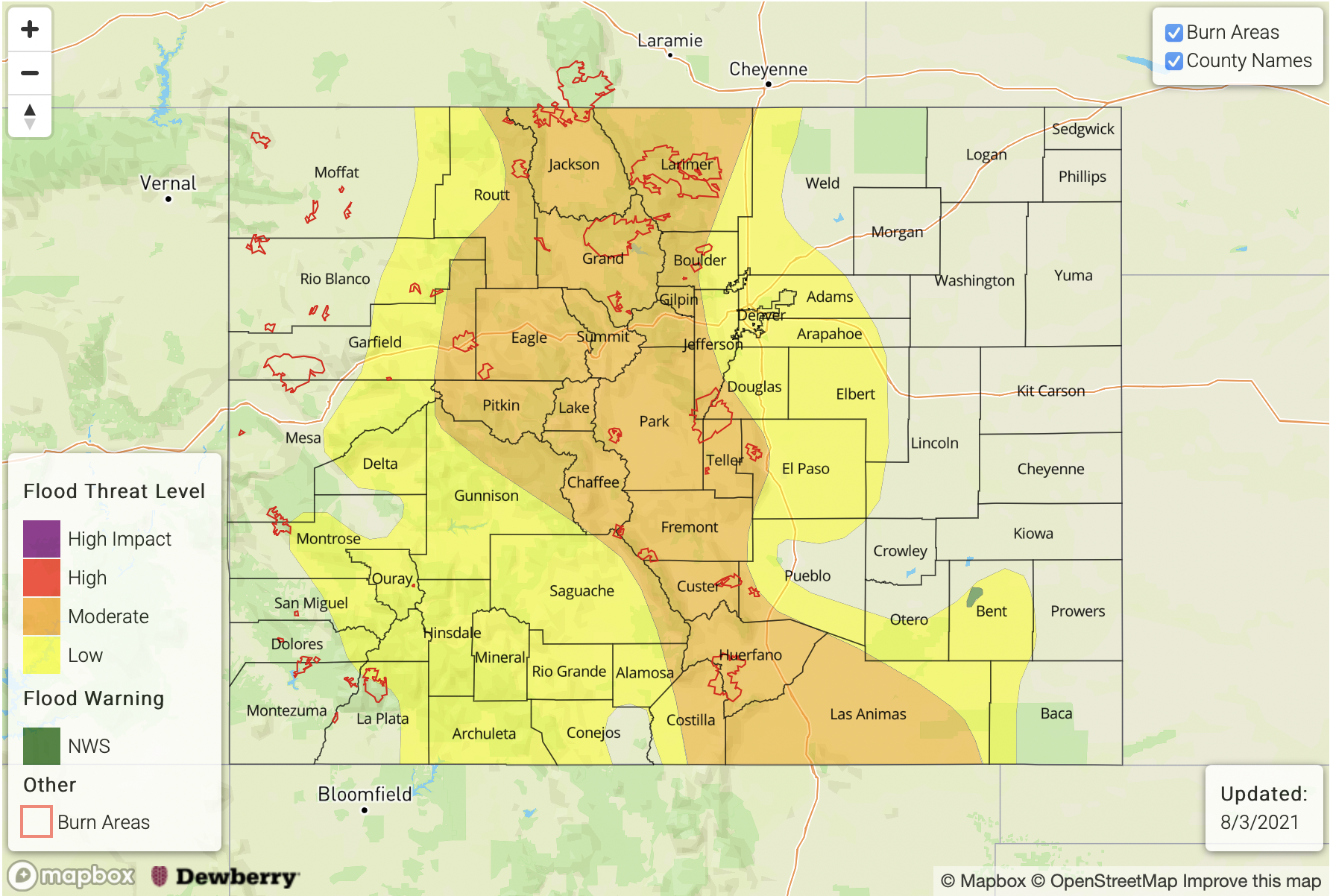
— A MODERATE flood threat has been issued for the Northern Mountains, Central Mountains, Front Range, Southeast Mountains, Raton Ridge and portions of the Southeast Plains
— A LOW flood threat has been issued for the Northwest Slope, Grand Valley, Southwest Slope, San Juan Mountains, San Luis Valley, Urban Corridor and Palmer Ridge
— An NWS Flood Warning is in effect for the Purgatoire River near Las Animas
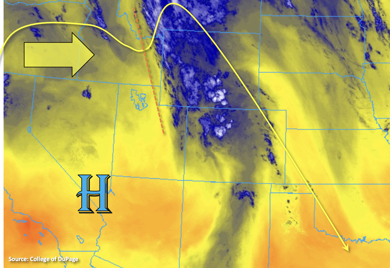
Slow, eastward progression of the trough will continue today (orange dashed line), which will help in returning the heavy rainfall threat to portions of Colorado. This morning, the mid-level lift paired with the PW plume is producing heavy cloud cover and some showers over central Colorado. As the day continues, a drier air mass behind the trough is expected to move across the western border, which will reduce the coverage of rainfall. Particularly for the lower elevations of the western border counties. However, over central Colorado and the immediate eastern adjacent plains, the incoming shortwave and associated plume of moisture (PW > 1 inch) will set the stage for some heavy downpours.
Similar to yesterday, CAPE values will reach only moderate values over the foothills and central mountains due to the ongoing cloud cover. However, with a little daytime heating, storms are expected to pick up in intensity and coverage with the diurnal flow. Slow steering flows and enhance upward motion will cause the threat to be less from the 1-hour rainfall and more in the 2-6 hour time frame. Saturated soils from the last several days of rainfall will also increase the risk for excessive runoff and mud flows/debris slides over the steeper terrains where the stronger storms can develop with better heating. For these reasons, a MODERATE flood threat has been issued.
Storms are expected spill into the adjacent plains by late this afternoon/early this evening, and best coverage of rainfall will likely be over the elevated ridges. Slightly higher instability may be able to build over these areas, especially south, which may allow for a few stronger thunderstorms to develop. Road, local stream/creek and low-lying area flooding will be possible, so a MODERATE flood threat has been issued.

Today’s Flood Threat Map
For more information on today’s flood threat, see the map below. If there is a threat, hover over the threat areas for more details, and click on burn areas to learn more about them. For Zone-Specific forecasts, scroll below the threat map.

Zone-Specific Forecasts:
Grand Valley, San Luis Valley, Northern Mountains, Northwest Slope, Southwest Slope & San Juan Mountains:
Although a drier air mass will be moving in from the west and limit the rainfall chances across the lower elevations, pockets of higher moisture will likely still exist over the elevated terrains. Clearing associated with the drying air mass will also help some decent instability to build where the moisture can hold on. Therefore, a couple isolated thunderstorms are conceivable over the elevated plateaus and mountain regions. Max 1-hour rain rates up to 1.25 along with 2-3 hour totals up to 1.75 inches will be possible. These storms could cause excessive runoff, mud flows and debris slides over already saturated soils, so for these reasons, a MODERATE/LOW flood threat has been issued.
Primetime: 11AM to 10PM
Southeast Mountains, Central Mountains, Front Range, Northeast Plains, Urban Corridor, Raton Ridge, Palmer Ridge & Southeast Plains:
There will be an uptick in storm coverage and rainfall today with the plume and trough moving eastward. Ongoing showers and cloud cover may limit the instability that can build over the Front Range/Central Mountains, but isolated 2-6 hour totals up to 3.25 inches will be possible with the moist adiabatic lapse rates. Similar totals will be possible over the Southeast Mountains. A MODERATE flood threat has been issued for excessive runoff, mud flows and debris slides.
Further south, it is possible for some better instability to build, so as storms roll off the mountains late this afternoon into this evening, a couple stronger thunderstorms may develop. Max 1-hour rain rates up to 1.75 inches will be possible over the Raton Ridge and southern Southeast Mountains. Over the Palmer Ridge and southern Urban Corridor, storm totals up to 1.75 inches will be possible. A MODERATE/LOW flood threat have been issued. Storms may linger into the overnight hours with most activity ending just after midnight.
Primetime: Ongoing to 1AM