Issue Date: Sunday, August 1st, 2021
Issue Time: 10AM MDT
— A MODERATE flood threat has been posted for parts of the Northern Mountains, Central Mountains and San Juan Mountains
— A LOW flood threat has been posted for parts of the San Luis Valley, Northwest Slope, Grand Valley, Southwest Slope and Southeast Mountains
— A NWS Flood Warning is in effect for the Arkansas River just downstream of Pueblo
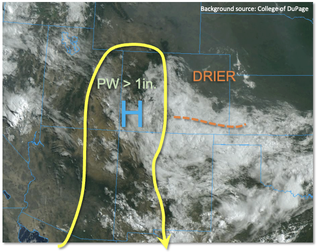
Cool, drier and generally more stable conditions greeted most of eastern Colorado this morning. Denver’s PW has dropped significantly from 1.20 inches to 0.79 inches, with significant drying just above the moist, shallow boundary layer in the wake of the widespread rainfall yesterday. The remnant showers and embedded weak storms from yesterday’s impressive storm complex were still visible south of the Arkansas River. This disturbance will continue to drift south into New Mexico and should have little to no impact on our weather by late afternoon. Pockets of cloud cover will likely persist mainly east of the Continental Divide, and will help to preclude most rainfall activity. The only possible exception is the northern part of the Southeast Mountains that could see some instability re-develop in the still-strong August sun and support isolated heavy rainfall.
Along and west of the Continental Divide, the relentless 2021 monsoon will continue today. Although only moderate instability is expected, to the tune of perhaps 1,000 J/kg locally, very moist conditions will make up for this. Grand Junction morning PW of 1.19 inches is significantly above normal, with a nearly moist-adiabat sounding suggestive of efficient warm-coalescence rainfall generation today (similar to what occurred over southeast Colorado yesterday). Storm motions will be somewhat erratic and fairly slow, perhaps 10-15 mph, which could support training of storms as they interact with the circulations caused by the normal topographic heating. A MODERATE/LOW flood threat is warranted again for basically the entire western slope today as 30-60 minute periods of very heavy rainfall are likely yet again. The highest coverage will be over the higher terrain above 8,000 feet, but enough moisture exists for storms to reach the valley floors once again. Saturated soils from the recent rains will also help expedite runoff.
Today’s Flood Threat Map
For more information on today’s flood threat, see the map below. If there is a threat, hover over the threat areas for more details, and click on burn areas to learn more about them. For Zone-Specific forecasts, scroll below the threat map.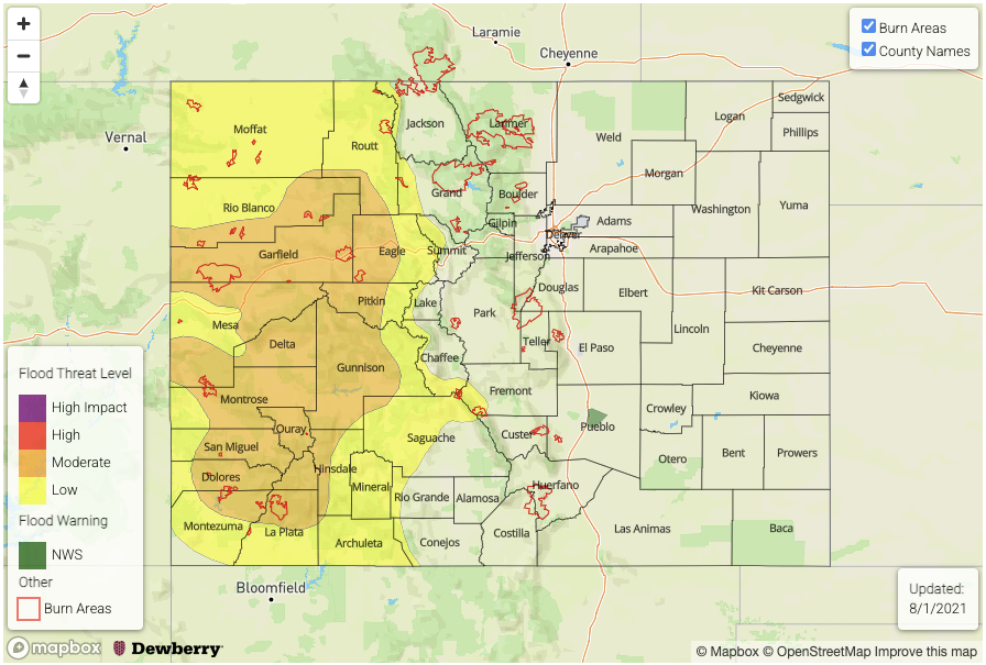
Zone-Specific Forecasts:
Southeast Mountains, Northern Mountains, Central Mountains, Northwest Slope, Grand Valley, Southwest Slope, San Luis Valley and San Juan Mountains:
Numerous to widespread showers and thunderstorms this afternoon and evening, especially above 8,000 feet in elevation. Max 30-minute rainfall up to 0.9 inches and max 1-hour rainfall up to 1.7 inches support a MODERATE/LOW flood threat for isolated flash flooding, debris slides and mud flows. Many debris slides and mud flows have been reported in previous days, and it is likely that saturated soils are contributing to the ease of generating new events.
Primetime: 12PM through 10PM
Front Range, Palmer Ridge, Raton Ridge, Southeast Plains, Urban Corridor and Northeast Plains:
Early rain showers and weak thunderstorms south of the Arkansas River, then becoming partly cloudy and continued cool with an isolated shower or storm possible along the higher terrain and foothills east of the Continental Divide. Max 1-hour rainfall up to 0.5 inches possible, but flooding is NOT expected today.
Primetime: 2PM through 9PM