FTB 06-07-2018: Moisture Returns to the Eastern Plains for an Afternoon of Severe Thunderstorms and Local, Heavy Rainfall

Issue Date: Thursday, June 7, 2018
Issue Time: 10:15AM MDT

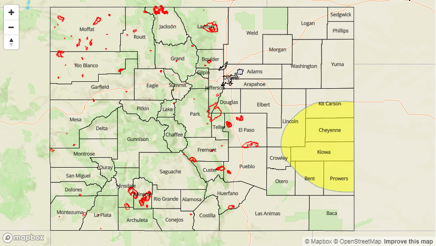
— A LOW flood threat has been issued for portions of the Northeast Plains, Palmer Ridge and Southeast Plains

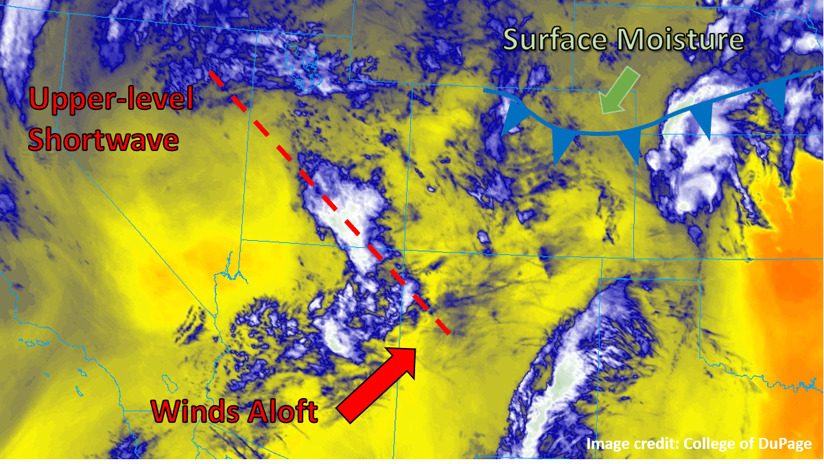
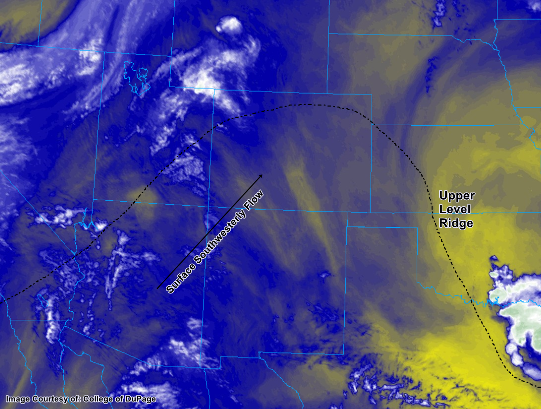
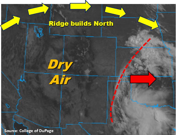
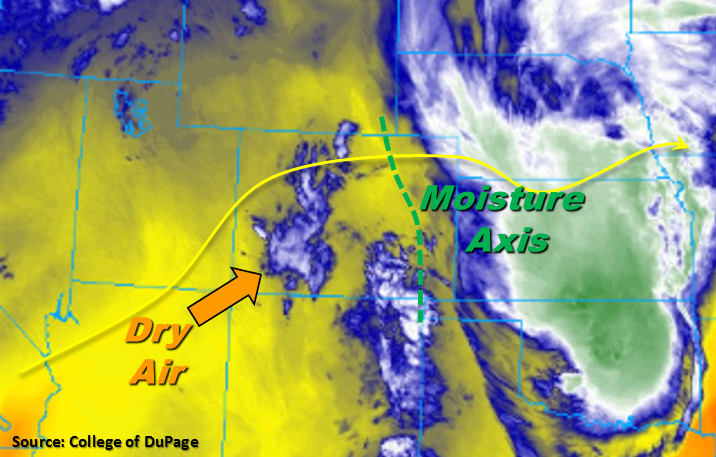
Colorado continues to reside under the persistent ridge pattern once again today. This means that for most of the state, dry air will continue to be entrained from the southwest and will limit rainfall chances to the east of the Continental Divide. The 416 fire in Durango continues to burn out of control with no chance of rainfall again this afternoon. Currently a ripple in the 500mb flow is moving over the San Juan and Central Mountains, which is producing cloud cover over the higher terrains. This will move east throughout the morning and dry air will move in behind it yielding nearly clear skies for this afternoon and above average temperatures. The disturbance that brought heavy rainfall to Yuma County last night is currently over KS and will continue to move east throughout the morning.

Moisture is expected to return to the eastern plains again today with S/SE low-level flow. The moisture axis for this afternoon is marked in green below. West of this line, thunderstorms and showers are expected to be more isolated in coverage with the best chance for measurable precipitation over the Palmer Ridge and southern Front Range. However, dew points in the in the low 30Fs will cause more gusty winds than measureable rainfall. As storms move east of this line, high CAPE values, increased moisture and decent shear will combine to produce another afternoon and evening of severe thunderstorms. Thunderstorms will be more isolated in nature today, but expecting storms to produce strong outflow boundaries that may trigger additional storms in the area. With storm motion to the E/SE at 10-15 knots, local heavy rainfall is possible near the CO/KS border this evening similar to last night. Threats include large hail (up to 2 inches in diameter), winds gust of 60 mph, street flooding and field ponding. A Low flood threat has been issued for portions of the Northeast Plains, Palmer Ridge and Southeast Plains. For more information on rain rates and timing, please see the zone-specific forecast discussions below.

Today’s Flood Threat Map

For more information on today’s flood threat, see the map below. For Zone-Specific forecasts, scroll below the map.

Flood Threat Legend

Zone-Specific Forecasts:

Palmer Ridge, Front Range, Urban Corridor, Northeast Plains, Southeast Plains, Raton Ridge, Southeast Mountains:

Isolated showers and thunderstorms will be possible over the higher terrains this afternoon. The best coverage will be over the Southern Front Range and Palmer Ridge intersect. Rain rates up to 0.7 inches/hour are possible with the stronger storms. All storms west of the moisture line will produce gusty winds. East, max 1-hour rain rates up to 2 inches are possible near the CO/KS border. Threats include heavy local rainfall, large hail and strong gusts. Storms should move into KS by 1AM. A Low flood threat has been issued.

Primetime: 3PM – 1AM

San Luis Valley, San Juan Mountains, Northern Mountains, Southwest Slope, Grand Valley, Central Mountains, Northwest Slope:

Southwest flow continues to pull in dry air under the ridge, which squashes any chance for rainfall this afternoon. Temperatures continue to be well above normal with high temperatures reaching the mid-90Fs for the lower elevations. Winds are expected to only reach 10-15 mph this afternoon, which should aid in preventing rapid growth of the 416 fire. There is no flood threat today.


FTB 06-06-2018: Weak Cold Front Will Bring Chance of Storms for Some

Issue Date: Wednesday, June 6, 2018
Issue Time: 09:45AM MDT

— Flooding is NOT expected today.

Much of the state was subjected to its hottest day of the year so far yesterday, with temperatures in the low country soaring well into the 90°Fs. While most locations are expected to remain above seasonal average temperatures today, a weak cold front is edging its way into the northeastern corner of the state as of this morning (see graphic below), bringing slightly cooler and significantly moister air. In addition to surface conditions becoming more favorable for thunderstorms today, some upper-level support for convection in the form of a weak, subtle shortwave (dashed red line in figure) is anticipated today. While not particularly robust, the shortwave is expected to cross the mountains and into the eastern plains just after midday and into the early afternoon today, providing extra lift at an ideal time for generating afternoon and evening storms.

The cold front is expected to continue sagging south throughout the day, but will likely not make it further south than the Palmer Ridge before washing out. The bulk of the thunderstorm activity is expected along and north of this boundary, where the passing shortwave will have the most surface moisture to work with and winds will be an upslope northeasterly. Storms may even produce some severe weather along and northeast of a line from the CO/WY/NE border region down to the southeast corner of the state (including towns like Springfield and Lamar). All threats are possible, with hail and wind being the most likely forms of severe weather. Storms that do form are expected to grow upscale into a large cluster before exiting the state into Kansas and Nebraska later this evening. Rainfall may be briefly heavy, but winds aloft should keep the storms moving off to the east or northeast at a decent clip, limiting the threat of sustained heavy rain. No flooding is expected today.

Today’s Flood Threat Map

For more information on today’s flood threat, see the map below. For Zone-Specific forecasts, scroll below the map.

Zone-Specific Forecasts:

Front Range, Urban Corridor, Northeast Plains, Palmer Ridge, Southeast Plains:

Partly cloudy and warm to begin the day, with clouds increasing as the shortwave approaches this afternoon. Storms will begin to fire over the Front Range and the eastern plains by early afternoon, with some severe weather possible over eastern portions of the area. The heaviest rain will be from the Palmer Ridge to the northeast, with rain rates of around 1 inch/hour possible under the strongest storms. With the scattered nature of the rainfall, totals will vary widely, but total accumulations of up to 2” are not out of the question in isolated locations.

Primetime: 1PM to Midnight

Northwest Slope, Northern Mountains, Central Mountains, Grand Valley, Southwest Slope, San Juan Mountains, San Luis Valley, Southeast Mountains, Raton Ridge:

Partly cloudy with continuing warm conditions for most today, with just a small chance of a brief, isolated shower or thunderstorm near some of the high mountain peaks today.

FTB 06-05-2018: Heat in Full Force Today Leading in to Afternoon Thunderstorms

Issue Date: Tuesday, June 5, 2018
Issue Time: 10:25 AM MDT

— Flooding is NOT expected today

South to southwesterly winds near the surface today will make for another unseasonably hot afternoon for much of Colorado. This is due to a large upper air ridge that is sitting almost directly above Colorado this morning – the crest of this ridge situated almost exactly in the middle of the state. West of the continental divide, despite seeing some weekend rainfall, will be too dry to see any weather other than increasing clouds throughout the day. While dry weather has persisted east of the divide as well, this part of the state will see a boost in its chance for thunderstorms due to small disturbance at the crest of the ridge. This kink may help generate enough atmospheric lift to trigger thunderstorm development this afternoon and evening.

With the combination of the hot surface air rising and a modest increase in relative humidity values in the middle layers of the atmosphere, there is an appreciable chance for thunderstorms from the Front Range and Urban Corridor east to the plains. Mid-level moisture will not be enough to churn out significant thunderstorms, however, and rainfall rates will generally be confined to about 0.1 to 0.25 inches per hour. No flood threat is forecast today.

Today’s Flood Threat Map

For more information on today’s flood threat, see the map below. For Zone-Specific forecasts, scroll below the map.

Zone-Specific Forecasts:

Palmer Ridge, Northeast Plains, Southeast Plains, and Raton Ridge:

Temperatures well into the 90s are forecast for today, with initially sunny conditions leading to increasing cloud cover as the day progresses. By around 5pm, towering thunderstorms are anticipated to begin forming over the area, especially over the Palmer Ridge. Rainfall will likely start as virga, but as the lower atmosphere continues to moisten as thunderstorms pass overhead the rain will likely be able to make it all the way to the surface. Rainfall rates are forecast to generally be between 0.1 to 0.25 inches per hour, but underneath the strongest thunderstorms brief periods of up to 0.5 inches per hour are possible. No flood threat is forecast today.

Primetime: 5 PM to 12 AM

Northern Mountains, Central Mountains, Front Range, and Urban Corridor:

For today, expect unseasonably hot conditions accompanied by a south/southwest wind. As the afternoon progresses, cumulus clouds will build with some managing to develop into thunderstorms. Given how dry the atmosphere is near the surface, rain showers will likely only be noticeable as wispy virga from the ground. Should the showers be persistent, however, a few areas may see measurable rainfall late in the afternoon and into the evening. Hourly rainfall rates are not expected to exceed 0.25 inches, and no flood threat is forecast.

Primetime: 3 PM to 10 PM

Northwest Slope, Southwest Slope, Grand Valley, San Juan Mountains, San Luis Valley, and Southeast Mountains:

Plenty of sunshine today with fair weather cumulus clouds forming in the afternoon. Southerly winds will bring in hot and dry air throughout the region, and while no substantial fire danger exists today, use caution with open flames or flammable substances outdoors. No appreciable rainfall is expected.

FTB 06-04-2018: Drying Pattern Set in Motion as Ridge Begins to Build

Issue Date: Monday, June 4, 2018
Issue Time: 08:40AM MDT

— Flooding is NOT expected today

The disturbance that brought rainfall to the southern portion of the state yesterday is marked in the visible image below (red). This will continue to move to the east throughout the day, and in its wake, a ridge of high pressure will begin to build north of Colorado. This will create more westerly flow aloft, which will pull in dry air from the southwest. Thus, the drying pattern for the week has begun. Today showers will be more isolated in nature and high temperatures are expected to climb back into the 90s over the lower elevations.

East of the Continental Divide, storms will initiate over the higher terrains of the Cheyenne Ridge and Palmer Ridge later this afternoon. Some low-level moisture is able to hold on over the Northeast Plains with more south/southeasterly flow. With storm motion to the southeast, the storms coming off the Cheyenne Ridge may be able to drop a quick 0.5 inches of rainfall over the far Northeast Plains. However, an inversion at 700mb may put a kibosh on all convection. Over the Southeast Plains, dew point values will be in the upper 30s, so expect storms that form over the Palmer Ridge to produce gusty winds and total rainfall amounts under 0.2 inches. Lastly, west of the Continental Divide, there is a little residual moisture over the San Juan Mountains. This will help spark some very isolated scattered showers and thunderstorms later this afternoon over the higher terrain. Rainfall amounts under the storm cores are expected to be under 0.1 inches and strong gusts are likely. Flooding is not expected today.

Today’s Flood Threat Map

For more information on today’s flood threat, see the map below. For Zone-Specific forecasts, scroll below the map.

Zone-Specific Forecasts:

Palmer Ridge, Front Range, Urban Corridor, Northern Mountains, Northeast Plains, Southeast Plains, Raton Ridge, Southeast Mountains:

A couple scattered showers and thunderstorms will be possible over the Northeast Plains and Southeast Plains. If they are able to break the cap, better moisture to the north will allow max 1-hour rain rates up to 0.5 inches. Further south, dew points in the mid to upper 30s will keep rainfall totals under 0.2 inches. Expected gusty winds under all storms that form today. Storms should quickly dissipate with increased stability after sundown. Flooding is not expected today.

Primetime: 3PM – 9PM

San Luis Valley, San Juan Mountains, Southwest Slope, Grand Valley, Central Mountains, Northwest Slope:

Residual moisture over the San Juan Mountains will allow some isolated showers and thunderstorms to fire over the higher terrains this afternoon. Storm totals are expected to be under 0.1 inches and gusts up to 45mph are possible. Elsewhere, expect clear skies and high temperatures in the lower elevations to reach 90F. There is no flood threat today.

Primetime: 3PM – 8:30PM