Issue Date: Tuesday, June 5, 2018
Issue Time: 10:25 AM MDT
— Flooding is NOT expected today
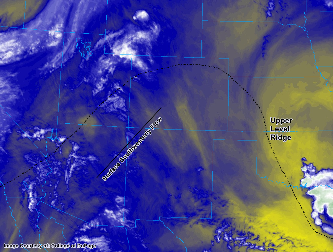
South to southwesterly winds near the surface today will make for another unseasonably hot afternoon for much of Colorado. This is due to a large upper air ridge that is sitting almost directly above Colorado this morning – the crest of this ridge situated almost exactly in the middle of the state. West of the continental divide, despite seeing some weekend rainfall, will be too dry to see any weather other than increasing clouds throughout the day. While dry weather has persisted east of the divide as well, this part of the state will see a boost in its chance for thunderstorms due to small disturbance at the crest of the ridge. This kink may help generate enough atmospheric lift to trigger thunderstorm development this afternoon and evening.
With the combination of the hot surface air rising and a modest increase in relative humidity values in the middle layers of the atmosphere, there is an appreciable chance for thunderstorms from the Front Range and Urban Corridor east to the plains. Mid-level moisture will not be enough to churn out significant thunderstorms, however, and rainfall rates will generally be confined to about 0.1 to 0.25 inches per hour. No flood threat is forecast today.
Today’s Flood Threat Map
For more information on today’s flood threat, see the map below. For Zone-Specific forecasts, scroll below the map.

Zone-Specific Forecasts:
Palmer Ridge, Northeast Plains, Southeast Plains, and Raton Ridge:
Temperatures well into the 90s are forecast for today, with initially sunny conditions leading to increasing cloud cover as the day progresses. By around 5pm, towering thunderstorms are anticipated to begin forming over the area, especially over the Palmer Ridge. Rainfall will likely start as virga, but as the lower atmosphere continues to moisten as thunderstorms pass overhead the rain will likely be able to make it all the way to the surface. Rainfall rates are forecast to generally be between 0.1 to 0.25 inches per hour, but underneath the strongest thunderstorms brief periods of up to 0.5 inches per hour are possible. No flood threat is forecast today.
Primetime: 5 PM to 12 AM
Northern Mountains, Central Mountains, Front Range, and Urban Corridor:
For today, expect unseasonably hot conditions accompanied by a south/southwest wind. As the afternoon progresses, cumulus clouds will build with some managing to develop into thunderstorms. Given how dry the atmosphere is near the surface, rain showers will likely only be noticeable as wispy virga from the ground. Should the showers be persistent, however, a few areas may see measurable rainfall late in the afternoon and into the evening. Hourly rainfall rates are not expected to exceed 0.25 inches, and no flood threat is forecast.
Primetime: 3 PM to 10 PM
Northwest Slope, Southwest Slope, Grand Valley, San Juan Mountains, San Luis Valley, and Southeast Mountains:
Plenty of sunshine today with fair weather cumulus clouds forming in the afternoon. Southerly winds will bring in hot and dry air throughout the region, and while no substantial fire danger exists today, use caution with open flames or flammable substances outdoors. No appreciable rainfall is expected.