Issue Date: Wednesday, June 6, 2018
Issue Time: 09:45AM MDT
— Flooding is NOT expected today.
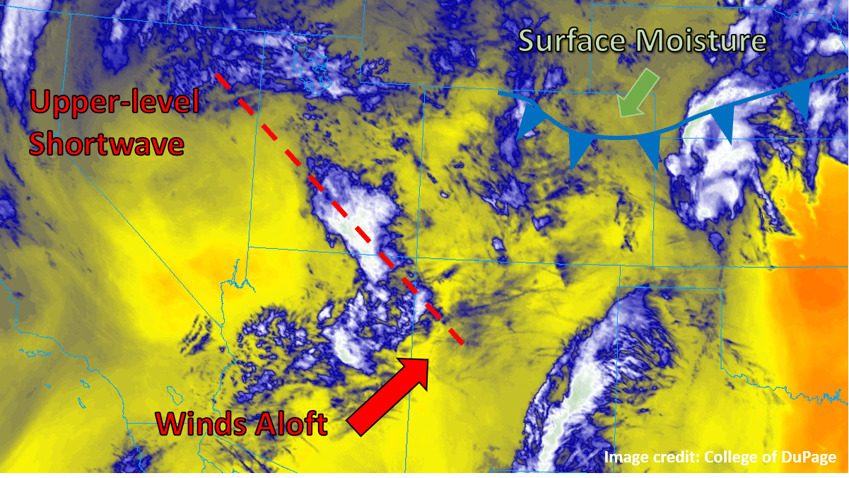
Much of the state was subjected to its hottest day of the year so far yesterday, with temperatures in the low country soaring well into the 90°Fs. While most locations are expected to remain above seasonal average temperatures today, a weak cold front is edging its way into the northeastern corner of the state as of this morning (see graphic below), bringing slightly cooler and significantly moister air. In addition to surface conditions becoming more favorable for thunderstorms today, some upper-level support for convection in the form of a weak, subtle shortwave (dashed red line in figure) is anticipated today. While not particularly robust, the shortwave is expected to cross the mountains and into the eastern plains just after midday and into the early afternoon today, providing extra lift at an ideal time for generating afternoon and evening storms.
The cold front is expected to continue sagging south throughout the day, but will likely not make it further south than the Palmer Ridge before washing out. The bulk of the thunderstorm activity is expected along and north of this boundary, where the passing shortwave will have the most surface moisture to work with and winds will be an upslope northeasterly. Storms may even produce some severe weather along and northeast of a line from the CO/WY/NE border region down to the southeast corner of the state (including towns like Springfield and Lamar). All threats are possible, with hail and wind being the most likely forms of severe weather. Storms that do form are expected to grow upscale into a large cluster before exiting the state into Kansas and Nebraska later this evening. Rainfall may be briefly heavy, but winds aloft should keep the storms moving off to the east or northeast at a decent clip, limiting the threat of sustained heavy rain. No flooding is expected today.
Today’s Flood Threat Map
For more information on today’s flood threat, see the map below. For Zone-Specific forecasts, scroll below the map.

Zone-Specific Forecasts:
Front Range, Urban Corridor, Northeast Plains, Palmer Ridge, Southeast Plains:
Partly cloudy and warm to begin the day, with clouds increasing as the shortwave approaches this afternoon. Storms will begin to fire over the Front Range and the eastern plains by early afternoon, with some severe weather possible over eastern portions of the area. The heaviest rain will be from the Palmer Ridge to the northeast, with rain rates of around 1 inch/hour possible under the strongest storms. With the scattered nature of the rainfall, totals will vary widely, but total accumulations of up to 2” are not out of the question in isolated locations.
Primetime: 1PM to Midnight
Northwest Slope, Northern Mountains, Central Mountains, Grand Valley, Southwest Slope, San Juan Mountains, San Luis Valley, Southeast Mountains, Raton Ridge:
Partly cloudy with continuing warm conditions for most today, with just a small chance of a brief, isolated shower or thunderstorm near some of the high mountain peaks today.