Issue Date: Monday, June 4, 2018
Issue Time: 08:40AM MDT
— Flooding is NOT expected today
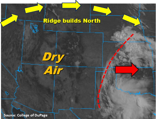
The disturbance that brought rainfall to the southern portion of the state yesterday is marked in the visible image below (red). This will continue to move to the east throughout the day, and in its wake, a ridge of high pressure will begin to build north of Colorado. This will create more westerly flow aloft, which will pull in dry air from the southwest. Thus, the drying pattern for the week has begun. Today showers will be more isolated in nature and high temperatures are expected to climb back into the 90s over the lower elevations.
East of the Continental Divide, storms will initiate over the higher terrains of the Cheyenne Ridge and Palmer Ridge later this afternoon. Some low-level moisture is able to hold on over the Northeast Plains with more south/southeasterly flow. With storm motion to the southeast, the storms coming off the Cheyenne Ridge may be able to drop a quick 0.5 inches of rainfall over the far Northeast Plains. However, an inversion at 700mb may put a kibosh on all convection. Over the Southeast Plains, dew point values will be in the upper 30s, so expect storms that form over the Palmer Ridge to produce gusty winds and total rainfall amounts under 0.2 inches. Lastly, west of the Continental Divide, there is a little residual moisture over the San Juan Mountains. This will help spark some very isolated scattered showers and thunderstorms later this afternoon over the higher terrain. Rainfall amounts under the storm cores are expected to be under 0.1 inches and strong gusts are likely. Flooding is not expected today.
Today’s Flood Threat Map
For more information on today’s flood threat, see the map below. For Zone-Specific forecasts, scroll below the map.

Zone-Specific Forecasts:
Palmer Ridge, Front Range, Urban Corridor, Northern Mountains, Northeast Plains, Southeast Plains, Raton Ridge, Southeast Mountains:
A couple scattered showers and thunderstorms will be possible over the Northeast Plains and Southeast Plains. If they are able to break the cap, better moisture to the north will allow max 1-hour rain rates up to 0.5 inches. Further south, dew points in the mid to upper 30s will keep rainfall totals under 0.2 inches. Expected gusty winds under all storms that form today. Storms should quickly dissipate with increased stability after sundown. Flooding is not expected today.
Primetime: 3PM – 9PM
San Luis Valley, San Juan Mountains, Southwest Slope, Grand Valley, Central Mountains, Northwest Slope:
Residual moisture over the San Juan Mountains will allow some isolated showers and thunderstorms to fire over the higher terrains this afternoon. Storm totals are expected to be under 0.1 inches and gusts up to 45mph are possible. Elsewhere, expect clear skies and high temperatures in the lower elevations to reach 90F. There is no flood threat today.
Primetime: 3PM – 8:30PM