FTB 08-01-2022: Widely Scattered Storms Forecast With Monsoon Moisture Remaining over Southern and Western Colorado

Issue Date: Monday, August 1st, 2022
Issue Time: 10:55 AM MDT

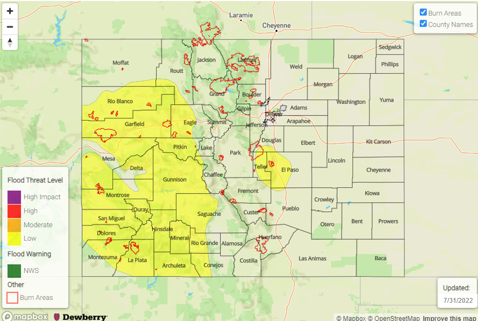
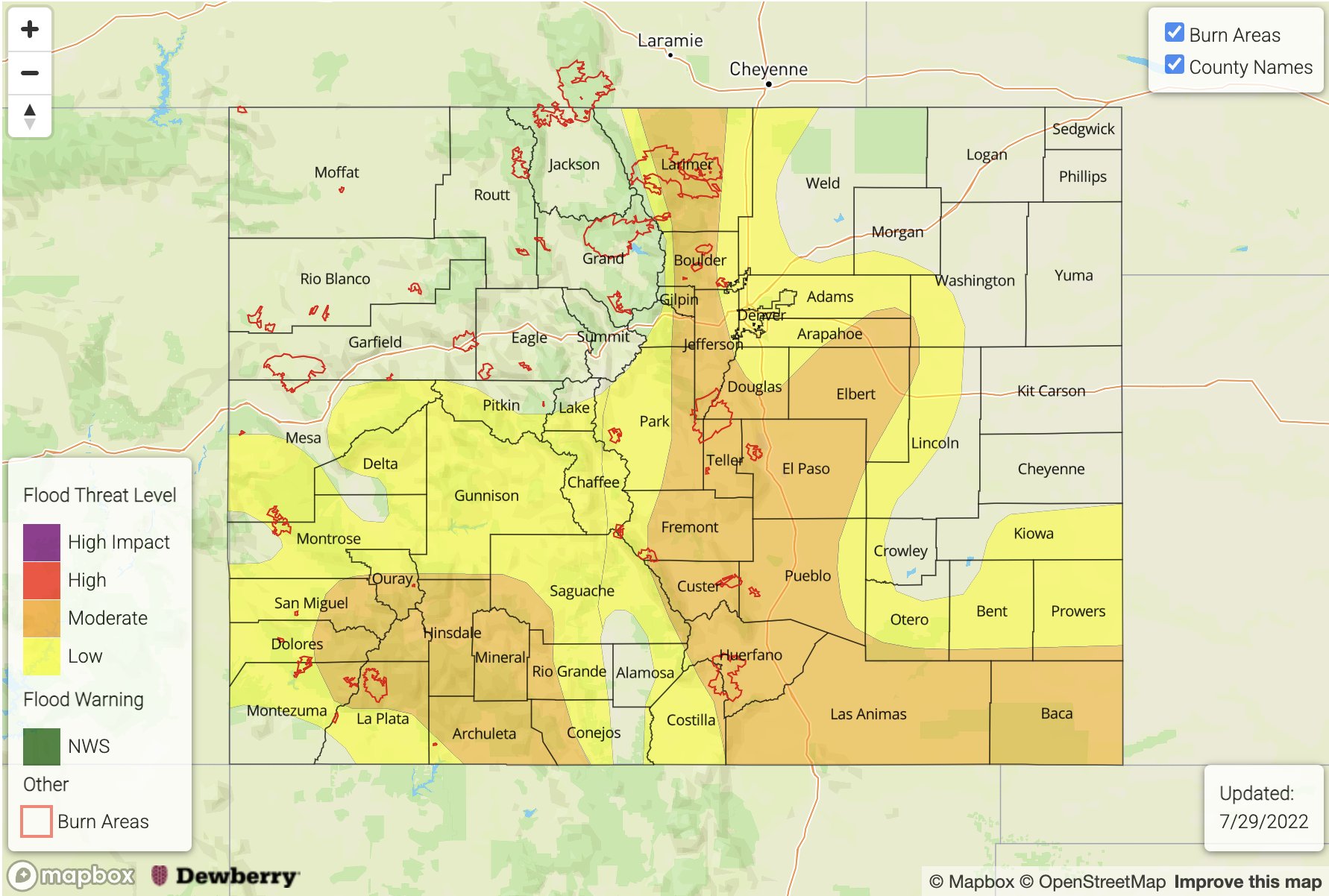
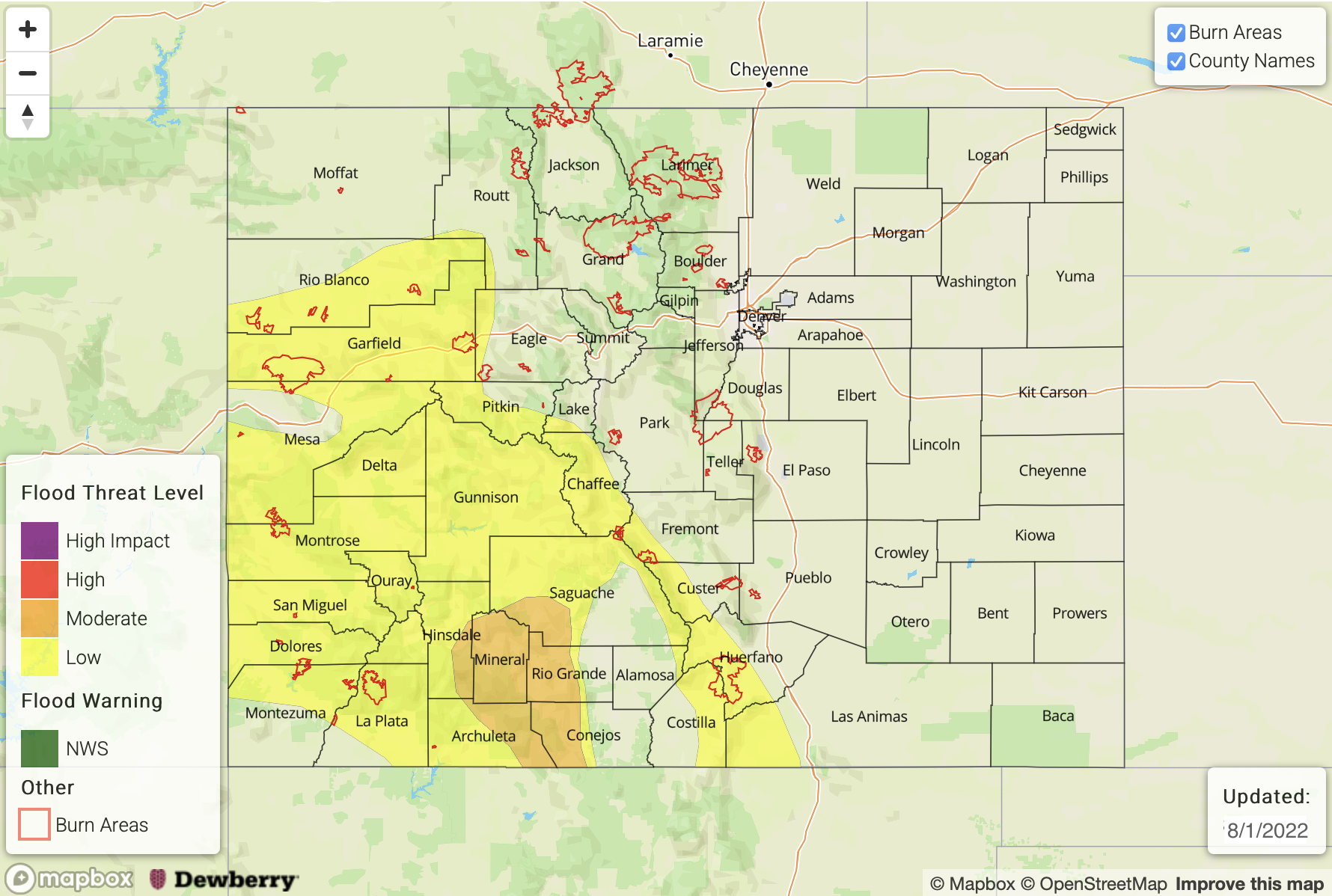
— A MODERATE flood threat has been issued for portions of the San Juan Mountains
— A LOW flood threat has been issued for the Southeast Mountains, Southwest Slope, Grand Valley and portions of the Central Mountains and Northwest Slope
Fire-Burn Forecast Summary: 4 burn areas under MODERATE threat, 2 burn areas under LOW threat, click HERE for more info 

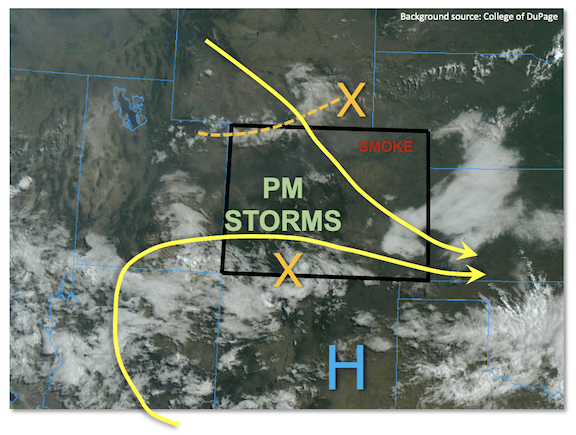
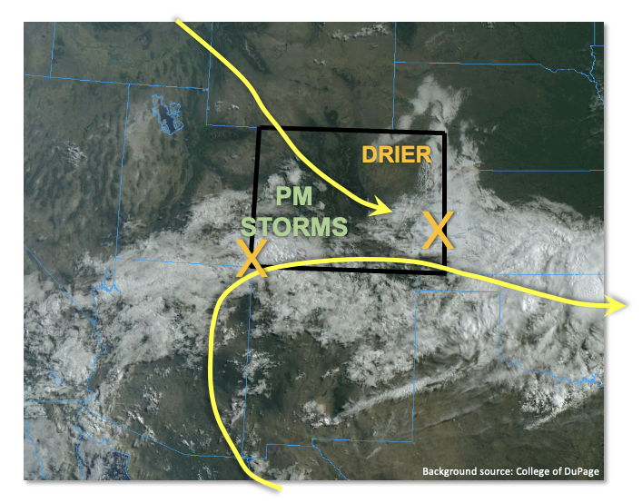
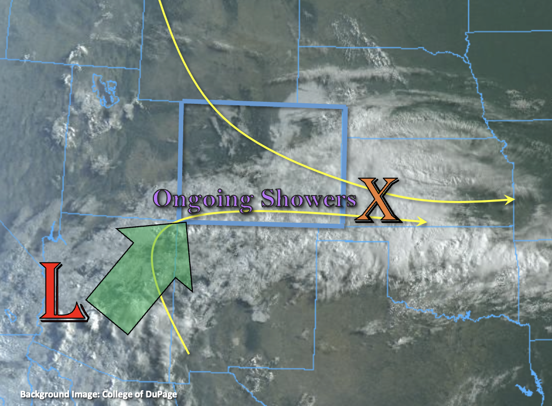
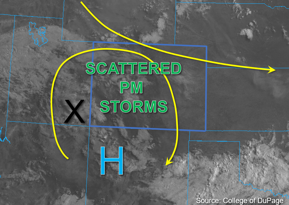
There are some high clouds over the mountains and southwest corner of the state to start the day, but August is off to a pleasant start for most this morning with afternoon temperatures on the rise statewide. The upper air pattern looks similar to yesterday with clockwise rotation around the High, which should progress slightly northeastward throughout the day and help to keep convection more isolated to widely scattered over the high terrains. Additionally, a mid-level disturbance in the flow is located over southeastern Utah this morning, as shown by the “X” in the water vapor image below. This should help provide a focal point for storm development over southwestern Colorado by midday.

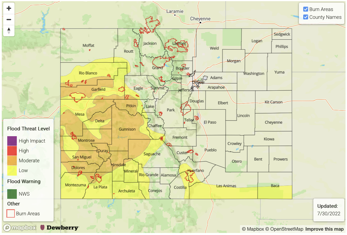
Plenty of residual monsoonal moisture remains over the western half of the state and southern Colorado this morning with PW observed at 1.10 inches in Grand Junction and 1 inch values estimated across southwest Colorado. There is also less cloud cover than the last couple of days over the area, which should allow for plenty of warming by this afternoon. As the disturbance moves eastward, topographic influence along with instability in the range of 700-1000 J/kg of CAPE should provide plenty of uplift for at widely scattered storm development over the higher terrains. Given the forecasted weak steering flow, these small storms should again have the potential to drop heavy rainfall in a 30-minute period. Storms should become more scattered over the eastern and southern San Juan Mountains this evening with moderate to light on and off rainfall forecast. These could produce an additional 1 inch+ of rainfall by morning. After several consecutive days of rainfall over this region (see the SPM), both the convective storms and more widespread rainfall will increase the flood threat if they track over the saturated soils. For this reason, a MODERATE flood threat has been issued with a LOW flood threat extending northwards and eastwards over the high terrains.

East of the Continental Divide, boundary layer moisture is more limited and is expected to mix out by early this afternoon. Still, with PW at Platteville around 0.70 inches, a few weak storms are possible over the mountains. An isolated storm or two may drift off the Cheyenne Ridge into the Northeastern Plains Colorado this afternoon, but storms should mostly stick to the mountains with SSE steering flow. Slightly higher moisture was noted over the Southeast Mountains and with extra mid-level lift moving through the area, an isolated storm may produce some flooding issues over the Southeast Mountains. A LOW flood threat has been issued.

Today’s Flood Threat Map

For more information on today’s flood threat, see the map below. If there is a threat, hover over the threat areas for more details, and click on burn areas to learn more about them. For Zone-Specific forecasts, scroll below the threat map.

Zone-Specific Forecasts:


Southwest Slope, San Juan Mountains, San Luis Valley, Grand Valley, Central Mountains, Northwest Slope & Northern Mountains:

Local heavy downpours will be possible with the small storm cores that develop this afternoon and evening. Max 30-minute rain rates up to 1.25 inches and 1-hour rain rates up to 1.5 inches will be possible, which could cause isolated mud flows, debris slides and excessive runoff. This is especially true if they track over already saturated soils. More widespread totals in the 1 to 1.5 inch range over the San Juan Mountains will have the potential to cause rises in local streams and rivers with increased runoff from saturated soils, so a MODERATE flood threat has been issued. Further north, max 30-minute rain rates up to 1.1 inches will be possible, which could cause isolated road flooding and debris and mud flows. A LOW floor threat has been issued. Lighter showers may linger over the high terrains tonight through tomorrow morning (most likely north).

Primetime: 12PM to Ongoing

Front Range, Urban Corridor, Northeast Plains, Palmer Ridge, Southeast Plains, Raton Ridge, & Southeast Mountains:

Heavy rainfall chances remain across the southern high terrains with max 30-hour rain rates up to 1.25 inches possible. This could cause isolated mud flows and debris slides as well as road flooding over steeper terrains. A LOW flood threat has been issued. Further north, isolated max 30-minute rain rates up to 0.5 inches will be possible, which will limit the flood threat.

Primetime: 1PM to 11PM

FTB 07-31-2022: Isolated Heavy Rainfall Expected, Mainly West

Issue Date: Sunday, July 31st, 2022
Issue Time: 10:15AM MDT
— A LOW flood threat has been posted for parts of the Central Mountains, San Juan Mountains, Southwest Slope and Palmer Ridge
Fire-Burn Forecast Summary: 4 burn areas under MODERATE flood threat; 5 burn areas under LOW threat; click HERE for more info

The last day of July will close on a very similar note as the rest of the month: plenty of moisture remains somewhere across Colorado to force a heavy rainfall threat! Looking at the visible satellite image, below, a split flow pattern continues across the Four Corners. A residual disturbance from last night’s storm activity remains along the NM border, and will act as a bit of a focal point for additional storms today. The monsoonal ridge will intensify today, and build northwestward towards Utah. This will promote warmer temperatures east of the Continental Divide, along with lower rainfall chances. To the west, plenty of moisture remains stuck “under” the ridge. PW this morning at Grand Junction came in 1.10 inches, well above normal for this time of year. Furthermore, the lower levels of the atmosphere were quite moist and prime for heavy rainfall generation. PW in the 0.9 – 1.2 range will be expected for western Colorado. With plenty of sunshine expected, instability up to 900 J/kg CAPE and very slow storm motion will suffice for supporting scattered showers and storms during the afternoon and evening hours along and west of the Continental Divide. However, with the building ridge, expect slightly reduced coverage overall compared to yesterday along with a preference for staying over the higher terrain. Thus, yesterday’s Moderate threat will be bumped down to a LOW to account for 30-60 minutes of heavy rainfall potential and associated threat of excessive runoff.

To the east of the Continental Divide, some recovery in moisture has occurred with PW at the Platteville research station at around 0.77 inches (just below seasonal normal). A disturbance along the WY border will skirt ESE into Colorado this afternoon, setting the focal point for widely scattered showers and storms. With quicker steering flow expected later this afternoon, these storms will pose more of a gusty wind threat although brief moderate/heavy rainfall will occur. Further south, however, with more moisture noted this morning along the Palmer Ridge in the Pikes Peak region, a LOW flood threat is warranted for this climatologically favored area as storms could anchor to the terrain just long enough to cause a 60 minute heavy rainfall threat.

Today’s Flood Threat Map

For more information on today’s flood threat, see the map below. If there is a threat, hover over the threat areas for more details, and click on burn areas to learn more about them. For Zone-Specific forecasts, scroll below the threat map.

Zone-Specific Forecasts:

Northern Mountains, Central Mountains, Grand Valley, San Juan Mountains, Southwest Slope, San Luis Valley & Northwest Slope:

Mostly sunny early then scattered to numerous showers and storms this afternoon and evening. Highest coverage will be over higher terrain, above 7,500 feet. Max 30-min rain rates up to 1.0 inches, with max 1-hour rainfall up to 1.5 inches warrants a LOW flood threat for isolated flash flooding, debris slides and mud flows. Gusty winds will also be possible, especially over northern areas.

Primetime: 12PM through 9PM

Northeast Plains, Southeast Plains, Front Range, Urban Corridor, Palmer Ridge, Southeast Mountains & Raton Ridge:

Mostly sunny and warmer with isolated to widely scattered showers and storms expected this afternoon and evening. For most areas, max 30-minute rainfall up to 0.6 inches is NOT expected to cause flooding. However, for the climatologically preferred region around Pikes Peak, a LOW flood threat has been posted where max 1-hour rainfall up to 1.5 inches is possible this afternoon before storms move eastward. Gusty winds up to 40 mph will be possible with the strongest storms.

Primetime: 1PM to 8PM

FTB 07-30-2022: Heavy Rainfall Threat Continues Out West; Drier East

Issue Date: Saturday, July 30th, 2022
Issue Time: 10AM MDT

— A MODERATE flood threat has been issued for parts of the Central Mountains, Grand Valley, Southwest Slope and San Juan Mountains
— A LOW flood threat has been issued for parts of the Southeast Mountains
Fire-Burn Forecast Summary: 2 burn areas under MODERATE threat; 4 burn areas under LOW threat; click HERE for more info

After a prolonged stretch of moist and rainy weather basically statewide, a pulse of significant drier air has entered northeast Colorado (visible satellite image, below) for this last weekend of July. In this region, PW has fallen sharply from over 1 inch yesterday morning to about 0.6 inches this morning. Mainly dry weather is expected for the northeast quadrant of our state today.

It is a much different story further south and west as plenty of monsoonal moisture remains. Grand Junction’s morning PW is up to 1.17 inches with moisture well distributed across the entire atmospheric column. PW as high as 1.3 inches is estimated currently over far southwest Colorado, stretching eastward along the NM border. Dynamics wise, the split flow pattern continues over Colorado. However, with the aforementioned drying from the north, the northwesterly flow has pushed further south today. Clockwise W/SW flow remains across western and southern Colorado, associated with the monsoonal ridge to the southeast. Two disturbances were noted this morning. The first, associated with yesterday’s storms, is currently moving eastward into KS. It will promote subsidence behind it, suppressing storms for most of eastern Colorado, aside from far southern areas. To the west, a monsoonal disturbance is associated with a hefty cloud deck along with some spotty light showers. It is this feature that will be the focal point of today’s flood threat. Around the periphery of cloudiness, we expect intermittent sunshine to boost instability towards 1,000 – 1,400 J/kg CAPE. With weak steering flow, mainly shorter-term heavy rainfall is expected across a large swath of the western higher terrain. A MODERATE/LOW flood threat is warranted for mainly the 30-60 minute duration. Along the NM border over southeast Colorado, a more conditional flood threat exists because of the aforementioned subsidence. Isolated to widely scattered storms are possible this afternoon, and with significant instability (exceeding 2,500 J/kg CAPE), very heavy rainfall will be possible along with a risk of severe weather. A LOW flood threat is warranted here. Unlike previous days, most rainfall activity should subside within a few hours of sunset.

Today’s Flood Threat Map

For more information on today’s flood threat, see the map below. If there is a threat, hover over the threat areas for more details, and click on burn areas to learn more about them. For Zone-Specific forecasts, scroll below the threat map.

Zone-Specific Forecasts:

Northern Mountains, Central Mountains, Grand Valley, San Juan Mountains, Southwest Slope, San Luis Valley, Southeast Mountains & Northwest Slope:

Partly to mostly cloudy this morning with some light showers continuing over southern areas. By early afternoon, scattered to numerous thunderstorms are expected over most of the higher terrain. Best coverage will be over central and southern areas. Max 30-min rainfall up to 0.9 inches (north) and 1.4 inches (south), with max 1-hour rainfall up to 2.0 inches possible. A MODERATE/LOW flood threat has been posted for isolated flash flooding, debris slides and mud flows. Over southern areas where soils are saturated, minor flooding of smaller creeks and streams is possible.

Primetime: 12PM to 11PM

Raton Ridge & Southeast Plains:

Partly cloudy early then some clearing with isolated to widely scattered storms expected this afternoon and evening. The strongest storms could produce up to 2.8 inches of rainfall in 1 hour, warranting a LOW flood threat for isolated flash flooding and arroyo flooding. Mud flows and debris slides will be possible over steeper terrain.

Primetime: 3PM to 10PM

Northeast Plains, Front Range, Urban Corridor & Palmer Ridge:

Becoming mostly sunny and warmer today. Isolated thunderstorms are possible, mainly for elevations above 6,500 feet. Max 30-min rainfall up to 0.5 inches is possible but flooding is NOT expected today.

Primetime: 12PM to 8PM

FTB 07-29-2022: Heavy Rainfall Threat Returns With High Moisture and Slow Steering Flows Forecast

Issue Date: Friday, July 29th, 2022
Issue Time: 10:45AM MDT

MODERATE flood threat has been issued for the Front Range, Southeast Mountains, Raton Ridge and portions of the Southwest Slope, Urban Corridor, Palmer Ridge and Southeast Plains
LOW flood threat has been issued for the Central Mountains, Grand Valley and portions of the Northeast Plains and San Luis Valley
 Fire-Burn Forecast Summary: 2 burn area under HIGH threat, 3 burn areas under MODERATE threat, 6 burn areas under LOW threat; click HERE for more info

Monsoon moisture remains over the state with little overall change to the synoptic pattern from yesterday. Westerly flow across the southern border continues to pull in the subtropical plume, and mixed with some mid-level and orographic lift, is producing lots of cloud cover and rainfall already this morning. PW at Grand Junction was measured at 1.07 inches with values increasing to 1.2 inches towards Albuquerque, New Mexico. PW at Montrose was measured at 0.92 inches, so as expected, high moisture has made its way into the mountain valleys. Over eastern Colorado, PW at Platteville was measured at 1.1 inches with dew points over northeast Colorado in the 60°Fs. With NNW steering flow (east) and SSW steering flow (southwest) remaining slower, plenty of moisture in the lower portion of the atmosphere and a decent warm layer, the threat for heavy rainfall continues.

Ongoing cloud cover and already moderate rainfall could inhibit the convective threat somewhat today over southwest Colorado. However, soils are saturated over portions of the San Juan Mountains, which is best demonstrated by the peak in streamflow in the San Juan River at Pagosa Springs where flow jumped from 140 cfs to 1450 cfs overnight. There will still be an isolated 30-minute threat for convection if breaks in cloud cover occur, and with storm totals up to 2.25 inches possible and widespread totals between 1.5-2 inches forecast, a MODERATE flood threat has been issued. Over eastern Colorado, breaks in cloud cover along the Front Range indicate that stronger storms will be possible by this afternoon as upslope flow kicks in. In addition to mountain storms, over the Palmer Ridge it is likely that a convergence zone will set up, which could help produce some stronger thunderstorms. With slow SSE storm movement forecast, a MODERATE flood threat has been issued. Finally, across southeast Colorado, ongoing showers are likely to intensify over the eastern plains with upslope flow and mid-level energy helping to spark additional scattered storms over the Southeast Mountains. A MODERATE flood threat has been issued as soils over portions this region are likely saturated as well. Flood threats today include isolated mud flows and debris slides over steeper terrains, increased runoff causing rises in local rivers/creeks (south), and under stronger thunderstorm cores that develop, road flooding and field ponding.

Today’s Flood Threat Map

For more information on today’s flood threat, see the map below. If there is a threat, hover over the threat areas for more details, and click on burn areas to learn more about them. For Zone-Specific forecasts, scroll below the threat map.

Zone-Specific Forecasts:

Southwest Slope, San Luis Valley, Southeast Mountains, Raton Ridge, Southeast Plains, & San Juan Mountains:

Saturated soils are likely to cause an increase in runoff this afternoon, so rises on local streams, creeks and rivers should be expected where moderate to intense showers and thunderstorms set up. In addition to heavy rainfall, storms may produce some hail and strong winds, especially over eastern Colorado. For western Colorado, max 30-minute rain rates up to 1 inch and storm totals up to 2.25 inches will be possible. Over eastern Colorado, max 1-hour rain rates up to 1.75 inches over the Southeast Mountains and adjacent plains will be possible with max 3-hour rain rates up to 4 inches possible over the far eastern plains. Additional flood threats include road flooding and fielding ponding under stronger thunderstorms. A MODERATE flood threat has been issued. Showers may linger over the plains into the morning hours, but the flood threat should wind down between 10-11PM.

Primetime: 11AM to 1AM

Northwest Slope, Northern Mountains, Central Mountains, Grand Valley, Urban Corridor, Front Range, Palmer Ridge & Northeast Plains:

Over northwest Colorado, storms should be more isolated with max 1-hour rain rates up to 0.9 inches possible. More widespread rainfall is forecast over the other mountains zones with max 1-hour rain rates up to 1.75 inches possible. Over the Palmer Ridge, a couple stronger thunderstorms are possible, which could produce hail, strong outflow winds and max 1-hour rain rates up to 2.5 inches. Flood threats today include the possibility of isolate mud flows and debris slides over steeper terrains as well as road flooding, field ponding and rises in local streams/creeks across the lower elevations. A MODERATE flood threat has been issued.

Primetime: 12PM to 11PM