Issue Date: Sunday, July 31st, 2022
Issue Time: 10:15AM MDT
— A LOW flood threat has been posted for parts of the Central Mountains, San Juan Mountains, Southwest Slope and Palmer Ridge
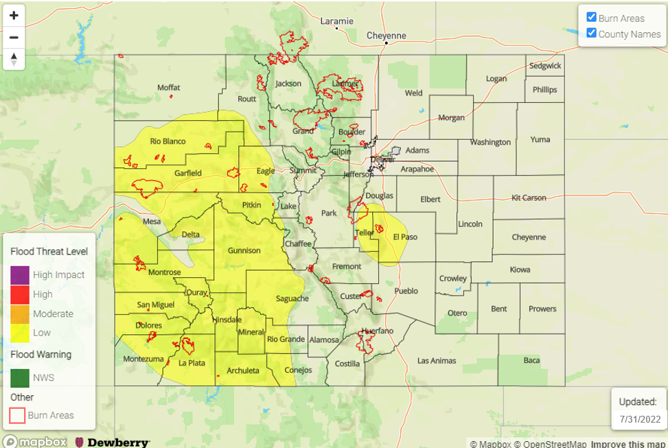
— Fire-Burn Forecast Summary: 4 burn areas under MODERATE flood threat; 5 burn areas under LOW threat; click HERE for more info
The last day of July will close on a very similar note as the rest of the month: plenty of moisture remains somewhere across Colorado to force a heavy rainfall threat! Looking at the visible satellite image, below, a split flow pattern continues across the Four Corners. A residual disturbance from last night’s storm activity remains along the NM border, and will act as a bit of a focal point for additional storms today. The monsoonal ridge will intensify today, and build northwestward towards Utah. This will promote warmer temperatures east of the Continental Divide, along with lower rainfall chances. To the west, plenty of moisture remains stuck “under” the ridge. PW this morning at Grand Junction came in 1.10 inches, well above normal for this time of year. Furthermore, the lower levels of the atmosphere were quite moist and prime for heavy rainfall generation. PW in the 0.9 – 1.2 range will be expected for western Colorado. With plenty of sunshine expected, instability up to 900 J/kg CAPE and very slow storm motion will suffice for supporting scattered showers and storms during the afternoon and evening hours along and west of the Continental Divide. However, with the building ridge, expect slightly reduced coverage overall compared to yesterday along with a preference for staying over the higher terrain. Thus, yesterday’s Moderate threat will be bumped down to a LOW to account for 30-60 minutes of heavy rainfall potential and associated threat of excessive runoff.
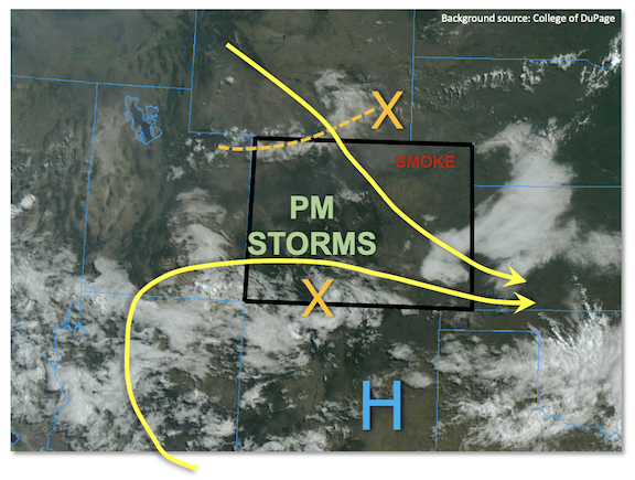
To the east of the Continental Divide, some recovery in moisture has occurred with PW at the Platteville research station at around 0.77 inches (just below seasonal normal). A disturbance along the WY border will skirt ESE into Colorado this afternoon, setting the focal point for widely scattered showers and storms. With quicker steering flow expected later this afternoon, these storms will pose more of a gusty wind threat although brief moderate/heavy rainfall will occur. Further south, however, with more moisture noted this morning along the Palmer Ridge in the Pikes Peak region, a LOW flood threat is warranted for this climatologically favored area as storms could anchor to the terrain just long enough to cause a 60 minute heavy rainfall threat.
Today’s Flood Threat Map
For more information on today’s flood threat, see the map below. If there is a threat, hover over the threat areas for more details, and click on burn areas to learn more about them. For Zone-Specific forecasts, scroll below the threat map.
Zone-Specific Forecasts:
Northern Mountains, Central Mountains, Grand Valley, San Juan Mountains, Southwest Slope, San Luis Valley & Northwest Slope:
Mostly sunny early then scattered to numerous showers and storms this afternoon and evening. Highest coverage will be over higher terrain, above 7,500 feet. Max 30-min rain rates up to 1.0 inches, with max 1-hour rainfall up to 1.5 inches warrants a LOW flood threat for isolated flash flooding, debris slides and mud flows. Gusty winds will also be possible, especially over northern areas.
Primetime: 12PM through 9PM
Northeast Plains, Southeast Plains, Front Range, Urban Corridor, Palmer Ridge, Southeast Mountains & Raton Ridge:
Mostly sunny and warmer with isolated to widely scattered showers and storms expected this afternoon and evening. For most areas, max 30-minute rainfall up to 0.6 inches is NOT expected to cause flooding. However, for the climatologically preferred region around Pikes Peak, a LOW flood threat has been posted where max 1-hour rainfall up to 1.5 inches is possible this afternoon before storms move eastward. Gusty winds up to 40 mph will be possible with the strongest storms.
Primetime: 1PM to 8PM