Issue Date: Friday, July 29th, 2022
Issue Time: 10:45AM MDT
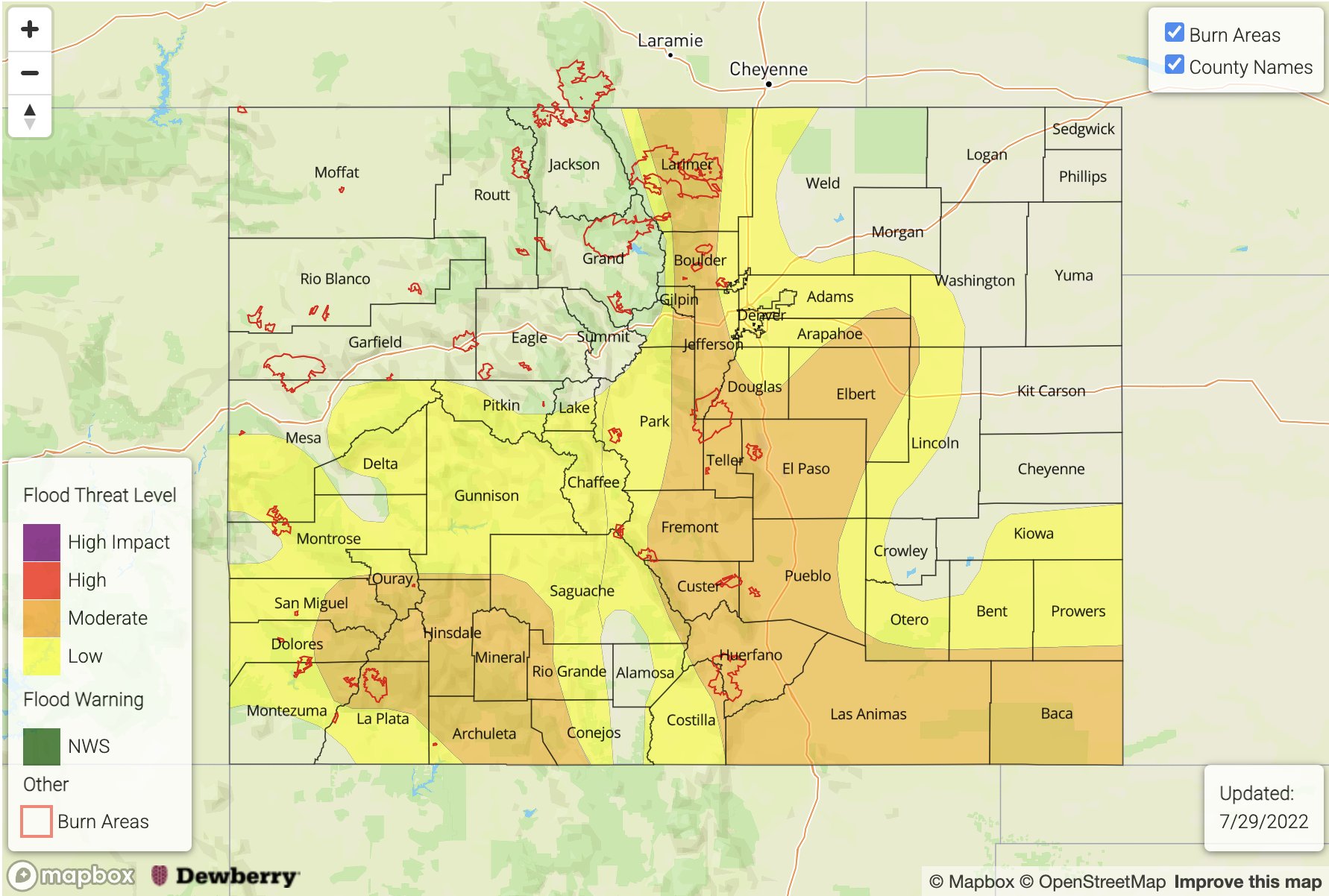
— A MODERATE flood threat has been issued for the Front Range, Southeast Mountains, Raton Ridge and portions of the Southwest Slope, Urban Corridor, Palmer Ridge and Southeast Plains
— A LOW flood threat has been issued for the Central Mountains, Grand Valley and portions of the Northeast Plains and San Luis Valley
— Fire-Burn Forecast Summary: 2 burn area under HIGH threat, 3 burn areas under MODERATE threat, 6 burn areas under LOW threat; click HERE for more info
Monsoon moisture remains over the state with little overall change to the synoptic pattern from yesterday. Westerly flow across the southern border continues to pull in the subtropical plume, and mixed with some mid-level and orographic lift, is producing lots of cloud cover and rainfall already this morning. PW at Grand Junction was measured at 1.07 inches with values increasing to 1.2 inches towards Albuquerque, New Mexico. PW at Montrose was measured at 0.92 inches, so as expected, high moisture has made its way into the mountain valleys. Over eastern Colorado, PW at Platteville was measured at 1.1 inches with dew points over northeast Colorado in the 60°Fs. With NNW steering flow (east) and SSW steering flow (southwest) remaining slower, plenty of moisture in the lower portion of the atmosphere and a decent warm layer, the threat for heavy rainfall continues.
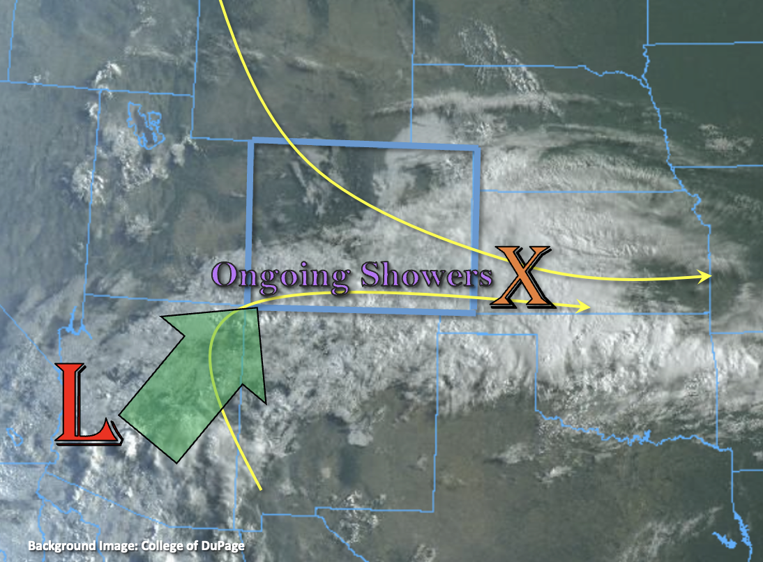
Ongoing cloud cover and already moderate rainfall could inhibit the convective threat somewhat today over southwest Colorado. However, soils are saturated over portions of the San Juan Mountains, which is best demonstrated by the peak in streamflow in the San Juan River at Pagosa Springs where flow jumped from 140 cfs to 1450 cfs overnight. There will still be an isolated 30-minute threat for convection if breaks in cloud cover occur, and with storm totals up to 2.25 inches possible and widespread totals between 1.5-2 inches forecast, a MODERATE flood threat has been issued. Over eastern Colorado, breaks in cloud cover along the Front Range indicate that stronger storms will be possible by this afternoon as upslope flow kicks in. In addition to mountain storms, over the Palmer Ridge it is likely that a convergence zone will set up, which could help produce some stronger thunderstorms. With slow SSE storm movement forecast, a MODERATE flood threat has been issued. Finally, across southeast Colorado, ongoing showers are likely to intensify over the eastern plains with upslope flow and mid-level energy helping to spark additional scattered storms over the Southeast Mountains. A MODERATE flood threat has been issued as soils over portions this region are likely saturated as well. Flood threats today include isolated mud flows and debris slides over steeper terrains, increased runoff causing rises in local rivers/creeks (south), and under stronger thunderstorm cores that develop, road flooding and field ponding.
Today’s Flood Threat Map
For more information on today’s flood threat, see the map below. If there is a threat, hover over the threat areas for more details, and click on burn areas to learn more about them. For Zone-Specific forecasts, scroll below the threat map.
Zone-Specific Forecasts:
Southwest Slope, San Luis Valley, Southeast Mountains, Raton Ridge, Southeast Plains, & San Juan Mountains:
Saturated soils are likely to cause an increase in runoff this afternoon, so rises on local streams, creeks and rivers should be expected where moderate to intense showers and thunderstorms set up. In addition to heavy rainfall, storms may produce some hail and strong winds, especially over eastern Colorado. For western Colorado, max 30-minute rain rates up to 1 inch and storm totals up to 2.25 inches will be possible. Over eastern Colorado, max 1-hour rain rates up to 1.75 inches over the Southeast Mountains and adjacent plains will be possible with max 3-hour rain rates up to 4 inches possible over the far eastern plains. Additional flood threats include road flooding and fielding ponding under stronger thunderstorms. A MODERATE flood threat has been issued. Showers may linger over the plains into the morning hours, but the flood threat should wind down between 10-11PM.
Primetime: 11AM to 1AM
Northwest Slope, Northern Mountains, Central Mountains, Grand Valley, Urban Corridor, Front Range, Palmer Ridge & Northeast Plains:
Over northwest Colorado, storms should be more isolated with max 1-hour rain rates up to 0.9 inches possible. More widespread rainfall is forecast over the other mountains zones with max 1-hour rain rates up to 1.75 inches possible. Over the Palmer Ridge, a couple stronger thunderstorms are possible, which could produce hail, strong outflow winds and max 1-hour rain rates up to 2.5 inches. Flood threats today include the possibility of isolate mud flows and debris slides over steeper terrains as well as road flooding, field ponding and rises in local streams/creeks across the lower elevations. A MODERATE flood threat has been issued.
Primetime: 12PM to 11PM