Issue Date: Saturday, July 30th, 2022
Issue Time: 10AM MDT
— A MODERATE flood threat has been issued for parts of the Central Mountains, Grand Valley, Southwest Slope and San Juan Mountains
— A LOW flood threat has been issued for parts of the Southeast Mountains
— Fire-Burn Forecast Summary: 2 burn areas under MODERATE threat; 4 burn areas under LOW threat; click HERE for more info
After a prolonged stretch of moist and rainy weather basically statewide, a pulse of significant drier air has entered northeast Colorado (visible satellite image, below) for this last weekend of July. In this region, PW has fallen sharply from over 1 inch yesterday morning to about 0.6 inches this morning. Mainly dry weather is expected for the northeast quadrant of our state today.
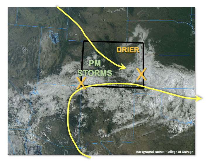
It is a much different story further south and west as plenty of monsoonal moisture remains. Grand Junction’s morning PW is up to 1.17 inches with moisture well distributed across the entire atmospheric column. PW as high as 1.3 inches is estimated currently over far southwest Colorado, stretching eastward along the NM border. Dynamics wise, the split flow pattern continues over Colorado. However, with the aforementioned drying from the north, the northwesterly flow has pushed further south today. Clockwise W/SW flow remains across western and southern Colorado, associated with the monsoonal ridge to the southeast. Two disturbances were noted this morning. The first, associated with yesterday’s storms, is currently moving eastward into KS. It will promote subsidence behind it, suppressing storms for most of eastern Colorado, aside from far southern areas. To the west, a monsoonal disturbance is associated with a hefty cloud deck along with some spotty light showers. It is this feature that will be the focal point of today’s flood threat. Around the periphery of cloudiness, we expect intermittent sunshine to boost instability towards 1,000 – 1,400 J/kg CAPE. With weak steering flow, mainly shorter-term heavy rainfall is expected across a large swath of the western higher terrain. A MODERATE/LOW flood threat is warranted for mainly the 30-60 minute duration. Along the NM border over southeast Colorado, a more conditional flood threat exists because of the aforementioned subsidence. Isolated to widely scattered storms are possible this afternoon, and with significant instability (exceeding 2,500 J/kg CAPE), very heavy rainfall will be possible along with a risk of severe weather. A LOW flood threat is warranted here. Unlike previous days, most rainfall activity should subside within a few hours of sunset.
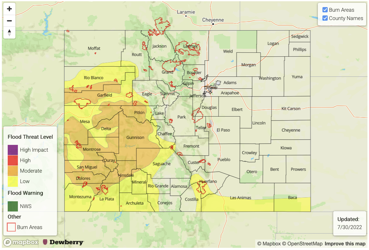
Today’s Flood Threat Map
For more information on today’s flood threat, see the map below. If there is a threat, hover over the threat areas for more details, and click on burn areas to learn more about them. For Zone-Specific forecasts, scroll below the threat map.
Zone-Specific Forecasts:
Northern Mountains, Central Mountains, Grand Valley, San Juan Mountains, Southwest Slope, San Luis Valley, Southeast Mountains & Northwest Slope:
Partly to mostly cloudy this morning with some light showers continuing over southern areas. By early afternoon, scattered to numerous thunderstorms are expected over most of the higher terrain. Best coverage will be over central and southern areas. Max 30-min rainfall up to 0.9 inches (north) and 1.4 inches (south), with max 1-hour rainfall up to 2.0 inches possible. A MODERATE/LOW flood threat has been posted for isolated flash flooding, debris slides and mud flows. Over southern areas where soils are saturated, minor flooding of smaller creeks and streams is possible.
Primetime: 12PM to 11PM
Raton Ridge & Southeast Plains:
Partly cloudy early then some clearing with isolated to widely scattered storms expected this afternoon and evening. The strongest storms could produce up to 2.8 inches of rainfall in 1 hour, warranting a LOW flood threat for isolated flash flooding and arroyo flooding. Mud flows and debris slides will be possible over steeper terrain.
Primetime: 3PM to 10PM
Northeast Plains, Front Range, Urban Corridor & Palmer Ridge:
Becoming mostly sunny and warmer today. Isolated thunderstorms are possible, mainly for elevations above 6,500 feet. Max 30-min rainfall up to 0.5 inches is possible but flooding is NOT expected today.
Primetime: 12PM to 8PM