FTB 06-18-2020: Flood Threat Returns to Southeast Colorado

Issue Date: Thursday, June 18th, 2020
Issue Time: 10:15AM MDT

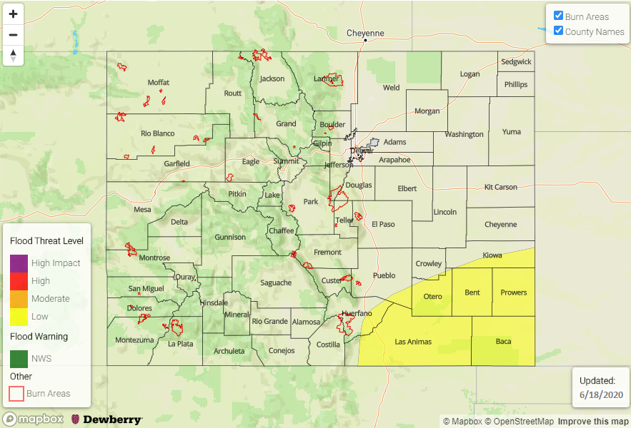
— A LOW flood threat has been issued for the Southeast Plains and Raton Ridge

Afternoon update: Updated the guidance, and it shows an overall decrease in the heavy rainfall threat overnight. However, one hour rain rates up to 1 inch will still be possible over the western Raton Ridge area due to a surge in the low level moisture. Thus, the Low flood threat will continue, but realize that it is more for the western portion of the threat area and the overall totals have slightly dropped. 

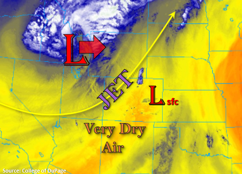
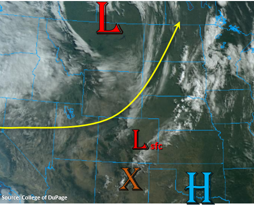
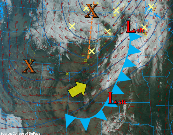
Much cooler temperatures to start the day behind the gusty cold front that passed through yesterday evening and overnight. It has cooled things off quite a bit, and highs today should be 10-15F lower than yesterday. The main Low pressure system is currently to our north, and another shortwave is to our west over Nevada/Utah (orange “X”). Southwest flow aloft will continue today with the jet stream located over the eastern plains. The approaching shortwave will combine with the right entrance region of this jet later this evening creating a large area of lift over the Southeast Plains and Raton Ridge into tomorrow morning.

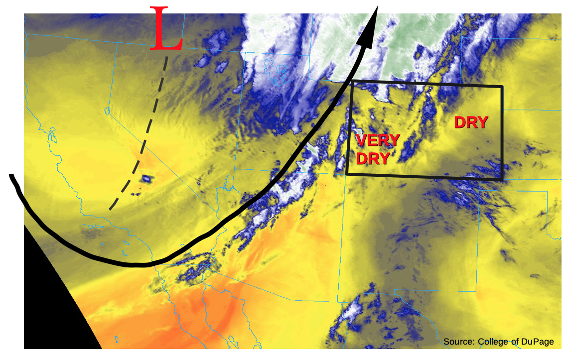
The next ingredient needed for rainfall is moisture. PW has increased to a half inch over Denver and 0.44 inches over Grand Junction. Dry southwest flow should scour out this low-level moisture west of the Continental Divide, so rainfall is not forecast today. However, over the eastern half of Colorado, enough moisture should hang around for afternoon storms to form over the Front Range and Palmer Ridge with afternoon upslope flow. Storms for the most part will remain stationary, but are expected to increase in intensity and spill into the adjacent plains later this evening into the overnight hours as the shortwave arrives. These storms should only produce moderate 1-hour rainfall rates, so flooding is not forecast for this area.

Over the Southeast Plains and Raton Ridge, PW values ramp up and will be near and exceed 1 inch by later tonight. A thunderstorm or two is possible this evening as the shortwave arrives before instability drops off with the setting sun. Storms are expected to continue, and increase in coverage, over these regions tonight due to the aforementioned elements providing a large area of lift through tomorrow morning. Some guidance is hinting at one to two hour totals from the trailing storms nearing 2 inches due to very strong lift from the shortwave. A Low flood threat has been issued for this reason with possible threats being arroyo flooding, small stream flooding, and field ponding. An afternoon update will be issued if the overnight flooding threat decreases.

Today’s Flood Threat Map

For more information on today’s flood threat, see the map below. If there is a threat, hover over the threat areas for more details, and click on burn areas to learn more about them. For Zone-Specific forecasts, scroll below the threat map.

Zone-Specific Forecasts:

Southeast Plains & Raton Ridge:

A couple severe storms will be possible early this evening with the main threats being small hail and gusty winds. Storms should increase in coverage later tonight due to lift and moisture in the area, and rainfall is expected to continue through tomorrow morning. Totals up to 2 inches will be possible with trailing storms, so a Low flood threat has been issued for these evening and overnight storms. Threats would include small stream flooding, road flooding, field ponding, and arroyo flooding. An afternoon update will be issued if the threat drops off as some high-resolution guidance is not indicating as strong of lift over the area.

Primetime: 7PM to 9AM

Front Range, Southeast Mountains, Northeast Plains, Urban Corridor, & Palmer Ridge:

Expecting storms to form over the Front Range and Palmer Ridge by early afternoon. Less moisture is forecast over the Southeast Mountains, which means storms will be high-based with little rainfall. Storms should expand in coverage as the shortwave arrives this evening and spill into the adjacent plains with the increasing southwest steering flow. Some claps of thunder may also be possible before instability decreases after sundown. Max 1-hour rain rates up to 0.60 inches will be possible (west) and 0.50 inches (east). Lingering rainfall over the central Front Range into tomorrow morning is expected to produce totals just over 1 inch. Due to the more gradual nature of the rainfall and dry soils, flooding is not expected.

Primetime: 1PM to 9AM

Central Mountains, San Juan Mountains, Northern Mountains, Northwest Slope, Grand Valley, San Luis Valley, & Southwest Slope:

It’s going to be dry over these regions with highs a lot cooler (10-15F) than the last few days. Southwest surface winds in the San Luis Valley are forecast to be in the 10 to 20 mph range with gusts up to 30 mph. Paired with dry southwesterly flow (low relative humidity values), a Red Flag Warning has been issued. A weaker gradient over western Colorado should reduce the fire danger, although fuels remain very dry. Haze from wildfires will continue to cause low air quality and limited visibility.

FTB 06-17-2020: One More Day of Hot Temperatures and High Fire Danger

Issue Date: Wednesday, June 17th, 2020
Issue Time: 8:45AM MDT

— Flooding is NOT expected today

More of the same today with windy and dry conditions forecast. The upper level jet is in position over western and central Colorado as the Low approaches from the west, which will help create high surface winds and entrainment of dry air from the southwest/west. To the east, another lee cyclone will develop, which will lead to high surface winds over the eastern plains. With little to no low-level moisture over the state, only broken cloud cover is forecast this afternoon and evening. Low relative humidity values and increasing surface winds will also mean that a large portion of the state will remain under a Red Flag Warning or elevated fire danger. Hang in there, change is on its way!

There is a cold front approaching Colorado that will arrive to the Northwest Slope and Northern Mountains very soon. This will help keep fire danger lower over that area this afternoon and knock down high temperatures a few degrees. The front will push south later this evening across the entire state, which will bring some gusty, northerly winds to the eastern plains. The front does not have a lot of moisture along it, so rainfall will be unlikely. However, expect the surface temperatures to drop significantly behind it, and highs tomorrow will be, more or less, ~10-15F cooler. Personally, I’m very much looking forward to this.

Today’s Flood Threat Map

For more information on today’s flood threat, see the map below. If there is a threat, hover over the threat areas for more details, and click on burn areas to learn more about them. For Zone-Specific forecasts, scroll below the threat map.

Zone-Specific Forecasts:

Front Range, Southeast Mountains, Raton Ridge, Southeast Plains, Northeast Plains, Urban Corridor, San Luis Valley, & Palmer Ridge:

High temperatures will be similar to yesterday, so it’s going to be hot! Rainfall is not forecast this afternoon, but some broken cloud cover over is likely over the mountains and I-25 corridor. Critical and elevated fire weather remains present for most of these regions as well, so tune into your local NWS office for the latest. As the aforementioned cold front pushes south tonight, expect wind gusts up to 55 mph over the eastern plains with more general gusts in the 30 to 40 mph range. Flooding is not forecast.

Central Mountains, San Juan Mountains, Northern Mountains, Northwest Slope, Grand Valley, & Southwest Slope:

Cooler temperatures are forecast for the Northwest Slope and Northern Mountains as the front arrives by later this morning. This should help decrease fire danger over the area. Further south, temperatures will be similar to yesterda,y and the fire danger remains critical. Hazy conditions are forecast near the southern border with the fires in the area. Please use caution when operating anything that could cause a spark, and tune into NWS Grand Junction for the latest on the Red Flag Warning.

FTB 06-16-2020: Very Hot and Mainly Dry Today with an Elevated Fire Threat for Many

Issue Date: Tuesday, June 16th, 2020
Issue Time: 9AM MDT

— Flooding is NOT expected today

This morning’s water vapor imagery, shown below, shows a rather strong upper-level trough approaching Colorado. Unfortunately, as described in yesterday’s Flood Threat Outlook, it has a very limited amount of moisture to work with as it moves eastward. Precipitable water (PW) at Grand Junction this morning was a meager 0.20 inches, with Denver at 0.42 inches. Even across eastern Colorado, PW was well below 1.0 inch. Thus, expect mainly diurnally driven clouds across the central and southern higher terrain, with isolated showers and storms limited to the Southeast Mountains, Raton Ridge and Southeast Plains this afternoon. Gusty winds will be the biggest threat with any storm that does develop and flooding is not expected today. It will also be very hot statewide, but especially east of the Continental Divide. This morning’s 700mb temperature (about 5,000 ft above ground level) from the Denver sounding was 61F, which is close to a record for mid-June. Thus, expect high temperatures to be 10-15F above normal.

By far the bigger story today will be the threat of wildfires. A Red Flag warning has been issued for the almost the entire state, save for a small portion of north-central Colorado. Afternoon sustained winds of 20-25 mph are likely, with much higher gusts especially over the Northwest Slope. To stay updated on the latest fire conditions, check out local National Weather Service forecasts and discussion, and the #COfire thread on Twitter.

Today’s Flood Threat Map

For more information on today’s flood threat, see the map below. If there is a threat, hover over the threat areas for more details, and click on burn areas to learn more about them. For Zone-Specific forecasts, scroll below the threat map.

Zone-Specific Forecasts:

Northeast Plains, Front Range, Palmer Ridge, Urban Corridor:

Mostly sunny early then partly cloudy during the afternoon. Windy and very hot with lower elevations approaching 100F (below 4,500 feet). Parts of the area are under a Red Flag warning for the threat of wildfires.

Flooding is not expected today.

Central Mountains, Northwest Slope, Grand Valley, Northwest Slope, Southwest Slope, San Juan Mountains, San Luis Valley:

Partly cloudy, hot and very windy today. Afternoon wind gusts exceeding 50mph are likely across northeast facing slopes. A Red Flag warning is in effect today for the threat of wildfires.

Flooding is not expected today.

Southeast Mountains, Raton Ridge, Southeast Plains:

Mostly sunny early then partly cloudy during the afternoon. Isolated showers and thunderstorms are possible. Max 1-hour rainfall up to 0.5 inches, mainly across eastern areas. Otherwise, windy and very hot with lower elevations approaching 100-105F. Parts of the area are under a Red Flag warning for the threat of wildfires.

Flooding is not expected today.

FTB 06-15-2020: Another Hot, Dry Day Ahead

Issue Date: Monday, June 15th, 2020
Issue Time: 8:55AM MDT

— Flooding is NOT expected today

It’s going to be a hot and dry day across the state again. The Low that has been affecting the state over the last few days is now to our north near the Montana/Canadian border. So, the clouds over the Southeast Plains, associated with this system, are forecast to mix out and move eastward throughout the morning. Southwest flow aloft will continue to pull in a dry air mass, so there won’t be moisture around for afternoon showers over the mountains. The best chance for a little rain will be over the far Southeast Plains/Raton Ridge where disturbances moving around the high will combine with daytime heating and minimal moisture (orange “X”). Storms that are able to form will once again be high-based, so more wind gusts (up to 30 to 40 mph) are likely than rainfall. Flooding is not expected.

As for critical fire weather, a developing lee cyclone (shown below) should increase surface winds over the far Southeast Plains, which will most like help create Red Flag Warning criteria this afternoon. The lower elevations back west (western border and San Luis Valley) will also have some gusty winds between the system to our north and approaching system to our west. Fire weather will be more hit or miss in these areas, but nonetheless, the threat remains elevated. Tune into your local NWS for the latest on Red Flag Warnings.

Today’s Flood Threat Map

For more information on today’s flood threat, see the map below. If there is a threat, hover over the threat areas for more details, and click on burn areas to learn more about them. For Zone-Specific forecasts, scroll below the threat map.

Zone-Specific Forecasts:

Front Range, Southeast Mountains, Raton Ridge, Southeast Plains, Northeast Plains, Urban Corridor, & Palmer Ridge:

It’s going to be hot again with only limited cloud cover developing this afternoon. There’s some mid-level moisture over the Front Range and Northern Mountains associated with a very weak cold front, so these areas will have the best chance for some relief from the heat this afternoon (cloud cover). Highs will reach the mid to upper 90Fs over the Urban Corridor with highs 15-20F cooler in the mountain valleys. The far Southeast Plains could reach 100F. If storms are able to develop over the far Southeast Plains, storm totals up to 0.25 inches will be possible. Flooding is not forecast.

Primetime: 2PM to 10PM

Central Mountains, San Juan Mountains, Northern Mountains, Northwest Slope, Grand Valley, San Luis Valley, & Southwest Slope:

It’s going to be even more dry over these regions, although some broken cloud cover is possible for the Northwest Slope and Northern Mountains. With a weak jet dipping south from the current system and the approaching jet from the next system to our west, there’s a good chance for gusty winds over these regions again this afternoon. High surface winds are not expected to be as widespread as yesterday, so only enhanced fire weather is forecast. Tune into NWS Pueblo and Grand Junction of the latest on the Red Flag Warnings issued.