Issue Date: Monday, June 15th, 2020
Issue Time: 8:55AM MDT
— Flooding is NOT expected today
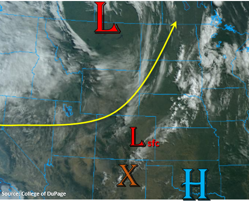
It’s going to be a hot and dry day across the state again. The Low that has been affecting the state over the last few days is now to our north near the Montana/Canadian border. So, the clouds over the Southeast Plains, associated with this system, are forecast to mix out and move eastward throughout the morning. Southwest flow aloft will continue to pull in a dry air mass, so there won’t be moisture around for afternoon showers over the mountains. The best chance for a little rain will be over the far Southeast Plains/Raton Ridge where disturbances moving around the high will combine with daytime heating and minimal moisture (orange “X”). Storms that are able to form will once again be high-based, so more wind gusts (up to 30 to 40 mph) are likely than rainfall. Flooding is not expected.
As for critical fire weather, a developing lee cyclone (shown below) should increase surface winds over the far Southeast Plains, which will most like help create Red Flag Warning criteria this afternoon. The lower elevations back west (western border and San Luis Valley) will also have some gusty winds between the system to our north and approaching system to our west. Fire weather will be more hit or miss in these areas, but nonetheless, the threat remains elevated. Tune into your local NWS for the latest on Red Flag Warnings.
Today’s Flood Threat Map
For more information on today’s flood threat, see the map below. If there is a threat, hover over the threat areas for more details, and click on burn areas to learn more about them. For Zone-Specific forecasts, scroll below the threat map.

Zone-Specific Forecasts:
Front Range, Southeast Mountains, Raton Ridge, Southeast Plains, Northeast Plains, Urban Corridor, & Palmer Ridge:
It’s going to be hot again with only limited cloud cover developing this afternoon. There’s some mid-level moisture over the Front Range and Northern Mountains associated with a very weak cold front, so these areas will have the best chance for some relief from the heat this afternoon (cloud cover). Highs will reach the mid to upper 90Fs over the Urban Corridor with highs 15-20F cooler in the mountain valleys. The far Southeast Plains could reach 100F. If storms are able to develop over the far Southeast Plains, storm totals up to 0.25 inches will be possible. Flooding is not forecast.
Primetime: 2PM to 10PM
Central Mountains, San Juan Mountains, Northern Mountains, Northwest Slope, Grand Valley, San Luis Valley, & Southwest Slope:
It’s going to be even more dry over these regions, although some broken cloud cover is possible for the Northwest Slope and Northern Mountains. With a weak jet dipping south from the current system and the approaching jet from the next system to our west, there’s a good chance for gusty winds over these regions again this afternoon. High surface winds are not expected to be as widespread as yesterday, so only enhanced fire weather is forecast. Tune into NWS Pueblo and Grand Junction of the latest on the Red Flag Warnings issued.