Issue Date: Wednesday, June 17th, 2020
Issue Time: 8:45AM MDT
— Flooding is NOT expected today
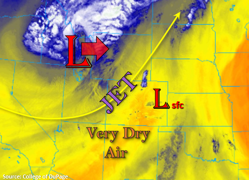
More of the same today with windy and dry conditions forecast. The upper level jet is in position over western and central Colorado as the Low approaches from the west, which will help create high surface winds and entrainment of dry air from the southwest/west. To the east, another lee cyclone will develop, which will lead to high surface winds over the eastern plains. With little to no low-level moisture over the state, only broken cloud cover is forecast this afternoon and evening. Low relative humidity values and increasing surface winds will also mean that a large portion of the state will remain under a Red Flag Warning or elevated fire danger. Hang in there, change is on its way!
There is a cold front approaching Colorado that will arrive to the Northwest Slope and Northern Mountains very soon. This will help keep fire danger lower over that area this afternoon and knock down high temperatures a few degrees. The front will push south later this evening across the entire state, which will bring some gusty, northerly winds to the eastern plains. The front does not have a lot of moisture along it, so rainfall will be unlikely. However, expect the surface temperatures to drop significantly behind it, and highs tomorrow will be, more or less, ~10-15F cooler. Personally, I’m very much looking forward to this.
Today’s Flood Threat Map
For more information on today’s flood threat, see the map below. If there is a threat, hover over the threat areas for more details, and click on burn areas to learn more about them. For Zone-Specific forecasts, scroll below the threat map.

Zone-Specific Forecasts:
Front Range, Southeast Mountains, Raton Ridge, Southeast Plains, Northeast Plains, Urban Corridor, San Luis Valley, & Palmer Ridge:
High temperatures will be similar to yesterday, so it’s going to be hot! Rainfall is not forecast this afternoon, but some broken cloud cover over is likely over the mountains and I-25 corridor. Critical and elevated fire weather remains present for most of these regions as well, so tune into your local NWS office for the latest. As the aforementioned cold front pushes south tonight, expect wind gusts up to 55 mph over the eastern plains with more general gusts in the 30 to 40 mph range. Flooding is not forecast.
Central Mountains, San Juan Mountains, Northern Mountains, Northwest Slope, Grand Valley, & Southwest Slope:
Cooler temperatures are forecast for the Northwest Slope and Northern Mountains as the front arrives by later this morning. This should help decrease fire danger over the area. Further south, temperatures will be similar to yesterda,y and the fire danger remains critical. Hazy conditions are forecast near the southern border with the fires in the area. Please use caution when operating anything that could cause a spark, and tune into NWS Grand Junction for the latest on the Red Flag Warning.