Issue Date: Thursday, June 18th, 2020
Issue Time: 10:15AM MDT
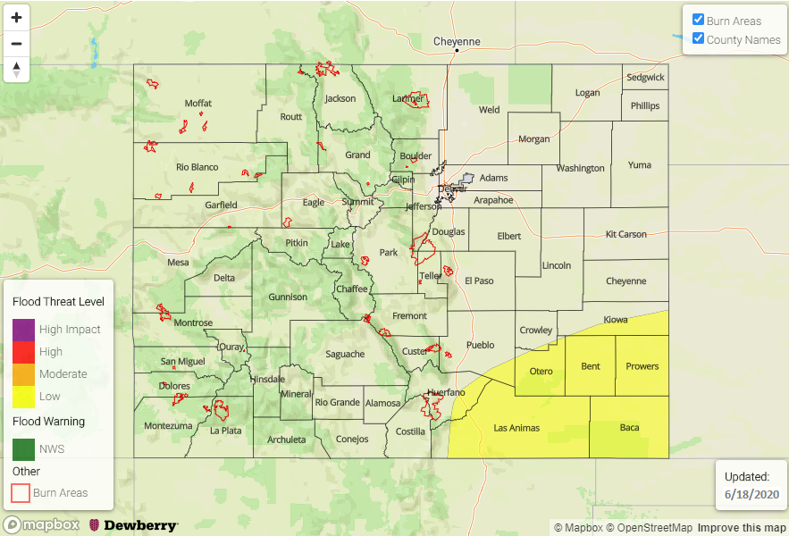
— A LOW flood threat has been issued for the Southeast Plains and Raton Ridge
Afternoon update: Updated the guidance, and it shows an overall decrease in the heavy rainfall threat overnight. However, one hour rain rates up to 1 inch will still be possible over the western Raton Ridge area due to a surge in the low level moisture. Thus, the Low flood threat will continue, but realize that it is more for the western portion of the threat area and the overall totals have slightly dropped.
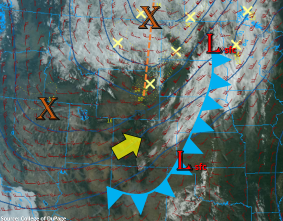
Much cooler temperatures to start the day behind the gusty cold front that passed through yesterday evening and overnight. It has cooled things off quite a bit, and highs today should be 10-15F lower than yesterday. The main Low pressure system is currently to our north, and another shortwave is to our west over Nevada/Utah (orange “X”). Southwest flow aloft will continue today with the jet stream located over the eastern plains. The approaching shortwave will combine with the right entrance region of this jet later this evening creating a large area of lift over the Southeast Plains and Raton Ridge into tomorrow morning.

The next ingredient needed for rainfall is moisture. PW has increased to a half inch over Denver and 0.44 inches over Grand Junction. Dry southwest flow should scour out this low-level moisture west of the Continental Divide, so rainfall is not forecast today. However, over the eastern half of Colorado, enough moisture should hang around for afternoon storms to form over the Front Range and Palmer Ridge with afternoon upslope flow. Storms for the most part will remain stationary, but are expected to increase in intensity and spill into the adjacent plains later this evening into the overnight hours as the shortwave arrives. These storms should only produce moderate 1-hour rainfall rates, so flooding is not forecast for this area.
Over the Southeast Plains and Raton Ridge, PW values ramp up and will be near and exceed 1 inch by later tonight. A thunderstorm or two is possible this evening as the shortwave arrives before instability drops off with the setting sun. Storms are expected to continue, and increase in coverage, over these regions tonight due to the aforementioned elements providing a large area of lift through tomorrow morning. Some guidance is hinting at one to two hour totals from the trailing storms nearing 2 inches due to very strong lift from the shortwave. A Low flood threat has been issued for this reason with possible threats being arroyo flooding, small stream flooding, and field ponding. An afternoon update will be issued if the overnight flooding threat decreases.
Today’s Flood Threat Map
For more information on today’s flood threat, see the map below. If there is a threat, hover over the threat areas for more details, and click on burn areas to learn more about them. For Zone-Specific forecasts, scroll below the threat map.

Zone-Specific Forecasts:
Southeast Plains & Raton Ridge:
A couple severe storms will be possible early this evening with the main threats being small hail and gusty winds. Storms should increase in coverage later tonight due to lift and moisture in the area, and rainfall is expected to continue through tomorrow morning. Totals up to 2 inches will be possible with trailing storms, so a Low flood threat has been issued for these evening and overnight storms. Threats would include small stream flooding, road flooding, field ponding, and arroyo flooding. An afternoon update will be issued if the threat drops off as some high-resolution guidance is not indicating as strong of lift over the area.
Primetime: 7PM to 9AM
Front Range, Southeast Mountains, Northeast Plains, Urban Corridor, & Palmer Ridge:
Expecting storms to form over the Front Range and Palmer Ridge by early afternoon. Less moisture is forecast over the Southeast Mountains, which means storms will be high-based with little rainfall. Storms should expand in coverage as the shortwave arrives this evening and spill into the adjacent plains with the increasing southwest steering flow. Some claps of thunder may also be possible before instability decreases after sundown. Max 1-hour rain rates up to 0.60 inches will be possible (west) and 0.50 inches (east). Lingering rainfall over the central Front Range into tomorrow morning is expected to produce totals just over 1 inch. Due to the more gradual nature of the rainfall and dry soils, flooding is not expected.
Primetime: 1PM to 9AM
Central Mountains, San Juan Mountains, Northern Mountains, Northwest Slope, Grand Valley, San Luis Valley, & Southwest Slope:
It’s going to be dry over these regions with highs a lot cooler (10-15F) than the last few days. Southwest surface winds in the San Luis Valley are forecast to be in the 10 to 20 mph range with gusts up to 30 mph. Paired with dry southwesterly flow (low relative humidity values), a Red Flag Warning has been issued. A weaker gradient over western Colorado should reduce the fire danger, although fuels remain very dry. Haze from wildfires will continue to cause low air quality and limited visibility.