SPM 07-27-2020: Monsoon Rains Soak Southeastern Colorado & the Southern San Juan Mountains

Issue Date: Monday, July 27th, 2020
Issue Time: 10:55AM MDT

Summary:

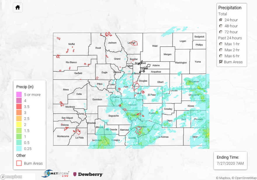
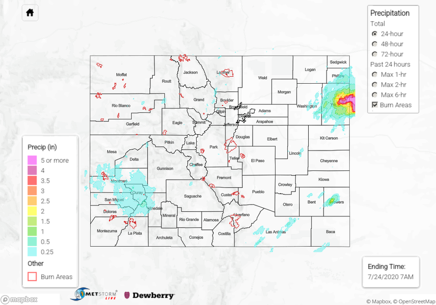
Heavy rain fell over the southern half of Colorado, which brought significant 24-hour rain totals for the southern San Juan Mountains, Southeast Mountains, and portions of the Palmer Ridge and Southeast/Northeast Plains. Today’s QPE map shows 24-hour rain totals reached up to 2 inches over the southern San Juan Mountains. The highest rain gauge report in this area was 1.76 inch from a CoCoRaHS observer over southeastern Archuleta County. Several other rain gauges in the area southeast of the town of Pagosa Springs picked up around 1.4 inch. No flooding was reported in the area, but a CoCoRaHS observer near Pagosa Springs mentioned that drainages were full.

Storms were able to fire over the Southeast Mountains by noon yesterday, which lingered over the area well into the overnight hours (ending ~ 3AM MDT). Some of these storms caused flash flooding near the Decker and Spring Creek burn areas. Storms over the Decker burn area produced up to 2 inches of rain over a couple hours according to an ASOS station near the burn area. This heavy rain caused a county road to be washed out by flash flooding of the Bear Creek just south of Salida, CO, and caused flooding in a home. Storms over the Spring Creek burn area dropped up to 1.79 inch of rain, indicated by a USGS rain gauge along the southwestern portion of Huerfano County. QPE generally agrees with observations in the area and shows 1+ inch of rain fell over eastern portions of the Spring Creek burn area. A flash flood was reported along Colorado highway 12 in southwestern Huerfano County. Many other locations along and just east of the Southeast Mountains saw heavy rain yesterday, with numerous 24-hour rain reports over 1 inch in Huerfano and Custer counties. Take a look at today’s QPE map below.

The plains of eastern Colorado did not miss out on heavy rain yesterday. The strongest storms were able to develop over Kit Carson and Cheyenne counties, where a couple severe thunderstorm warnings were issued. The highest 24-hour rain total was 2.21 inches from a CoCoRaHS station in far eastern Cheyenne County. A couple of ASOS stations in central Kit Carson County also picked up just over 2 inches of rain from storms in the area. The QPE map appears to agree with these maxima in rain accumulations just over 2 inches, and it shows the isolated nature of these higher rain totals. These severe storms also dropped up to dime size hail. Even though heavy rain was reported by many stations in this area, no flooding was reported.

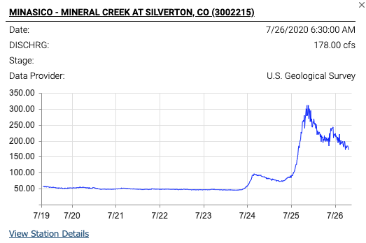
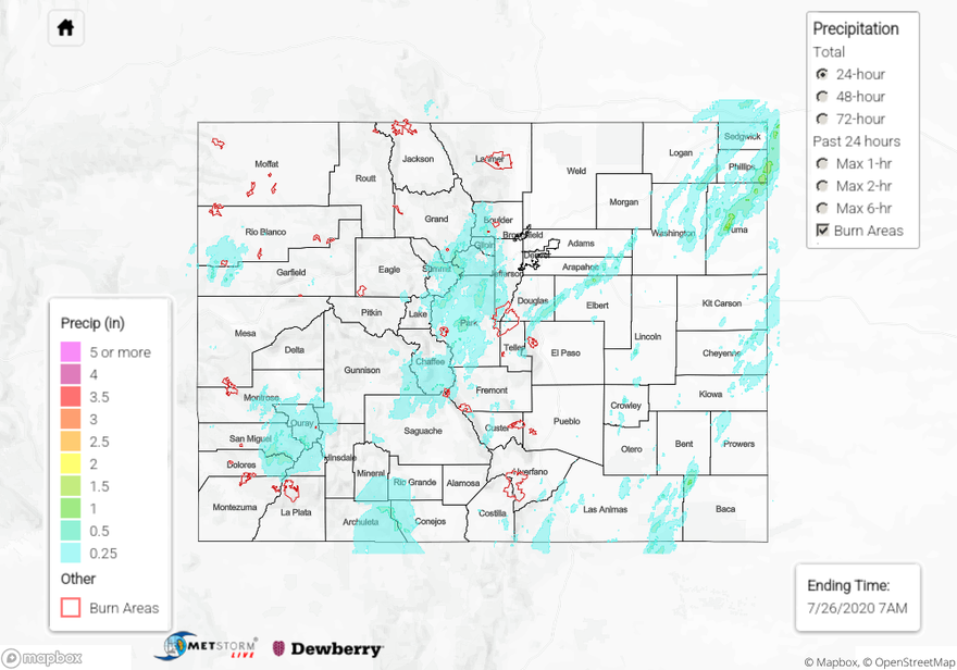
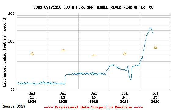
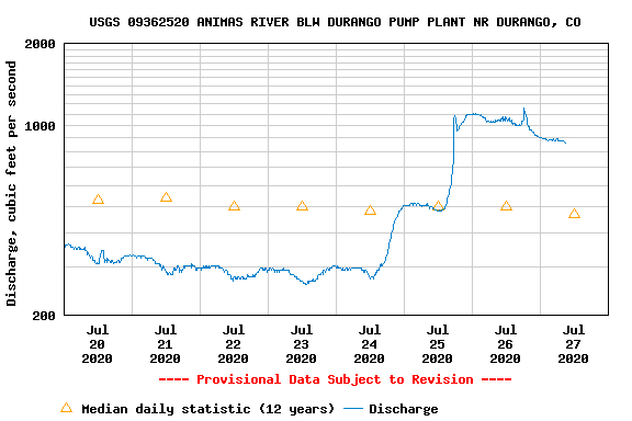
Since we are going on several days with significant rainfall over the state, check out the 72-hour precipitation accumulation over the state in the QPE map below. Many locations in the San Juan Mountains, Southeast Mountains, eastern Central Mountains, southern Front Range, and the Northeast/Southeast Plains have picked up between 1.5” and 2.5” of rain over this 72-hour period. A CoCoRaHS observer 17 miles ENE of Dolores has recorded about 3 inches of precipitation since Friday! This is causing soils to stay saturated and allowing streams and rivers to rise due to runoff from this rainfall. Below is an example of this increased runoff causing the Animas River in Durango, CO to flow well above the 12-year daily median, peaking at over 1100 cfs compared to a daily median of 500 cfs. Up to this point, major rivers have stayed below flood stage due to low flows before this event, but we are watching local streams and creeks closely. For example, Mineral Creek stranded hikers on Saturday, and the Navajo River near Chromo was about 0.3 feet shy of it’s 5.1 feet record. With more rainfall coming to the San Juans today, please use caution near fast moving water and follow the daily Flood Threat Bulletin for the latest.

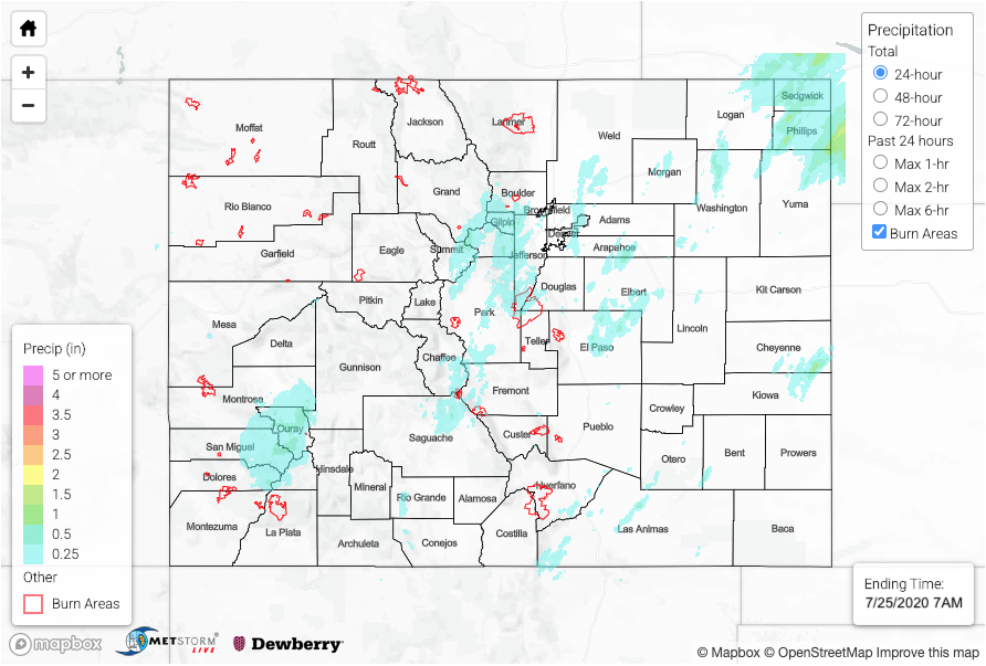
To see how much monsoon rainfall has fallen in your area over the last 24, 48, and 72 hours, check out our State Precipitation Map below.

Click Here For Map Overview

The map below shows radar-estimated, rainfall gage-adjusted Quantitative Precipitation Estimates (QPE) across Colorado. The map is updated daily during the operational season (May 1 – Sep 30) by 11AM. The following six layers are currently available: 24-hour, 48-hour and 72-hour total precipitation, as well as maximum 1-hour, 2-hour and 6-hour precipitation over the past 24 hour period (to estimate where flash flooding may have occurred). The 24-hour, 48-hour and 72-hour total precipitation contain bias corrections that are not disaggregated into the hourly estimates, so there will likely be some differences. The accumulation ending time is 7AM of the date shown in the bottom right corner. Also shown optionally are vulnerable fire burn areas (post 2012), which are updated throughout the season to include new, vulnerable burn areas. The home button in the top left corner resets the map to the original zoom.

SPM 07-26-2020: Heavy Rain, Sponsored by Monsoon, Continued on Saturday

Issue Date: Sunday, July 26th, 2020
Issue Time: 10:45AM MDT

Summary:

Multiple rounds of heavy rainfall occurred during the afternoon and evening hours mainly across Colorado’s higher terrain on Saturday. From a climatological perspective, we are approaching the peak of the monsoon season, so this rainfall occurred right “on time”. The highest rainfall amounts occurred over the western part of the San Juan Mountains. Widespread amounts over 1 inch fell across Ouray, San Miguel, Dolores, San Juan, Montezuma and La Plata counties. Observations in the higher terrain of this area are quite sparse, but it is likely that intensities of 0.5 inches in 30 minutes or so were common. One report near Durango showed over 1 inch of rain fell in less than 30 minutes. Many areas received multiple rounds of heavy rainfall, which combined with the antecedent wet soils to produce more efficient runoff. The NWS issued four Flood Advisories in the afternoon and evening over the higher terrain of the San Juans. The Durango Herald reported that several hikers in Silverton had to be rescued due to high water and County Road 7 was closed beyond Ice Lake. The hydrograph from Mineral Creek in Silver, below, shows quite a sharp increase in flow yesterday afternoon, and even higher spikes were likely in the upstream areas. The Dolores River also showed a marked increase in flow, but has thus far stayed below flood stage.

Elsewhere, isolated heavy rainfall occurred over the Central Mountains and farther east as well, with a few locations receiving over 1 inch that likely came from multiple rounds of heavy rainfall.

To view the latest hydrologic conditions across Colorado, check out the DWR site below:
https://dwr.state.co.us/tools/stations

To see precipitation estimates over your area the last 24 to 72-hours, scroll down to the State Precipitation Map below.

Click Here For Map Overview

The map below shows radar-estimated, rainfall gage-adjusted Quantitative Precipitation Estimates (QPE) across Colorado. The map is updated daily during the operational season (May 1 – Sep 30) by 11AM. The following six layers are currently available: 24-hour, 48-hour and 72-hour total precipitation, as well as maximum 1-hour, 2-hour and 6-hour precipitation over the past 24 hour period (to estimate where flash flooding may have occurred). The 24-hour, 48-hour and 72-hour total precipitation contain bias corrections that are not disaggregated into the hourly estimates, so there will likely be some differences. The accumulation ending time is 7AM of the date shown in the bottom right corner. Also shown optionally are vulnerable fire burn areas (post 2012), which are updated throughout the season to include new, vulnerable burn areas. The home button in the top left corner resets the map to the original zoom.

SPM 07-25-2020: Heavy Rainfall Event Begins over the San Juan Mountains

Issue Date: Saturday, July 25th, 2020
Issue Time: 10:45AM MDT

Summary:

With the moisture plume in place, there was another round of rainfall oriented from southwest to northeast again. A little better moisture was in place, but over the mountains, limited instability allowed rain rates to stay low enough that there was little flooding reported. The highest totals over the Front Range were just under 0.75 inches. We’ve been keeping our eye on the the San Juan Mountains, as a multi-day rainfall event begins. The western portions picked up widespread totals of 0.75 inches to more isolate 1.50 inches on south facing slopes. An areal flood advisory was issued just before 6PM for the Uncompahgre Wilderness Area due to rock slides being reported onto roadways. Observations in the area ranged from about 0.80 inches to up to 2 inches! With more rain coming today and tonight, there’s an increased risk for mud flows and rapid rises in local streams/creeks. Streams in the area were already showing high flows (see the South Fork San Miguel River near Ophir below), which means some soils could already be saturated before today’s rainfall even begins (runoff). Please continue to follow the FTB for the latest and send any storm reports to us here: https://archive-coftb.dewberryanalytics.com/?page_id=11165

Training storms again produced high totals over the Northeast Plains, thankfully not directly over Wray AND slightly lower totals for Colorado. The heaviest rainfall from the storms was just over the border in Nebraska where about 4.5 inches of rain fell in the core (not shown below). A CoCoRaHS station in Phillips County observed 1.01 inches. Flooding was not reported on Friday.

To see precipitation estimates over your area the last 24 to 72-hours, scroll down to the State Precipitation Map below.

Click Here For Map Overview

The map below shows radar-estimated, rainfall gage-adjusted Quantitative Precipitation Estimates (QPE) across Colorado. The map is updated daily during the operational season (May 1 – Sep 30) by 11AM. The following six layers are currently available: 24-hour, 48-hour and 72-hour total precipitation, as well as maximum 1-hour, 2-hour and 6-hour precipitation over the past 24 hour period (to estimate where flash flooding may have occurred). The 24-hour, 48-hour and 72-hour total precipitation contain bias corrections that are not disaggregated into the hourly estimates, so there will likely be some differences. The accumulation ending time is 7AM of the date shown in the bottom right corner. Also shown optionally are vulnerable fire burn areas (post 2012), which are updated throughout the season to include new, vulnerable burn areas. The home button in the top left corner resets the map to the original zoom.

SPM 07-24-2020: Heavy, Heavy Rainfall Over Yuma County with Flash Flooding

Issue Date: Friday, July 24th, 2020
Issue Time: 11:00AM MDT

Summary:

The monsoon moisture plume stayed overhead yesterday, but with less mid-level energy moving through the flow, rainfall was not as widespread or convective as Wednesday. Storms began to develop over the mountains by early afternoon with the diurnal flow pattern. Over western Colorado, storms to the north generally produced totals under 0.25 inches with the higher elevations of eastern Garfield County reaching up to a quarter of an inch. CoCoRaHS stations in and around Steamboat Springs picked up between 0.17 and 0.37 inches for the day. Storm outflow also produced 50 mph wind gusts over the Southwest Slope.

A second plume of moisture and energy arrived to the San Juan Mountains by about 10PM, which brought morning rainfall to the Central and Northern Mountains (today). Totals over the highest peaks were around 0.50 inches with isolated totals up to 0.75 inches. In Durango, there was a heavy rain report of 0.67 inches. The 416 burn area received between 0.25 and 0.45 inches, which is important to keep track of with the upcoming event (antecedent soil moisture). Thankfully, rainfall was gradual enough that flooding issues were avoided.

In the late afternoon and evening hours, convergence along the eastern side of the lee cyclone helped pop the cap for some thunderstorms over the eastern plains. While coverage was spotty, these storms produced a lot of rainfall with dew points in the low 60Fs. QPE estimates a small rain core of 2 inches in Prowers. Nearby observations were close to an inch, so this might be a little high, but not by much. The real story was a training storm over Yuma. Wray was hit with rain totals (likely) up to 5.14 inches between ~8PM and 1AM! That’s between a 100 and 200-year event over a 6-hour span. A CoCoRaHS station southeast of town had 3.91 inches, which is close to a 1 in 50-year event. The airport picked up 3.41 inches. Not surprisingly, this producing standing water on 385 and closed US 34. Just over the border, rainfall reports ranged from 3.8 inches up to 9.5 inches!!! There were two reports in Dundy County greater than 9 inches.

For rainfall estimates in your neighborhood over the last 24-hours, check out our State Precipitation Map below.

Click Here For Map Overview

The map below shows radar-estimated, rainfall gage-adjusted Quantitative Precipitation Estimates (QPE) across Colorado. The map is updated daily during the operational season (May 1 – Sep 30) by 11AM. The following six layers are currently available: 24-hour, 48-hour and 72-hour total precipitation, as well as maximum 1-hour, 2-hour and 6-hour precipitation over the past 24 hour period (to estimate where flash flooding may have occurred). The 24-hour, 48-hour and 72-hour total precipitation contain bias corrections that are not disaggregated into the hourly estimates, so there will likely be some differences. The accumulation ending time is 7AM of the date shown in the bottom right corner. Also shown optionally are vulnerable fire burn areas (post 2012), which are updated throughout the season to include new, vulnerable burn areas. The home button in the top left corner resets the map to the original zoom.