Issue Date: Friday, July 24th, 2020
Issue Time: 11:00AM MDT
Summary:
The monsoon moisture plume stayed overhead yesterday, but with less mid-level energy moving through the flow, rainfall was not as widespread or convective as Wednesday. Storms began to develop over the mountains by early afternoon with the diurnal flow pattern. Over western Colorado, storms to the north generally produced totals under 0.25 inches with the higher elevations of eastern Garfield County reaching up to a quarter of an inch. CoCoRaHS stations in and around Steamboat Springs picked up between 0.17 and 0.37 inches for the day. Storm outflow also produced 50 mph wind gusts over the Southwest Slope.
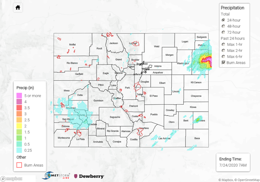
A second plume of moisture and energy arrived to the San Juan Mountains by about 10PM, which brought morning rainfall to the Central and Northern Mountains (today). Totals over the highest peaks were around 0.50 inches with isolated totals up to 0.75 inches. In Durango, there was a heavy rain report of 0.67 inches. The 416 burn area received between 0.25 and 0.45 inches, which is important to keep track of with the upcoming event (antecedent soil moisture). Thankfully, rainfall was gradual enough that flooding issues were avoided.
In the late afternoon and evening hours, convergence along the eastern side of the lee cyclone helped pop the cap for some thunderstorms over the eastern plains. While coverage was spotty, these storms produced a lot of rainfall with dew points in the low 60Fs. QPE estimates a small rain core of 2 inches in Prowers. Nearby observations were close to an inch, so this might be a little high, but not by much. The real story was a training storm over Yuma. Wray was hit with rain totals (likely) up to 5.14 inches between ~8PM and 1AM! That’s between a 100 and 200-year event over a 6-hour span. A CoCoRaHS station southeast of town had 3.91 inches, which is close to a 1 in 50-year event. The airport picked up 3.41 inches. Not surprisingly, this producing standing water on 385 and closed US 34. Just over the border, rainfall reports ranged from 3.8 inches up to 9.5 inches!!! There were two reports in Dundy County greater than 9 inches.
For rainfall estimates in your neighborhood over the last 24-hours, check out our State Precipitation Map below.
Click Here For Map Overview