Issue Date: Monday, July 27th, 2020
Issue Time: 10:55AM MDT
Summary:
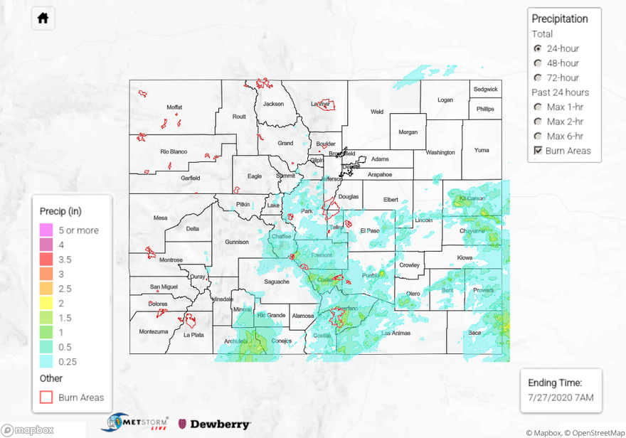
Heavy rain fell over the southern half of Colorado, which brought significant 24-hour rain totals for the southern San Juan Mountains, Southeast Mountains, and portions of the Palmer Ridge and Southeast/Northeast Plains. Today’s QPE map shows 24-hour rain totals reached up to 2 inches over the southern San Juan Mountains. The highest rain gauge report in this area was 1.76 inch from a CoCoRaHS observer over southeastern Archuleta County. Several other rain gauges in the area southeast of the town of Pagosa Springs picked up around 1.4 inch. No flooding was reported in the area, but a CoCoRaHS observer near Pagosa Springs mentioned that drainages were full.
Storms were able to fire over the Southeast Mountains by noon yesterday, which lingered over the area well into the overnight hours (ending ~ 3AM MDT). Some of these storms caused flash flooding near the Decker and Spring Creek burn areas. Storms over the Decker burn area produced up to 2 inches of rain over a couple hours according to an ASOS station near the burn area. This heavy rain caused a county road to be washed out by flash flooding of the Bear Creek just south of Salida, CO, and caused flooding in a home. Storms over the Spring Creek burn area dropped up to 1.79 inch of rain, indicated by a USGS rain gauge along the southwestern portion of Huerfano County. QPE generally agrees with observations in the area and shows 1+ inch of rain fell over eastern portions of the Spring Creek burn area. A flash flood was reported along Colorado highway 12 in southwestern Huerfano County. Many other locations along and just east of the Southeast Mountains saw heavy rain yesterday, with numerous 24-hour rain reports over 1 inch in Huerfano and Custer counties. Take a look at today’s QPE map below.
The plains of eastern Colorado did not miss out on heavy rain yesterday. The strongest storms were able to develop over Kit Carson and Cheyenne counties, where a couple severe thunderstorm warnings were issued. The highest 24-hour rain total was 2.21 inches from a CoCoRaHS station in far eastern Cheyenne County. A couple of ASOS stations in central Kit Carson County also picked up just over 2 inches of rain from storms in the area. The QPE map appears to agree with these maxima in rain accumulations just over 2 inches, and it shows the isolated nature of these higher rain totals. These severe storms also dropped up to dime size hail. Even though heavy rain was reported by many stations in this area, no flooding was reported.
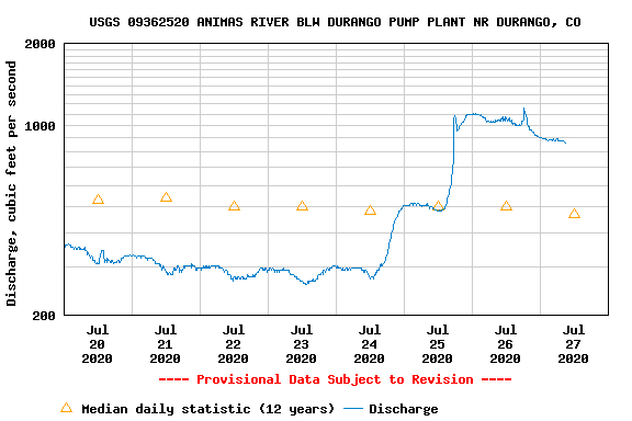
Since we are going on several days with significant rainfall over the state, check out the 72-hour precipitation accumulation over the state in the QPE map below. Many locations in the San Juan Mountains, Southeast Mountains, eastern Central Mountains, southern Front Range, and the Northeast/Southeast Plains have picked up between 1.5” and 2.5” of rain over this 72-hour period. A CoCoRaHS observer 17 miles ENE of Dolores has recorded about 3 inches of precipitation since Friday! This is causing soils to stay saturated and allowing streams and rivers to rise due to runoff from this rainfall. Below is an example of this increased runoff causing the Animas River in Durango, CO to flow well above the 12-year daily median, peaking at over 1100 cfs compared to a daily median of 500 cfs. Up to this point, major rivers have stayed below flood stage due to low flows before this event, but we are watching local streams and creeks closely. For example, Mineral Creek stranded hikers on Saturday, and the Navajo River near Chromo was about 0.3 feet shy of it’s 5.1 feet record. With more rainfall coming to the San Juans today, please use caution near fast moving water and follow the daily Flood Threat Bulletin for the latest.
To see how much monsoon rainfall has fallen in your area over the last 24, 48, and 72 hours, check out our State Precipitation Map below.

