SPM 09-05-2020: Beautiful Day with Isolated Storms Over the Southern Mountains

Issue Date: Saturday, September 5th, 2020
Issue Time: 8:55AM MDT

Summary:

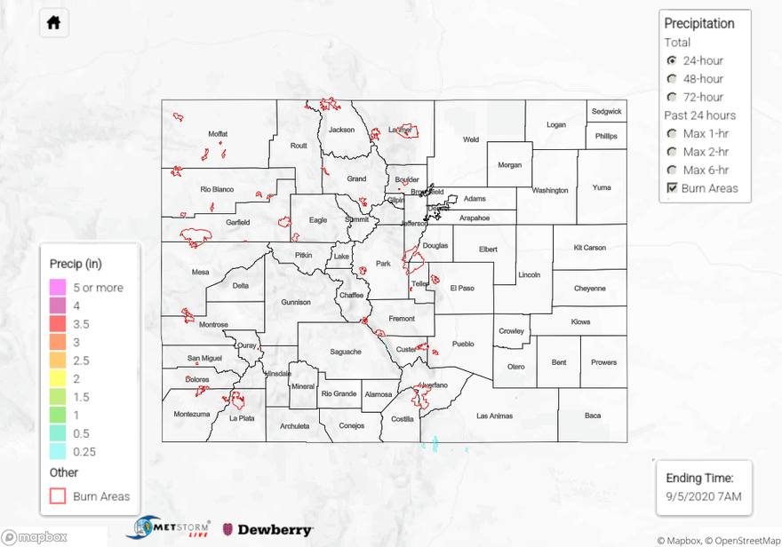
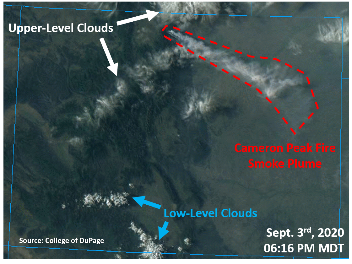
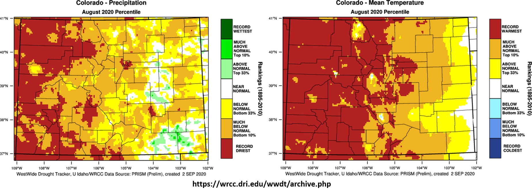
Temperatures started rebounding quickly yesterday after a couple days of cooler weather. Highs reach the 90Fs over the plains and western valleys, 90Fs along the urban corridor and 80Fs in most of the lower elevation mountain towns. Fair weather cumulus formed over the southern mountains yesterday afternoon with a couple showers over the Southeast Mountains. Totals were mostly trace amounts to 0.10 inches with slightly higher totals (up to 0.25 inches) over the Raton Ridge/Southeast Mountain intersect on the southern border indicated by radar. Near surface smoke continued to be an issue for the Cameron Peak fire. Hopefully there won’t be too much growth tomorrow afternoon with a Red Flag Warning in place for most of northern Colorado (including the plains).

Ongoing large fire update (as of 8:45AM on InciWeb):
Cameron Peak Fire in the Medicine Bow Mountains: 23,903 acres; 6% contained
Williams Fork Fire  in the Arapaho National Forest: 12,125 acres; 10% contained
Pine Gulch Fire north of Grand Junction: 139,007 acres; 87% contained
Grizzly Creek Fire  in Glenwood Canyon: 32,464 acres; 83% contained

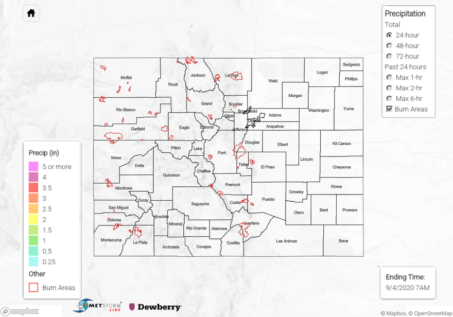
To see precipitation estimates over your neighborhood the last 24-hours, scroll down to the State Precipitation Map below.

Click Here For Map Overview

The map below shows radar-estimated, rainfall gage-adjusted Quantitative Precipitation Estimates (QPE) across Colorado. The map is updated daily during the operational season (May 1 – Sep 30) by 11AM. The following six layers are currently available: 24-hour, 48-hour and 72-hour total precipitation, as well as maximum 1-hour, 2-hour and 6-hour precipitation over the past 24 hour period (to estimate where flash flooding may have occurred). The 24-hour, 48-hour and 72-hour total precipitation contain bias corrections that are not disaggregated into the hourly estimates, so there will likely be some differences. The accumulation ending time is 7AM of the date shown in the bottom right corner. Also shown optionally are vulnerable fire burn areas (post 2012), which are updated throughout the season to include new, vulnerable burn areas. The home button in the top left corner resets the map to the original zoom.

SPM 09-04-2020: Cameron Peak Fire Smoke Plume Visible Once Again

Issue Date: Friday, September 4th, 2020
Issue Time: 10:00AM MDT

Summary:

The true-color satellite image below shows it was mainly sunny yesterday afternoon across Colorado. A few upper-level cirrus clouds moved over northern/eastern Colorado, traveling through the northwest flow, but no precipitation was associated with them. A few fair weather cumulus clouds formed over the southern San Juan Mountains yesterday afternoon, but these were not rain producers either. No precipitation was measured across the state yesterday.

The most interesting feature from yesterday is the return of the smoke plume from the Cameron Peak wildfire, which stretched from its source in Larimer County southeast into the plains of Eastern Colorado. This indicates some active fire behavior yesterday. This morning’s updated fire information agrees with this, showing an 866 acre increase in size yesterday and no increase in containment (see below). Continued fire activity and increased smoke is expected today (see the FTB) as well as tomorrow. This includes the William’s Peak fire expanding this weekend with the hot and dry conditions. Fortunately, the Pine Gulch and Grizzly Creek wildfires have some significant containment, so mainly just internal flare-ups are likely for these two fires.

Colorado large wildfire updates (as of 9:15AM on InciWeb):
Pine Gulch – north of Grand Junction: 139,007 acres; 87% contained (6% increased containment)
Grizzly Creek – Glenwood Canyon: 32,464 acres; 83% contained (1% increased containment)
Cameron Peak – Medicine Bow Mountains: 23,903 acres; 6% contained (increased size by 866 acres)
Williams Fork – Arapaho National Forecast: 12,099 acres; 10% contained

Rain accumulation over the last 24 to 72-hours can be visualized on our State Precipitation Map below.

Click Here For Map Overview

The map below shows radar-estimated, rainfall gage-adjusted Quantitative Precipitation Estimates (QPE) across Colorado. The map is updated daily during the operational season (May 1 – Sep 30) by 11AM. The following six layers are currently available: 24-hour, 48-hour and 72-hour total precipitation, as well as maximum 1-hour, 2-hour and 6-hour precipitation over the past 24 hour period (to estimate where flash flooding may have occurred). The 24-hour, 48-hour and 72-hour total precipitation contain bias corrections that are not disaggregated into the hourly estimates, so there will likely be some differences. The accumulation ending time is 7AM of the date shown in the bottom right corner. Also shown optionally are vulnerable fire burn areas (post 2012), which are updated throughout the season to include new, vulnerable burn areas. The home button in the top left corner resets the map to the original zoom.

SPM 09-03-2020: Warm, Dry, and Sunny

Issue Date: Thursday, September 3rd, 2020
Issue Time: 10:05AM MDT

Summary:

Not much in terms of interesting weather happened in Colorado yesterday as even clouds were hard to find. Temperatures were slightly above average, with Denver adding to its tally of 90 degree days this year with a high of 92F. Grand Junction reached 89F, a few degrees above average, but woke up to some below average morning low temperatures of 50F. The large diurnal swing in temperature was possible due to the much drier air over Colorado yesterday, with relative humidity dropping to 10-20% for many locations across the state. Some gusty afternoon winds up to 30 mph were also present over the Northern Mountains and Front Range. Luckily, these winds did not cause significant issues for the current wildfires (see update below).

Today’s newly released US Drought Monitor maps (see image below) show that Colorado is still dealing with moderate (98.8% of area) to exceptional drought (0.4% of area) as of September 1st, 2020. A small area of drought improvement occurred along the southern Front Range and northern Southeast Mountains regions (see right panel of image below), but this area is still experiencing moderate drought conditions. Rain gauges in this area indicate up to 1.5 inches of rain fell over the week (25 Aug. through 1 Sept.). Unfortunately, the dry weather this week and over the weekend will likely allow the drought conditions to remain.

Colorado large wildfire updates (as of 9:00AM on InciWeb):
Pine Gulch – north of Grand Junction: 139,007 acres; 81% contained
Grizzly Creek – Glenwood Canyon: 32,464 acres; 82% contained (increased containment)
Cameron Peak – Medicine Bow Mountains: 23,037 acres; 6% contained (small increase in size & containment)
Williams Fork – Arapaho National Forecast: 12,097 acres; 10% contained

To see rainfall estimates back to 72 hours, check out our State Precipitation Map below.

Click Here For Map Overview

The map below shows radar-estimated, rainfall gage-adjusted Quantitative Precipitation Estimates (QPE) across Colorado. The map is updated daily during the operational season (May 1 – Sep 30) by 11AM. The following six layers are currently available: 24-hour, 48-hour and 72-hour total precipitation, as well as maximum 1-hour, 2-hour and 6-hour precipitation over the past 24 hour period (to estimate where flash flooding may have occurred). The 24-hour, 48-hour and 72-hour total precipitation contain bias corrections that are not disaggregated into the hourly estimates, so there will likely be some differences. The accumulation ending time is 7AM of the date shown in the bottom right corner. Also shown optionally are vulnerable fire burn areas (post 2012), which are updated throughout the season to include new, vulnerable burn areas. The home button in the top left corner resets the map to the original zoom.

SPM 09-02-2020: Mostly Dry and Mild

Issue Date: Wednesday, September 2nd, 2020
Issue Time: 09:40AM MDT

Summary:

Yesterday remained dry for most locations across Colorado, with only a couple morning showers and weak afternoon convective cells over the southern mountains. The morning showers produced up to 0.16 inches of rain near the Great Sand Dunes National Park according to rain gauges. The weak afternoon convection fired over remote western Las Animas County, along the border between the Southeast Mountains and Raton Ridge, but QPE only indicates up to 0.25 inches of rain fell. Stronger convection remained south of the Colorado border in New Mexico. No flooding was reported in Colorado yesterday.

Temperatures across the state yesterday were well below climatological average. Denver only got up to 80F (4F below normal), and Grand Junction only got up to 78F (8F below normal). Leadville, at 10,152 ft above sea level, barely got out of the 50Fs for a high. These cooler temperatures are a welcome relief to the record August heat we’ve been experiencing.

Taking a look back at the full month of August, most of Colorado experienced below normal to record driest precipitation (left panel on image below). The western slope experienced the driest conditions with most of the area in record driest territory. Isolated locations along the plains of eastern Colorado were actually able to get above normal precipitation for the month. This is due to some of the strong thunderstorms that dropped heavy rain over the plains during the first week and the last few days of the month, which was able to tap into more moisture from the east. However, with the record heat of August 2020 (right panel on image below), severe drought conditions were able to expand drastically across the state, as pointed out in the FTO last Thursday. This also made the 2020 wildfire season one of the more active in recent years, with the largest Colorado wildfire now in the record books (Pine Gulch Fire). Note that increased moisture along the eastern Colorado border likely allowed these locations to remain near normal in terms of temperature. The absence of a strong monsoon kept moisture low and temperatures high in western Colorado. Grand Junction only received 0.07 inches of rain over two days at the end of August, which is 7% of their normal 0.95 inch monthly total.

Colorado large wildfire updates (as of 9:00AM on InciWeb):
Pine Gulch – north of Grand Junction: 139,007 acres; 81% contained
Grizzly Creek – Glenwood Canyon: 32,464 acres; 75% contained
Cameron Peak – Medicine Bow Mountains: 23,022 acres; 5% contained
Williams Fork – Arapaho National Forecast: 12,097 acres; 10% contained

For rainfall estimates in your area over the last 24 to 72 hours, check out our State Precipitation Map below.

Click Here For Map Overview

The map below shows radar-estimated, rainfall gage-adjusted Quantitative Precipitation Estimates (QPE) across Colorado. The map is updated daily during the operational season (May 1 – Sep 30) by 11AM. The following six layers are currently available: 24-hour, 48-hour and 72-hour total precipitation, as well as maximum 1-hour, 2-hour and 6-hour precipitation over the past 24 hour period (to estimate where flash flooding may have occurred). The 24-hour, 48-hour and 72-hour total precipitation contain bias corrections that are not disaggregated into the hourly estimates, so there will likely be some differences. The accumulation ending time is 7AM of the date shown in the bottom right corner. Also shown optionally are vulnerable fire burn areas (post 2012), which are updated throughout the season to include new, vulnerable burn areas. The home button in the top left corner resets the map to the original zoom.