SPM 05-15-2021: Severe Thunderstorms on Eastern Plains

Issue Date: Saturday, May 15, 2021
Issue Time: 9:30 am MDT

Summary

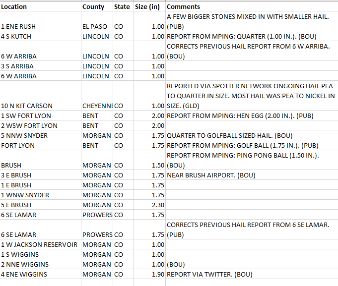
The convective outlook from the SPC yesterday indicated that most of the state had the potential for thunderstorms, with marginal to slight risk of convective activity along the Eastern Plains, especially the northeast corner. During the late morning-early afternoon yesterday, isolated storms began to materialize over high elevations and made their way eastward. The main story as these storms picked up energy on their way east was the large, damaging hail reported across the eastern half of the state. From Brush to Lamar, hail reports over 1” were reported, including a 2.30 inch report in Brush. A complete list of severe hail reports yesterday is found in the table below.

Flooding was not reported on Saturday. For rainfall estimates in your area, check out our State Precipitation Map below. It is important to consider the potential for hail contamination in rainfall estimates, especially those remotely sensed (like radar) or when hail stones melt in rain gages and artificially inflate the precipitation totals. For example, a 0.88 precipitation observation was made by a CoCoRaHS observer in Briggsdale yesterday, but the observer also made note of hail in the observation. Different products account for hail contamination in different ways, which is potentially why the 0.88 inches is not seen in the MetStorm live gridded QPE.

Click Here For Map Overview

The map below shows radar-estimated, rainfall gage-adjusted Quantitative Precipitation Estimates (QPE) across Colorado. The map is updated daily during the operational season (May 1 – Sep 30) by 11AM. The following six layers are currently available: 24-hour, 48-hour and 72-hour total precipitation, as well as maximum 1-hour, 2-hour and 6-hour precipitation over the past 24 hour period (to estimate where flash flooding may have occurred). The accumulation ending time is 7AM of the date shown in the bottom right corner. Also shown optionally are vulnerable fire burn areas (post 2012), which are updated throughout the season to include new, vulnerable burn areas. The home button in the top left corner resets the map to the original zoom.
SPM 05-14-2021: Warm and Dry Spring Day

Issue Date: Friday, May 14, 2021
Issue Time: 9:00 am MDT

Summary

May 13 was another calm and clear day across the state, as a weak high-pressure ridge in the southwest corner of the state dominated the weather pattern. As such, there was only trace to very light (0.1-0.2”) precipitation recorded at the various CoCoRaHS, SNOTEL, and MesoWest gauges scattered across the state. Flooding was not reported on Thursday. For rainfall estimates in your area, check out our State Precipitation Map below.

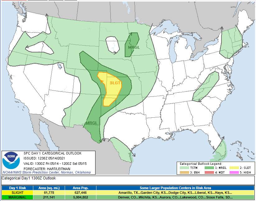
There was potential for isolated but severe thunderstorms on the Northeastern plains yesterday, and while nothing serious materialized in Colorado, just across the border in Kansas, a landspout tornado was reported along I-70. Nearly all of the state has the potential for thunderstorms today according the SPC map below. The area of marginal risk for convective activity today includes Denver and the northern Front Range, and slight (higher than marginal) risk is extended to the Northeast Plains.

Click Here For Map Overview

The map below shows radar-estimated, rainfall gage-adjusted Quantitative Precipitation Estimates (QPE) across Colorado. The map is updated daily during the operational season (May 1 – Sep 30) by 11AM. The following six layers are currently available: 24-hour, 48-hour and 72-hour total precipitation, as well as maximum 1-hour, 2-hour and 6-hour precipitation over the past 24 hour period (to estimate where flash flooding may have occurred). The accumulation ending time is 7AM of the date shown in the bottom right corner. Also shown optionally are vulnerable fire burn areas (post 2012), which are updated throughout the season to include new, vulnerable burn areas. The home button in the top left corner resets the map to the original zoom.
SPM 05-13-2021: Thursday Drought Monitor Update

Issue Date: Thursday, May 13, 2021
Issue Time: 9:15 am MDT

Summary

Yesterday was fairly uneventful in terms of precipitation across the state. A line of thunderstorms extending into the Northeast Plains from the Nebraska border dropped a quick 0.1-0.4 inches of rain yesterday afternoon. Additionally, a handful of high-elevation SNOTEL stations had light accumulations too. Flooding was not reported on Wednesday. For rainfall estimates in your area, check out our State Precipitation Map below.

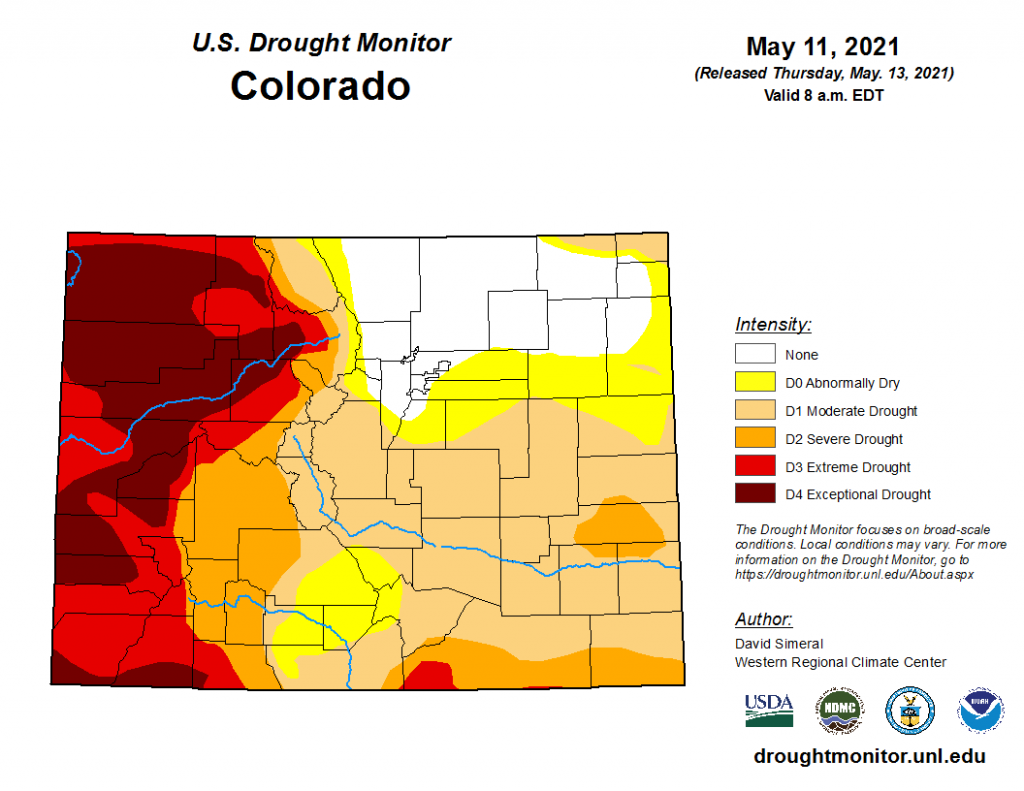
Updates to the U.S. Drought Monitor were published today, with great news for Northeast Colorado as the area of “None” drought conditions expanded following the latest soaking rain at the start of the week. On the flip side, the southern and western halves of the state are still experiencing moderate to exceptional drought, with the worst of it following along the Northwest and Southwest Slopes, as well as into the Grand Valley. Unfortunately, there doesn’t look to be much help coming in the forecast either aside from isolated thunderstorms, which have the potential to be more harmful than helpful as gusty outflow winds can contribute to elevated fire danger.

Click Here For Map Overview

The map below shows radar-estimated, rainfall gage-adjusted Quantitative Precipitation Estimates (QPE) across Colorado. The map is updated daily during the operational season (May 1 – Sep 30) by 11AM. The following six layers are currently available: 24-hour, 48-hour and 72-hour total precipitation, as well as maximum 1-hour, 2-hour and 6-hour precipitation over the past 24 hour period (to estimate where flash flooding may have occurred). The accumulation ending time is 7AM of the date shown in the bottom right corner. Also shown optionally are vulnerable fire burn areas (post 2012), which are updated throughout the season to include new, vulnerable burn areas. The home button in the top left corner resets the map to the original zoom.

SPM 05-12-2021: Diminishing Snow and Rain

Issue Date: Wednesday, May 12, 2021
Issue Time: 9:40 am MDT

Summary

Yesterday saw diminishing precipitation associated with the low-pressure system that brought heavy mountain snow and widespread precipitation across the eastern half of the state. Still, mountain SNOTEL stations picked up an additional 3-7 inches of snow in 24-hours, bringing some total snow depths with this storm to over 14 inches in Boulder and Larimer Counties. Accumulated liquid precipitation for the past few days shows the Front Range and Eastern Plains picked up significant amounts of moisture – up to 2.25 inches. Flooding was not reported on Monday. For rainfall estimates in your area, check out our State Precipitation Map below.

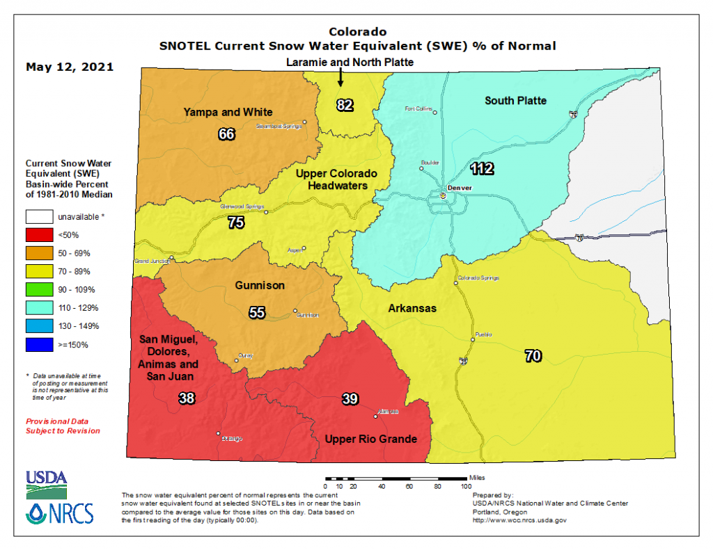
This added moisture helped boost the South Platte Basin’s current snowpack (as snow water equivalent) to 112% of normal! Unfortunately, the good news does not extend to the rest of the state, with remaining basins well below normal snowpack. The San Miguel-Dolores-Animas-San Juan and Upper Rio Grande Basins saw almost no accumulated precipitation associated with this spring storm, and are now below 50% of normal snowpack, according the NRCS map below.

Click Here For Map Overview

The map below shows radar-estimated, rainfall gage-adjusted Quantitative Precipitation Estimates (QPE) across Colorado. The map is updated daily during the operational season (May 1 – Sep 30) by 11AM. The following six layers are currently available: 24-hour, 48-hour and 72-hour total precipitation, as well as maximum 1-hour, 2-hour and 6-hour precipitation over the past 24 hour period (to estimate where flash flooding may have occurred). The accumulation ending time is 7AM of the date shown in the bottom right corner. Also shown optionally are vulnerable fire burn areas (post 2012), which are updated throughout the season to include new, vulnerable burn areas. The home button in the top left corner resets the map to the original zoom.