Issue Date: Saturday, May 15, 2021
Issue Time: 9:30 am MDT
Summary
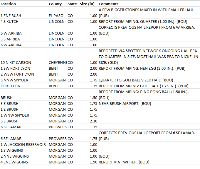
The convective outlook from the SPC yesterday indicated that most of the state had the potential for thunderstorms, with marginal to slight risk of convective activity along the Eastern Plains, especially the northeast corner. During the late morning-early afternoon yesterday, isolated storms began to materialize over high elevations and made their way eastward. The main story as these storms picked up energy on their way east was the large, damaging hail reported across the eastern half of the state. From Brush to Lamar, hail reports over 1” were reported, including a 2.30 inch report in Brush. A complete list of severe hail reports yesterday is found in the table below.
Flooding was not reported on Saturday. For rainfall estimates in your area, check out our State Precipitation Map below. It is important to consider the potential for hail contamination in rainfall estimates, especially those remotely sensed (like radar) or when hail stones melt in rain gages and artificially inflate the precipitation totals. For example, a 0.88 precipitation observation was made by a CoCoRaHS observer in Briggsdale yesterday, but the observer also made note of hail in the observation. Different products account for hail contamination in different ways, which is potentially why the 0.88 inches is not seen in the MetStorm live gridded QPE.
Click Here For Map Overview
The map below shows radar-estimated, rainfall gage-adjusted Quantitative Precipitation Estimates (QPE) across Colorado. The map is updated daily during the operational season (May 1 – Sep 30) by 11AM. The following six layers are currently available: 24-hour, 48-hour and 72-hour total precipitation, as well as maximum 1-hour, 2-hour and 6-hour precipitation over the past 24 hour period (to estimate where flash flooding may have occurred). The accumulation ending time is 7AM of the date shown in the bottom right corner. Also shown optionally are vulnerable fire burn areas (post 2012), which are updated throughout the season to include new, vulnerable burn areas. The home button in the top left corner resets the map to the original zoom.

