SPM 05-19-2021: Another Round of Heavy Rain for Southeast Colorado

Issue Date: Wednesday, May 19, 2021
Issue Time: 9:00 am MDT

Summary

A low-pressure system on the Colorado-New Mexico border spun up moisture into the Southeastern portion of the state yesterday, which produced heavy rain and even snow at high elevations west of Pueblo. Minor flooding reports were made along roads in Beulah, CO again as Squirrel Creek is running high. Further east, one CoCoRaHS observer in La Junta (CO-OT-42) took detailed notes describing the nature of the 1.46 inches recorded at their station yesterday:

“Rain and hail started at 2:45 pm. Pea size hail from the start of the storm. Hail and very heavy rain lasted for about 25 minutes. ground covered with about 2 inches of hail. rain continued for another hour. lots of lightning and wind. trees lost some leaves, garden plants badly damaged. water falls running off the top of the mesa. arroyos running. wonderful moisture!!”

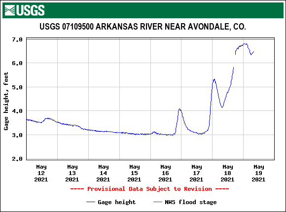
In additional to the heavy rain, minor flooding was reported at this CoCoRaHS station. Similarly, nearly every USGS gauge on the Arkansas River is at or exceeding 95th percentile streamflow for this time of year, and the Arkansas River near Avondale reached just below flood stage this morning, as seen in the plot below.
As for the rest of the state, thunderstorms brought moderate rain to the Front Range and Northeastern Plains. Some much-needed rain also fell in Southwestern Colorado. For rainfall estimates in your area, check out our State Precipitation Map below.

Click Here For Map Overview

The map below shows radar-estimated, rainfall gage-adjusted Quantitative Precipitation Estimates (QPE) across Colorado. The map is updated daily during the operational season (May 1 – Sep 30) by 11AM. The following six layers are currently available: 24-hour, 48-hour and 72-hour total precipitation, as well as maximum 1-hour, 2-hour and 6-hour precipitation over the past 24 hour period (to estimate where flash flooding may have occurred). The accumulation ending time is 7AM of the date shown in the bottom right corner. Also shown optionally are vulnerable fire burn areas (post 2012), which are updated throughout the season to include new, vulnerable burn areas. The home button in the top left corner resets the map to the original zoom.

SPM 05-18-2021: Heavy Rain and Flooding in Southern Colorado

Issue Date: Tuesday, May 18, 2021
Issue Time: 10:30 am MDT

Summary

Monday, May 17 was an active day up and down the Front Range and Eastern Plains, especially in the Southeast Mountain region west of Pueblo. Heavy rain was reported from Manitou Springs to Walsenberg, including the highest report of 3.59” in 24-hours at a CoCoRaHS station in Rye, CO. For this location, that amount of precipitation amounts to nearly a 22-year Average Recurrence Interval (ARI; or nearly 5% chance of occurring in a given year) – making the second day in a row with precipitation exceeding a 20-year ARI threshold in the state. Overland flooding was also reported in nearby Canon City, Blende, and Beulah, CO – including estimated 3-4 inches of water on roads in Blende.

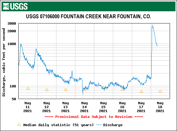
Streamflow at Fountain Creek near Fountain, CO is currently in the 99th percentile, and many gages along the Front Range are in excess of their 95th percentiles. The hydrograph below for Fountain Creek shows that rapid spike in streamflow this morning associated with the heavy rainfall yesterday.

Heavy rain was not isolated to Southern Colorado. Widespread 0.5 inches of precipitation fell up and down the Front Range, with pockets of 1.00 inches or even more. Additionally, Yuma and Kit Carson counties experienced heavy rain and even hail yesterday.

Several fire burn areas received heavy rainfall, and respective NWS offices issued Flash Flood Warnings or Flood Advisories that included portions of the Cameron Peak, East Troublesome, Calwood, Waldo Canyon and Spring Creek burn scars. A local storm report north of the Spring Creek fire reported 2.97 inches of rain in 24-hours, and MetStorm Live grids in the State Precipitation Map below show the entire Spring Creek burn scar received at least 0.5 inches of rain.

72-hour totals on the State Precipitation Map reflect how active the past few days have been, especially in the Southern and Eastern portions of the state. Many counties that were experiencing moderate to severe drought received widespread 0.5 inches of rain, and up to isolated 2+ inches in some locations, which will certainly help with drought conditions. For detailed rainfall estimates in your area for the recent few days, check out our State Precipitation Map below.

Click Here For Map Overview

The map below shows radar-estimated, rainfall gage-adjusted Quantitative Precipitation Estimates (QPE) across Colorado. The map is updated daily during the operational season (May 1 – Sep 30) by 11AM. The following six layers are currently available: 24-hour, 48-hour and 72-hour total precipitation, as well as maximum 1-hour, 2-hour and 6-hour precipitation over the past 24 hour period (to estimate where flash flooding may have occurred). The accumulation ending time is 7AM of the date shown in the bottom right corner. Also shown optionally are vulnerable fire burn areas (post 2012), which are updated throughout the season to include new, vulnerable burn areas. The home button in the top left corner resets the map to the original zoom.

SPM 05-17-2021: Heavy Rain and Flash Flood in Kit Carson County

Issue Date: Monday, May 17, 2021
Issue Time: 9:15 am MDT

Summary

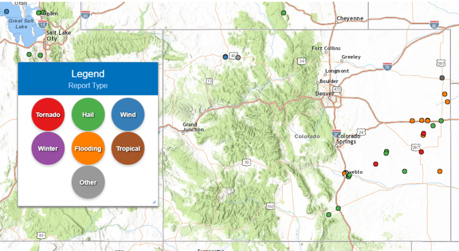
Yesterday and overnight was another active severe weather day on the Eastern Plains. A tornado was reported in Ordway, CO, as well as two funnel clouds in Kit Carson and Cheyenne Counties. Large hail was also reported the southeastern quarter of the state between I-25 and I-70. The map below shows locations of all storm reports made to the NWS in the previous 24-hours:

CoCoRaHS observers in Flagler, CO reported 3.75 inches in the 24-hour period ending at 6:00 am this morning. For this location, that amounts to a roughly 21-year Average Recurrence Interval (ARI) or just under 5% chance Annual Exceedance Probability (AEP; the chance of occurring in any given year). These estimates are based on NOAA Atlas 14 and are published online at the Hydrometeorological Design Studies Center Precipitation Frequency Data Server, found here: NOAA ATLAS 14 POINT PRECIPITATION FREQUENCY ESTIMATES: CO. Surprisingly, no flooding was reported at this station.

However, additional stations in Kit Carson county reported heavy evening and overnight rainfall totals ranging from 0.5-2.25 inches as well. Flash flooding in Downtown Stratton, CO was reported at 5:44 pm yesterday, with an estimated 1 inch of water cover the roadways. For additional rainfall estimates in your area, check out our State Precipitation Map below.

Click Here For Map Overview

The map below shows radar-estimated, rainfall gage-adjusted Quantitative Precipitation Estimates (QPE) across Colorado. The map is updated daily during the operational season (May 1 – Sep 30) by 11AM. The following six layers are currently available: 24-hour, 48-hour and 72-hour total precipitation, as well as maximum 1-hour, 2-hour and 6-hour precipitation over the past 24 hour period (to estimate where flash flooding may have occurred). The accumulation ending time is 7AM of the date shown in the bottom right corner. Also shown optionally are vulnerable fire burn areas (post 2012), which are updated throughout the season to include new, vulnerable burn areas. The home button in the top left corner resets the map to the original zoom.
SPM 05-16-2021: Heavy Rain and Tornado in Kiowa-Bent Counties

Issue Date: Sunday, May 16, 2021
Issue Time: 10:15 am MDT

Summary

The setup on Saturday was very similar to the day before in terms of precipitation across the state. In the late morning-early afternoon, isolated storms began to build up over the high elevations and make their way eastward, picking up strength. The Front Range Mountains and Urban Corridor received light precipitation associated with these storms. CoCoRaHS observers reported Trace – 0.52 inches of precipitation scattered across the region, and stratiform clouds blanketed the region most of the day.

In Kiowa and Bent Counties, a severe storm developed and produced heavy rainfall and even a short-lived tornado. The 1-hour rainfall rates for this storm were up to 1.5”/hour, with wider 0.5”/hour across much of southern Kiowa County. A CoCoRaHS observer recorded 2.07 inches in the 24-hour period ending at 7 am this morning associated with this storm. While 1.5”/hour in Eastern Colorado is significant, flooding was not reported on Saturday. For rainfall estimates in your area, check out our State Precipitation Map at the end of this post.

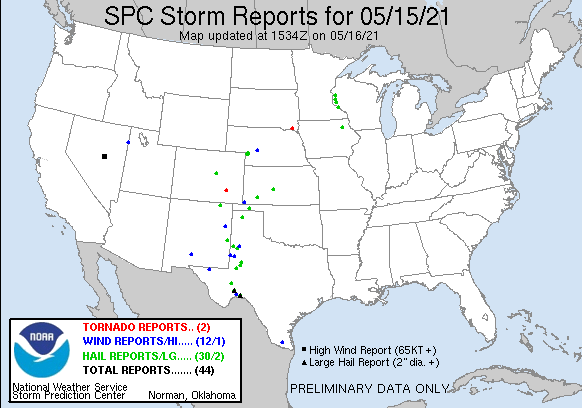
Large hail was also reported at Castlewood Canyon in Douglas County, with roads completely covered by accumulating hail. The location of both severe reports for the state are displayed on the SPC Storm Report Map below.

Click Here For Map Overview

The map below shows radar-estimated, rainfall gage-adjusted Quantitative Precipitation Estimates (QPE) across Colorado. The map is updated daily during the operational season (May 1 – Sep 30) by 11AM. The following six layers are currently available: 24-hour, 48-hour and 72-hour total precipitation, as well as maximum 1-hour, 2-hour and 6-hour precipitation over the past 24 hour period (to estimate where flash flooding may have occurred). The accumulation ending time is 7AM of the date shown in the bottom right corner. Also shown optionally are vulnerable fire burn areas (post 2012), which are updated throughout the season to include new, vulnerable burn areas. The home button in the top left corner resets the map to the original zoom.