Issue Date: Wednesday, May 19, 2021
Issue Time: 9:00 am MDT
Summary
A low-pressure system on the Colorado-New Mexico border spun up moisture into the Southeastern portion of the state yesterday, which produced heavy rain and even snow at high elevations west of Pueblo. Minor flooding reports were made along roads in Beulah, CO again as Squirrel Creek is running high. Further east, one CoCoRaHS observer in La Junta (CO-OT-42) took detailed notes describing the nature of the 1.46 inches recorded at their station yesterday:
“Rain and hail started at 2:45 pm. Pea size hail from the start of the storm. Hail and very heavy rain lasted for about 25 minutes. ground covered with about 2 inches of hail. rain continued for another hour. lots of lightning and wind. trees lost some leaves, garden plants badly damaged. water falls running off the top of the mesa. arroyos running. wonderful moisture!!”
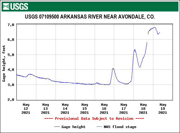
In additional to the heavy rain, minor flooding was reported at this CoCoRaHS station. Similarly, nearly every USGS gauge on the Arkansas River is at or exceeding 95th percentile streamflow for this time of year, and the Arkansas River near Avondale reached just below flood stage this morning, as seen in the plot below.
As for the rest of the state, thunderstorms brought moderate rain to the Front Range and Northeastern Plains. Some much-needed rain also fell in Southwestern Colorado. For rainfall estimates in your area, check out our State Precipitation Map below.
Click Here For Map Overview
The map below shows radar-estimated, rainfall gage-adjusted Quantitative Precipitation Estimates (QPE) across Colorado. The map is updated daily during the operational season (May 1 – Sep 30) by 11AM. The following six layers are currently available: 24-hour, 48-hour and 72-hour total precipitation, as well as maximum 1-hour, 2-hour and 6-hour precipitation over the past 24 hour period (to estimate where flash flooding may have occurred). The accumulation ending time is 7AM of the date shown in the bottom right corner. Also shown optionally are vulnerable fire burn areas (post 2012), which are updated throughout the season to include new, vulnerable burn areas. The home button in the top left corner resets the map to the original zoom.
