Issue Date: Monday, May 17, 2021
Issue Time: 9:15 am MDT
Summary
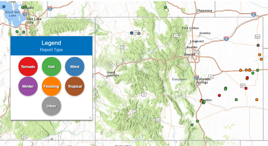
Yesterday and overnight was another active severe weather day on the Eastern Plains. A tornado was reported in Ordway, CO, as well as two funnel clouds in Kit Carson and Cheyenne Counties. Large hail was also reported the southeastern quarter of the state between I-25 and I-70. The map below shows locations of all storm reports made to the NWS in the previous 24-hours:
CoCoRaHS observers in Flagler, CO reported 3.75 inches in the 24-hour period ending at 6:00 am this morning. For this location, that amounts to a roughly 21-year Average Recurrence Interval (ARI) or just under 5% chance Annual Exceedance Probability (AEP; the chance of occurring in any given year). These estimates are based on NOAA Atlas 14 and are published online at the Hydrometeorological Design Studies Center Precipitation Frequency Data Server, found here: NOAA ATLAS 14 POINT PRECIPITATION FREQUENCY ESTIMATES: CO. Surprisingly, no flooding was reported at this station.
However, additional stations in Kit Carson county reported heavy evening and overnight rainfall totals ranging from 0.5-2.25 inches as well. Flash flooding in Downtown Stratton, CO was reported at 5:44 pm yesterday, with an estimated 1 inch of water cover the roadways. For additional rainfall estimates in your area, check out our State Precipitation Map below.
Click Here For Map Overview
The map below shows radar-estimated, rainfall gage-adjusted Quantitative Precipitation Estimates (QPE) across Colorado. The map is updated daily during the operational season (May 1 – Sep 30) by 11AM. The following six layers are currently available: 24-hour, 48-hour and 72-hour total precipitation, as well as maximum 1-hour, 2-hour and 6-hour precipitation over the past 24 hour period (to estimate where flash flooding may have occurred). The accumulation ending time is 7AM of the date shown in the bottom right corner. Also shown optionally are vulnerable fire burn areas (post 2012), which are updated throughout the season to include new, vulnerable burn areas. The home button in the top left corner resets the map to the original zoom.
