Issue Date: Sunday, May 16, 2021
Issue Time: 10:15 am MDT
Summary
The setup on Saturday was very similar to the day before in terms of precipitation across the state. In the late morning-early afternoon, isolated storms began to build up over the high elevations and make their way eastward, picking up strength. The Front Range Mountains and Urban Corridor received light precipitation associated with these storms. CoCoRaHS observers reported Trace – 0.52 inches of precipitation scattered across the region, and stratiform clouds blanketed the region most of the day.
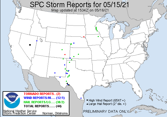
In Kiowa and Bent Counties, a severe storm developed and produced heavy rainfall and even a short-lived tornado. The 1-hour rainfall rates for this storm were up to 1.5”/hour, with wider 0.5”/hour across much of southern Kiowa County. A CoCoRaHS observer recorded 2.07 inches in the 24-hour period ending at 7 am this morning associated with this storm. While 1.5”/hour in Eastern Colorado is significant, flooding was not reported on Saturday. For rainfall estimates in your area, check out our State Precipitation Map at the end of this post.
Large hail was also reported at Castlewood Canyon in Douglas County, with roads completely covered by accumulating hail. The location of both severe reports for the state are displayed on the SPC Storm Report Map below.
Click Here For Map Overview
The map below shows radar-estimated, rainfall gage-adjusted Quantitative Precipitation Estimates (QPE) across Colorado. The map is updated daily during the operational season (May 1 – Sep 30) by 11AM. The following six layers are currently available: 24-hour, 48-hour and 72-hour total precipitation, as well as maximum 1-hour, 2-hour and 6-hour precipitation over the past 24 hour period (to estimate where flash flooding may have occurred). The accumulation ending time is 7AM of the date shown in the bottom right corner. Also shown optionally are vulnerable fire burn areas (post 2012), which are updated throughout the season to include new, vulnerable burn areas. The home button in the top left corner resets the map to the original zoom.

