SPM 07-26-2021: Relentless Monsoon Storms Continued On Sunday

Issue Date: Sunday, July 26th, 2021
Issue Time: 10:45AM MDT

Summary:

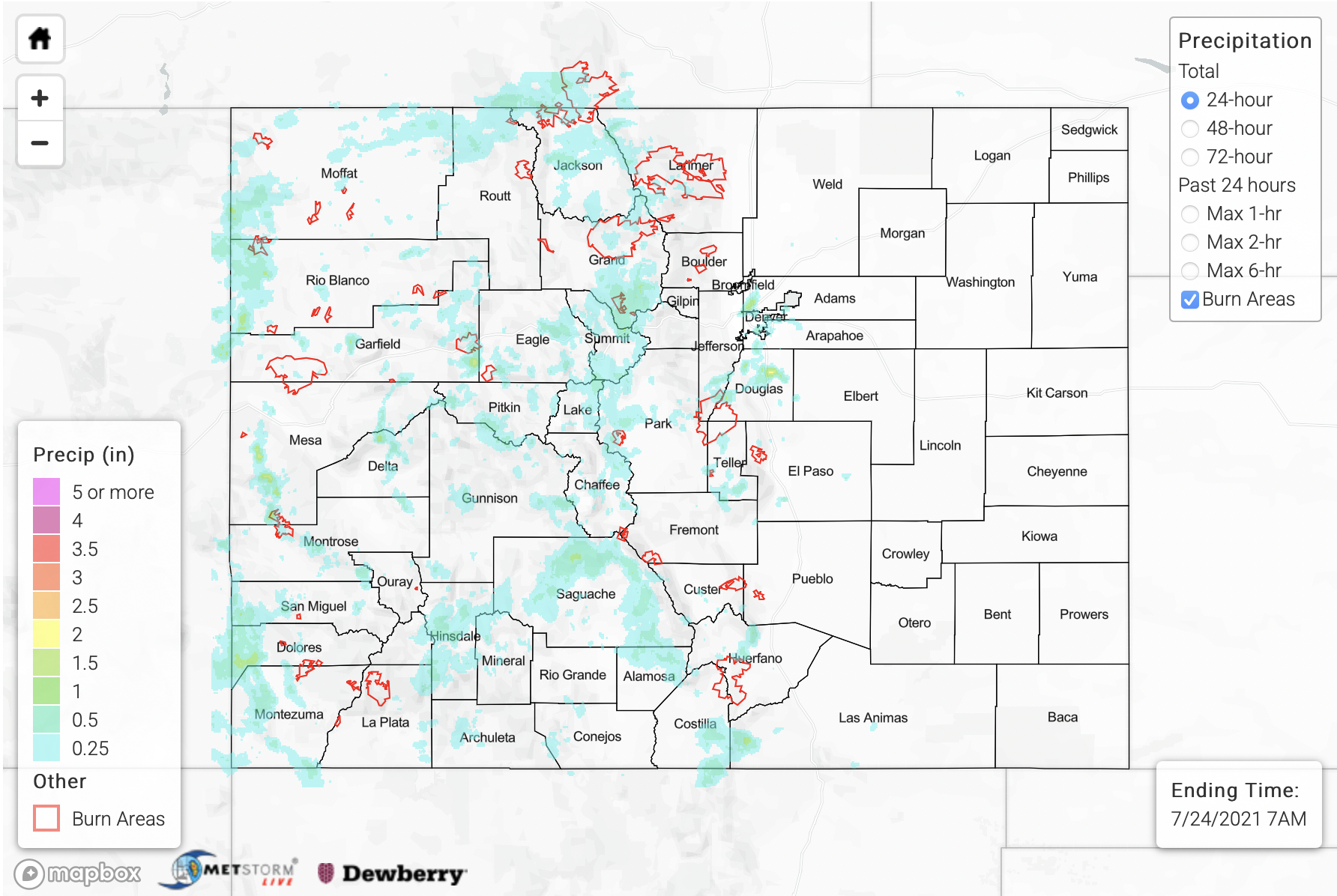
Thirty-five flood-related warnings and advisories were issued across Colorado by area National Weather Service offices on Sunday afternoon and evening. And unlike the past several days where the flood threat was generally limited to the higher terrain and foothills, heavy rainfall was also observed over the Northeast Plains and Southeast Plains. Below we separate particularly notable rainfall and flooding into 3 areas.

1) Northeast Plains and Southeast Plains. In terms of overall intensity, it appears the complex of storms over Kit Carson, Cheyenne and Kiowa counties was the strongest. Radar estimated amounts in excess of 3 inches look legitimate, as a few CoCoRaHS observations in the area reported just under 3 inches. Extremely high dewpoint temperatures exceeding 65F supported very strong instability while steering flow was strong enough to keep storms moving, slowly, but not fast enough to limit point accumulation. Most of the rainfall likely occurred in a 60-90 minute period, or even less. While no official flooding was reported with these storms, this was likely a by-product of the rural setting and limited observations across this part of Colorado.
2) Front Range and Southeast Mountains. Outflow boundaries from the storms further east ignited a somewhat surprising set of new storms along parts of the I-25 corridor, both north and south of the Palmer Divide. To the north, Mile High Flood District gages observed two separate very heavy rainfall cores near Boulder and Morrison. At the Boulder gage, about 1.70inches was recorded in only 20 minutes, making this a 100-200 year event. A CoCoRaHS gage from the area observed 2.41 inches this morning. Fortunately, the very limited spatial extent of the rainfall did not translate to a riverine flooding threat with Boulder Creek only rising a few hundred c.f.s. Further south, more widespread heavy rainfall in and around Canon City prompted numerous Flash Flood warnings. The estimated intensity of the strongest downpours was 2-2.5 inches per hour, but this fell over relatively steep terrain. Several reports of flooding came in with these storms, with the most severe likely being from south of Victor, CO, where the report read “large boulders washed onto Shelf Road Mile Marker 10”. The Arkansas River downstream of Canon City spiked from roughly 1,000 to 3,000 c.f.s. as a result of these storms. Fortunately, that was still below flood stage.
3) Western Slope Along UT border. Storms took their time to get going over the Western Slope yesterday but by evening, slow moving heavy rainfall cores were dotting the landscape along the UT border. Numerous Flash Flood warnings and Flood advisories accompanied the strongest storms, which were producing intensity of 1-1.5 inches per hour. Fortunately, flooding was not officially reported, though, just like the storms over the eastern plains, this is likely due to the very limited population and observations in the area.

Finally, looking at fire burn areas, the Pine Gulch, Grizzly Creek and Spring Creek burn scars went under Flash Flood Warnings during the afternoon and evening. There was a flooding report over the Spring Creek burn scar, noting about 8 inches of water overtopping Road 431. However, given what we know about this older burn scar, it is unclear if this was due to the fire burn itself or just from the heavy rainfall, which measured 0.94 inches in 45 minutes at a closely situated USGS gage.

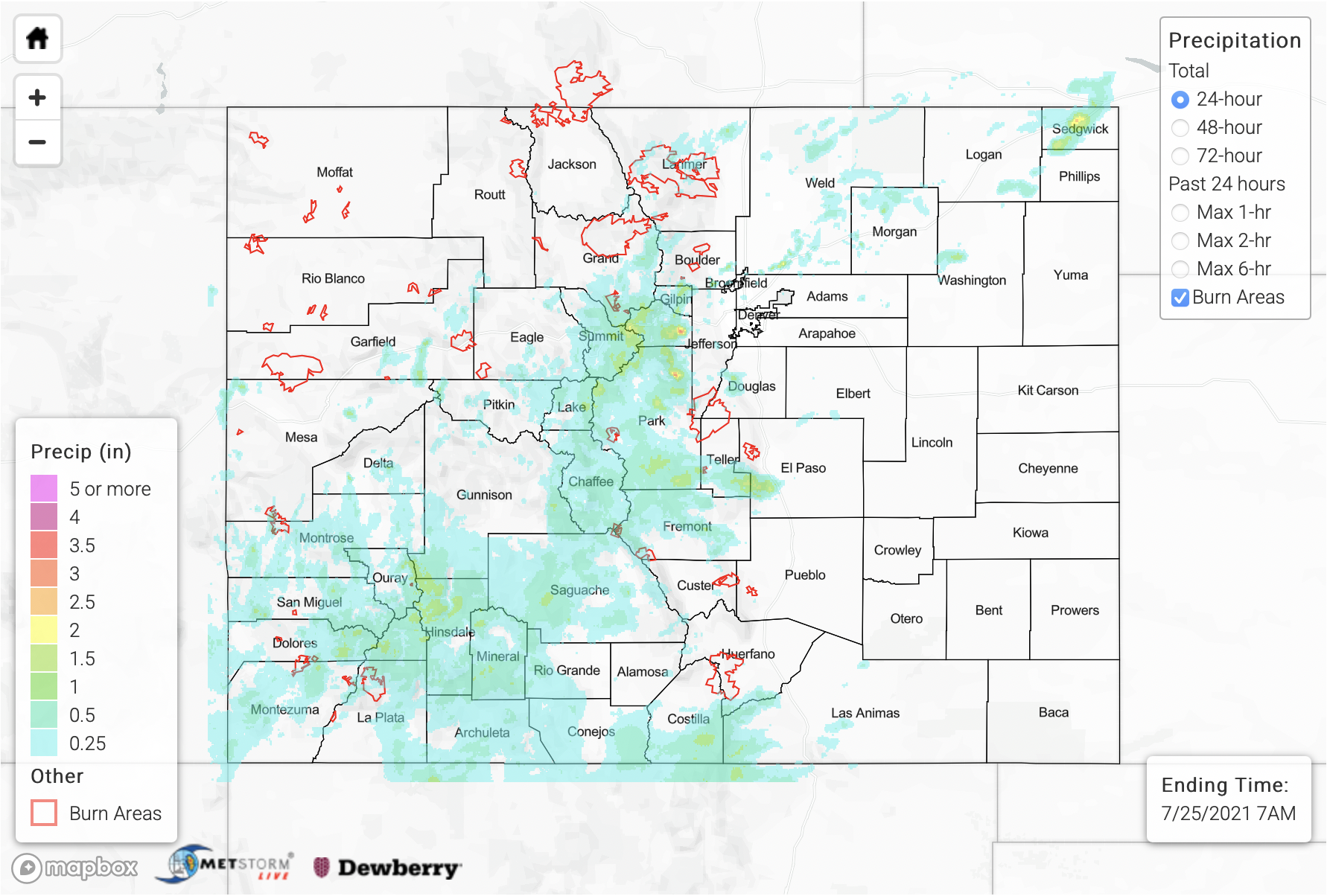
For rainfall estimates yesterday and the previous 3-days, please check out our State Precipitation Map, below.

Click Here For Map Overview

The map below shows radar-estimated, rainfall gage-adjusted Quantitative Precipitation Estimates (QPE) across Colorado. The map is updated daily during the operational season (May 1 – Sep 30) by 11AM. The following six layers are currently available: 24-hour, 48-hour and 72-hour total precipitation, as well as maximum 1-hour, 2-hour and 6-hour precipitation over the past 24 hour period (to estimate where flash flooding may have occurred). The accumulation ending time is 7AM of the date shown in the bottom right corner. Also shown optionally are vulnerable fire burn areas (post 2012), which are updated throughout the season to include new, vulnerable burn areas. The home button in the top left corner resets the map to the original zoom.

Note: The 24-hour, 48-hour and 72-hour total precipitation do not contain bias corrections today due to errors in the CoCoRaHS data. This means there may be underestimations in QPE over the southwest and southeast corners of the state.
SPM 07-25-2021: Day 5 of Heavy Rainfall and Flood Reports

Issue Date: Sunday, July 25th, 2021
Issue Time: 10:25AM MDT

Summary:

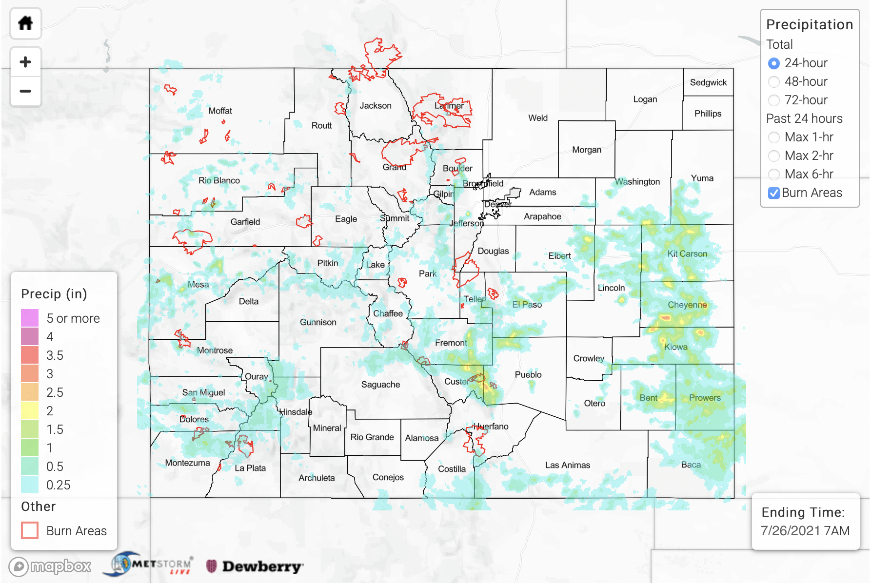
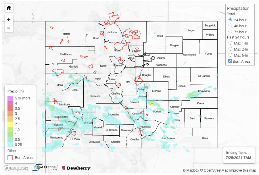
Another day with heavy rainfall, but this time the bulk of the precipitation was south of I-70 due to a cap in place further north. Over the Urban Corridor, we enjoyed a much cooler and drier day thanks to a cold front that moved through in the morning. A couple storms tried to develop in Weld County, but they dissipated as fast as they formed. The flood day began rather early with storms kicking off over the southern high terrains just after 11AM. Storms were most widespread over southwest Colorado, and they became stronger much earlier in the day when compared to the last few days. A storm popped near Redstone, CO just after noon, and it didn’t take much to cause a rockslide with the unstable soils. QPE reached up to 1.25 inches in the core of the storm according to MRMS. The Mesa Lakes SNOTEL station recorded 1.20 inches from this same storm. Dime to quarter size hail was reported with the storms that developed near Norwood, CO around 7:45PM. In total yesterday, there were 8 Flood Advisories and 12 Flood Warnings issued by the Grand Junction and Pueblo NWS offices. Below is a list of flood reports in chronological order that they were received by flood type.

County Nearest City Flood Type Details
Pitkin Redstone Debris Flow CO 133 closed with a slide blocking all lanes of traffic between MM 47.5 and Chair Mountain Dr
San Miguel Norwood Debris Flow Mud and debris slide on Highway 145 near MM 94. Highway was closed.
Montrose Uravan Debris Flow Mud and debris covered Highway 141 between MM 69 and 70. Highway was closed
Mesa Gateway Debris Flow Highway 141 closed due to mud flow between 4.4 Rd and Desert Rd
Pueblo Pinon Flash Flood Exit 108 flooded with 1.5ft of standing water
Pueblo Pinon Flash Flood Platteville Blvd closed for flooding between Painted Hill Ln and Bronco Ln
Pueblo Pinon Flash Flood Widespread flooding with 5.52 inches of rain in rainfall gage
Saguache Crestone Flash Flood One house flooded with multiple houses sandbagged near Willow Creek in the Baca Grande region


The cold front sliding south also helped to generate some very heavy rainfall early in the day with training storms over Pueblo (see the numerous flood reports in the table above). The largest observation was 5.52 inches with another observer reporting “at least three inches in my gage”. QPE from MRMS has up to 4.50 inches of rain falling over the area with MetStorm estimating about 4 inches. The front also generated some isolated, but heavy rainfall producing storms over the eastern plains. The Lincoln/Cheyenne/Kiowa County intersect received just over 2 inches of rain for the 24-hour period according to both MRMS and Stage IV data. Unfortunately, there were no observations in this area. Finally, some evening storms developed over the Raton Ridge, which dropped just over an inch of rain.

As far as burn areas, there were no reports of flooding over the FBF burn areas on Saturday though cleanup continued in Glenwood Canyon. There were Flash Flood Warnings issued for both the Pine Gulch and Grizzly Creek burn areas. Heaviest QPE were over the Pine Gulch and Spring Creek burn areas.

Check out rainfall estimates over your neighborhood from the last 24-hours by scrolling down to our State Precipitation Map below.

Click Here For Map Overview

The map below shows radar-estimated, rainfall gage-adjusted Quantitative Precipitation Estimates (QPE) across Colorado. The map is updated daily during the operational season (May 1 – Sep 30) by 11AM. The following six layers are currently available: 24-hour, 48-hour and 72-hour total precipitation, as well as maximum 1-hour, 2-hour and 6-hour precipitation over the past 24 hour period (to estimate where flash flooding may have occurred). The accumulation ending time is 7AM of the date shown in the bottom right corner. Also shown optionally are vulnerable fire burn areas (post 2012), which are updated throughout the season to include new, vulnerable burn areas. The home button in the top left corner resets the map to the original zoom.

Note: The 24-hour, 48-hour and 72-hour total precipitation do not contain bias corrections today due to errors in the CoCoRaHS data. This means there may be underestimations in QPE over the southwest and southeast corners of the state.
SPM 07-24-2021: Widespread, Heavy Rainfall Causes More Flooding Issues Across Colorado

Issue Date: Saturday, July 24th, 2021
Issue Time: 9:05AM MDT

Summary:

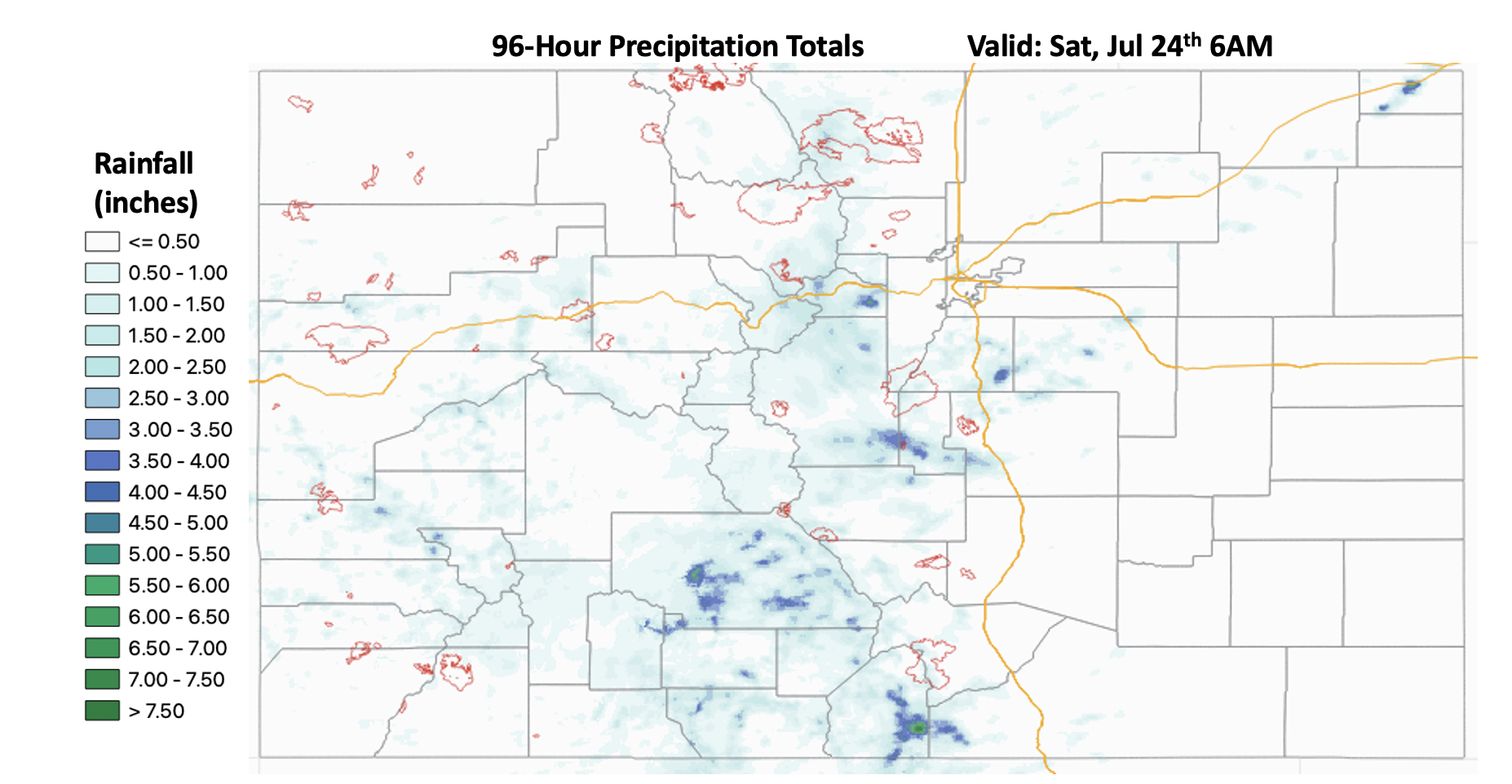
The active rainfall pattern continued for another day on Friday with well-above average moisture still being ingested over the state. It was arguably the most active rainfall day of this season due to the widespread nature of the heavy rainfall. There were 18 Flash Flood Warnings and 25 Flash Flood Advisories Issued by the three NWS offices within the state. It has been rainy to say the least, which has helped to saturate soils and make mud flow/debris slides and excessive runoff more likely over the steeper terrains. Below is a quick look at precipitation totals over the last 96 hours using MRMS gridded QPE. The extensive light shades of blue indicate between 1 and 2.50 inches of rainfall, which is very impressive.

The rainfall kicked off just before noon yesterday over the high terrains. We’ll start with what happened in the San Juan Mountains. Near Rico, CO (Dolores County) a personal weather station recorded 1.15 inches of rain in just over an hour with about 1 inch falling in 30 minutes. There was another heavy rainfall report of 1.25 inches in north, central Saguache County near Sargents. Finally, a report came in from Delta, CO where 0.80 inches cause some minor nuisance street flooding around 6:30PM last night. As far as mud flows and debris slides, there were two reports as of this morning. Ten miles north of Lake City (Gunnison County) at 6PM, a mud flow was reported that closed Highway 149 between Elk Road and County Road 149A. Just to the northwest of that at 8:44PM, a debris flow closed both lanes of Highway 50 near MM 115 just west of Cimmaron, CO.

Just to the north of the San Juan Mountains, over the Central Mountains and Grand Valley, there were two flood reports. The first was in Chaffee County just north of Buena Vista around 6:20PM. County Road 371 was washed out and two cars got stuck in the mud. Then further to the northwest in Rifle, CO (Garfield County), some urban flooding was reported with street gutters running at capacity and flooding on some of the roadways. A vigorous line of thunderstorms formed during the evening hours just to the west of Glenwood Springs (whew), but as of this morning there are no flood reports. Gridded QPE from MRMS has totals just under 2.50 inches for this storm complex. CDOT did indicate that there were some flooding issues over the Grizzly Creek burn area last night, and the eastbound lane continues to be closed this morning as they continue to clean up from a debris flow (as of 8:30AM).

The Front Range and Southeast Mountains also got hammered again yesterday. Particularly the Fremont, Park, Teller and El Paso County intersect during the evening and overnight hours. On top of widespread, heavy rainfall, the storms produced strong gusts and powerlines were reported down in Florence, CO. Slightly to the north, a rainfall gauge on top of Mount Evans recorded 2.58 inches in about one hour yesterday afternoon with the core rainfall just NW of the area. Gridded QPE indicates up to 3-4 inches of rain fell within this region. Busy day with plenty more rainfall to come over the next week.

Finally, there were some isolated storms yesterday afternoon into the evening that formed along a cold front/convergence boundary that stretched from the Palmer Ridge to the Northeast Plains. QPE values up to 2 inches were possible with the training storms that developed over Sedgwick County with max 1-hour rain rates up to 1 inch.  The highest observation in the rural area was 0.24 inches from a gage in Julesburg.

For rainfall estimates over your area from the last 24-hours, scroll down to our State Precipitation Map below.

Click Here For Map Overview

The map below shows radar-estimated, rainfall gage-adjusted Quantitative Precipitation Estimates (QPE) across Colorado. The map is updated daily during the operational season (May 1 – Sep 30) by 11AM. The following six layers are currently available: 24-hour, 48-hour and 72-hour total precipitation, as well as maximum 1-hour, 2-hour and 6-hour precipitation over the past 24 hour period (to estimate where flash flooding may have occurred). The accumulation ending time is 7AM of the date shown in the bottom right corner. Also shown optionally are vulnerable fire burn areas (post 2012), which are updated throughout the season to include new, vulnerable burn areas. The home button in the top left corner resets the map to the original zoom.

Note: The 24-hour, 48-hour and 72-hour total precipitation do not contain bias corrections today due to errors in the CoCoRaHS data. This means there may be underestimations in QPE over the southwest and southeast corners of the state.
SPM 07-23-2021: Heavy Rainfall Produces Another Round of Flash Flooding

Issue Date: Friday, July 23rd, 2021
Issue Time: 10:40AM MDT

Summary:

Well above average monsoon moisture remained over the state yesterday, which helped spark another round of widespread, heavy rainfall producing storms. Initial storm activity kicked off just after noon over the high terrains, and storms increased in both intensity and coverage by about 3PM. Multiple mountain forecast regions received over 1.25 inches of rainfall for the day, but the most widespread and highest rainfall totals were over the eastern Southeast Mountains. Fort Garland had a rainfall report of 1.75 inches, and MRMS gridded rainfall estimates are up to 2 inches (ingests the Alamosa radar). MRMS QPE indicates that a large majority of this area, including the southern San Juan Mountains and Saguache County have received around 1.75 to 2.25 inches of rainfall over the last 72-hours. More isolated totals between 3.50 and 5 inches are likely over the southeastern Southeast Mountains and Saguache County. That’s A LOT of rain, and saturated soils are taken into account for the FTB today. It will be interesting to see what dent this rainfall event/monsoon surge has in the drought over western CO considering we still have plenty of rainfall to come. For more on that, head to the FTO that was issued Thursday at the top of this page.

As far as flood reports, flash flooding was reported in Avon, CO (Eagle County) at 3:50 PM, and Nottingham Road was closed due to multiple mud flows and debris slides. A couple of the recent burn areas also recorded another day with mud flows and debris slides, and the Cameron Peak, East Troublesome and Grizzly Creek burn areas all received some sort of Flash Flood Warning/Advisory. Over the East Troublesome burn area, Highway 125 saw another debris flow around 3:40PM, which caused a closure near mile marker (MM) 7. Then over Glenwood Canyon (Grizzly Creek), two mud flows were reported at 5PM. There was a small mud flow that went across I-70 at MM 129 and a major mud flow that went across the river near MM 124 and formed a dam along the river. Gridded QPE blend has up to 1.50 inches of rain falling over the burn area itself, and nearby totals were estimated around 2.25 inches. There’s likely a slight underestimation below by MetStorm.

Additional storms developed over the Urban Corridor by early evening, which caused two flood advisories to be issued for low-lying and poorly drained areas (including roads). A CoCoRaHS observer in northern Castle Rock recorded 2.68 inches over the period of about 2 hours, which was the largest rainfall observation across the state yesterday. A nearby ALERT gage (slightly south of this observation) recorded 1.26 inches of rainfall. East Plum Creek and Cherry Creek (near Franktown) had a settle, but noticeable peak in streamflow briefly after the rainfall, but no flooding was reported as of this morning for these storms. Most rainfall activity began to wind down around midnight with some lingering showers over the western border through about 2AM into this morning. Gridded estimates for precipitation are up to 1.50 inches over the western border.

For rainfall estimates over your neighborhood the last 24-, 48- and 72-hours, scroll down to our State Precipitation Map below.

Click Here For Map Overview

The map below shows radar-estimated, rainfall gage-adjusted Quantitative Precipitation Estimates (QPE) across Colorado. The map is updated daily during the operational season (May 1 – Sep 30) by 11AM. The following six layers are currently available: 24-hour, 48-hour and 72-hour total precipitation, as well as maximum 1-hour, 2-hour and 6-hour precipitation over the past 24 hour period (to estimate where flash flooding may have occurred). The accumulation ending time is 7AM of the date shown in the bottom right corner. Also shown optionally are vulnerable fire burn areas (post 2012), which are updated throughout the season to include new, vulnerable burn areas. The home button in the top left corner resets the map to the original zoom.

Note: The 24-hour, 48-hour and 72-hour total precipitation do not contain bias corrections today due to errors in the CoCoRaHS data. This means there may be underestimations in QPE over the southwest and southeast corners of the state.