Issue Date: Friday, July 23rd, 2021
Issue Time: 10:40AM MDT
Summary:
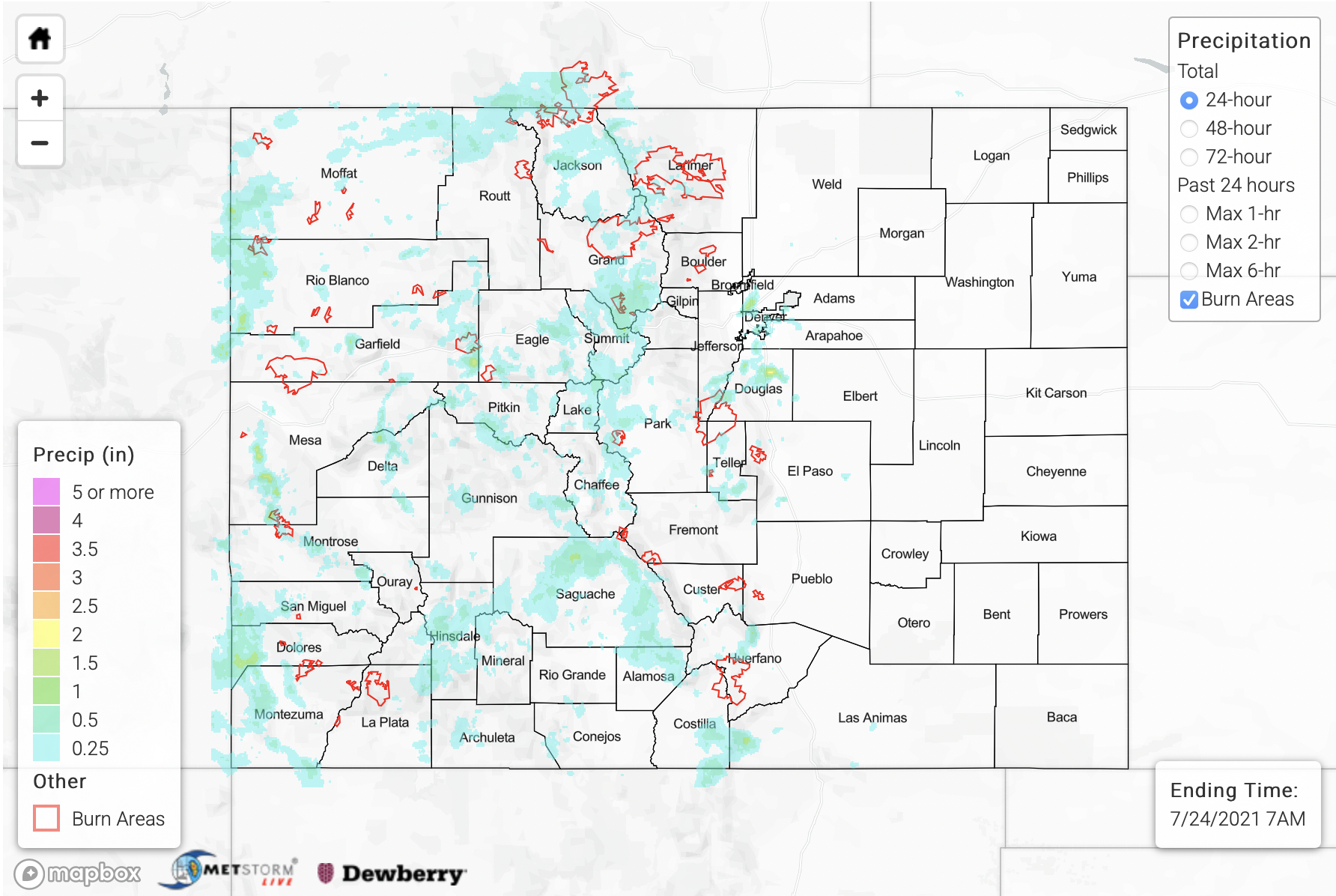
Well above average monsoon moisture remained over the state yesterday, which helped spark another round of widespread, heavy rainfall producing storms. Initial storm activity kicked off just after noon over the high terrains, and storms increased in both intensity and coverage by about 3PM. Multiple mountain forecast regions received over 1.25 inches of rainfall for the day, but the most widespread and highest rainfall totals were over the eastern Southeast Mountains. Fort Garland had a rainfall report of 1.75 inches, and MRMS gridded rainfall estimates are up to 2 inches (ingests the Alamosa radar). MRMS QPE indicates that a large majority of this area, including the southern San Juan Mountains and Saguache County have received around 1.75 to 2.25 inches of rainfall over the last 72-hours. More isolated totals between 3.50 and 5 inches are likely over the southeastern Southeast Mountains and Saguache County. That’s A LOT of rain, and saturated soils are taken into account for the FTB today. It will be interesting to see what dent this rainfall event/monsoon surge has in the drought over western CO considering we still have plenty of rainfall to come. For more on that, head to the FTO that was issued Thursday at the top of this page.
As far as flood reports, flash flooding was reported in Avon, CO (Eagle County) at 3:50 PM, and Nottingham Road was closed due to multiple mud flows and debris slides. A couple of the recent burn areas also recorded another day with mud flows and debris slides, and the Cameron Peak, East Troublesome and Grizzly Creek burn areas all received some sort of Flash Flood Warning/Advisory. Over the East Troublesome burn area, Highway 125 saw another debris flow around 3:40PM, which caused a closure near mile marker (MM) 7. Then over Glenwood Canyon (Grizzly Creek), two mud flows were reported at 5PM. There was a small mud flow that went across I-70 at MM 129 and a major mud flow that went across the river near MM 124 and formed a dam along the river. Gridded QPE blend has up to 1.50 inches of rain falling over the burn area itself, and nearby totals were estimated around 2.25 inches. There’s likely a slight underestimation below by MetStorm.
Additional storms developed over the Urban Corridor by early evening, which caused two flood advisories to be issued for low-lying and poorly drained areas (including roads). A CoCoRaHS observer in northern Castle Rock recorded 2.68 inches over the period of about 2 hours, which was the largest rainfall observation across the state yesterday. A nearby ALERT gage (slightly south of this observation) recorded 1.26 inches of rainfall. East Plum Creek and Cherry Creek (near Franktown) had a settle, but noticeable peak in streamflow briefly after the rainfall, but no flooding was reported as of this morning for these storms. Most rainfall activity began to wind down around midnight with some lingering showers over the western border through about 2AM into this morning. Gridded estimates for precipitation are up to 1.50 inches over the western border.
For rainfall estimates over your neighborhood the last 24-, 48- and 72-hours, scroll down to our State Precipitation Map below.
Click Here For Map Overview
Note: The 24-hour, 48-hour and 72-hour total precipitation do not contain bias corrections today due to errors in the CoCoRaHS data. This means there may be underestimations in QPE over the southwest and southeast corners of the state.
