Issue Date: Sunday, July 25th, 2021
Issue Time: 10:25AM MDT
Summary:
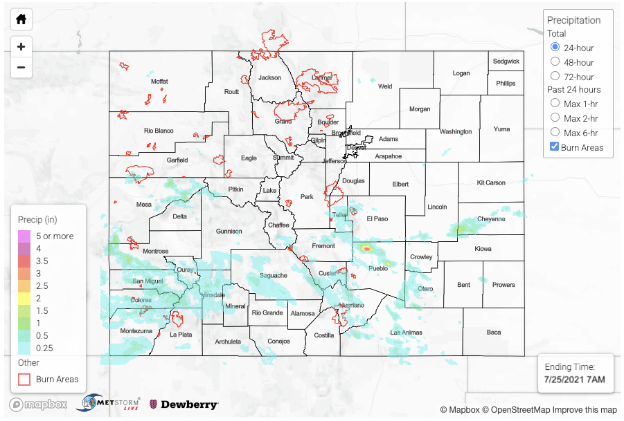
Another day with heavy rainfall, but this time the bulk of the precipitation was south of I-70 due to a cap in place further north. Over the Urban Corridor, we enjoyed a much cooler and drier day thanks to a cold front that moved through in the morning. A couple storms tried to develop in Weld County, but they dissipated as fast as they formed. The flood day began rather early with storms kicking off over the southern high terrains just after 11AM. Storms were most widespread over southwest Colorado, and they became stronger much earlier in the day when compared to the last few days. A storm popped near Redstone, CO just after noon, and it didn’t take much to cause a rockslide with the unstable soils. QPE reached up to 1.25 inches in the core of the storm according to MRMS. The Mesa Lakes SNOTEL station recorded 1.20 inches from this same storm. Dime to quarter size hail was reported with the storms that developed near Norwood, CO around 7:45PM. In total yesterday, there were 8 Flood Advisories and 12 Flood Warnings issued by the Grand Junction and Pueblo NWS offices. Below is a list of flood reports in chronological order that they were received by flood type.
| County | Nearest City | Flood Type | Details |
| Pitkin | Redstone | Debris Flow | CO 133 closed with a slide blocking all lanes of traffic between MM 47.5 and Chair Mountain Dr |
| San Miguel | Norwood | Debris Flow | Mud and debris slide on Highway 145 near MM 94. Highway was closed. |
| Montrose | Uravan | Debris Flow | Mud and debris covered Highway 141 between MM 69 and 70. Highway was closed |
| Mesa | Gateway | Debris Flow | Highway 141 closed due to mud flow between 4.4 Rd and Desert Rd |
| Pueblo | Pinon | Flash Flood | Exit 108 flooded with 1.5ft of standing water |
| Pueblo | Pinon | Flash Flood | Platteville Blvd closed for flooding between Painted Hill Ln and Bronco Ln |
| Pueblo | Pinon | Flash Flood | Widespread flooding with 5.52 inches of rain in rainfall gage |
| Saguache | Crestone | Flash Flood | One house flooded with multiple houses sandbagged near Willow Creek in the Baca Grande region |
The cold front sliding south also helped to generate some very heavy rainfall early in the day with training storms over Pueblo (see the numerous flood reports in the table above). The largest observation was 5.52 inches with another observer reporting “at least three inches in my gage”. QPE from MRMS has up to 4.50 inches of rain falling over the area with MetStorm estimating about 4 inches. The front also generated some isolated, but heavy rainfall producing storms over the eastern plains. The Lincoln/Cheyenne/Kiowa County intersect received just over 2 inches of rain for the 24-hour period according to both MRMS and Stage IV data. Unfortunately, there were no observations in this area. Finally, some evening storms developed over the Raton Ridge, which dropped just over an inch of rain.
As far as burn areas, there were no reports of flooding over the FBF burn areas on Saturday though cleanup continued in Glenwood Canyon. There were Flash Flood Warnings issued for both the Pine Gulch and Grizzly Creek burn areas. Heaviest QPE were over the Pine Gulch and Spring Creek burn areas.
Check out rainfall estimates over your neighborhood from the last 24-hours by scrolling down to our State Precipitation Map below.
Click Here For Map Overview
Note: The 24-hour, 48-hour and 72-hour total precipitation do not contain bias corrections today due to errors in the CoCoRaHS data. This means there may be underestimations in QPE over the southwest and southeast corners of the state.
