Issue Date: Saturday, July 24th, 2021
Issue Time: 9:05AM MDT
Summary:
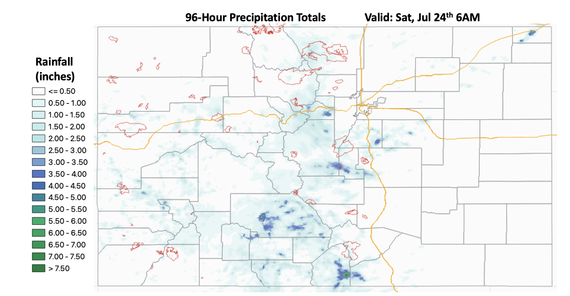
The active rainfall pattern continued for another day on Friday with well-above average moisture still being ingested over the state. It was arguably the most active rainfall day of this season due to the widespread nature of the heavy rainfall. There were 18 Flash Flood Warnings and 25 Flash Flood Advisories Issued by the three NWS offices within the state. It has been rainy to say the least, which has helped to saturate soils and make mud flow/debris slides and excessive runoff more likely over the steeper terrains. Below is a quick look at precipitation totals over the last 96 hours using MRMS gridded QPE. The extensive light shades of blue indicate between 1 and 2.50 inches of rainfall, which is very impressive.

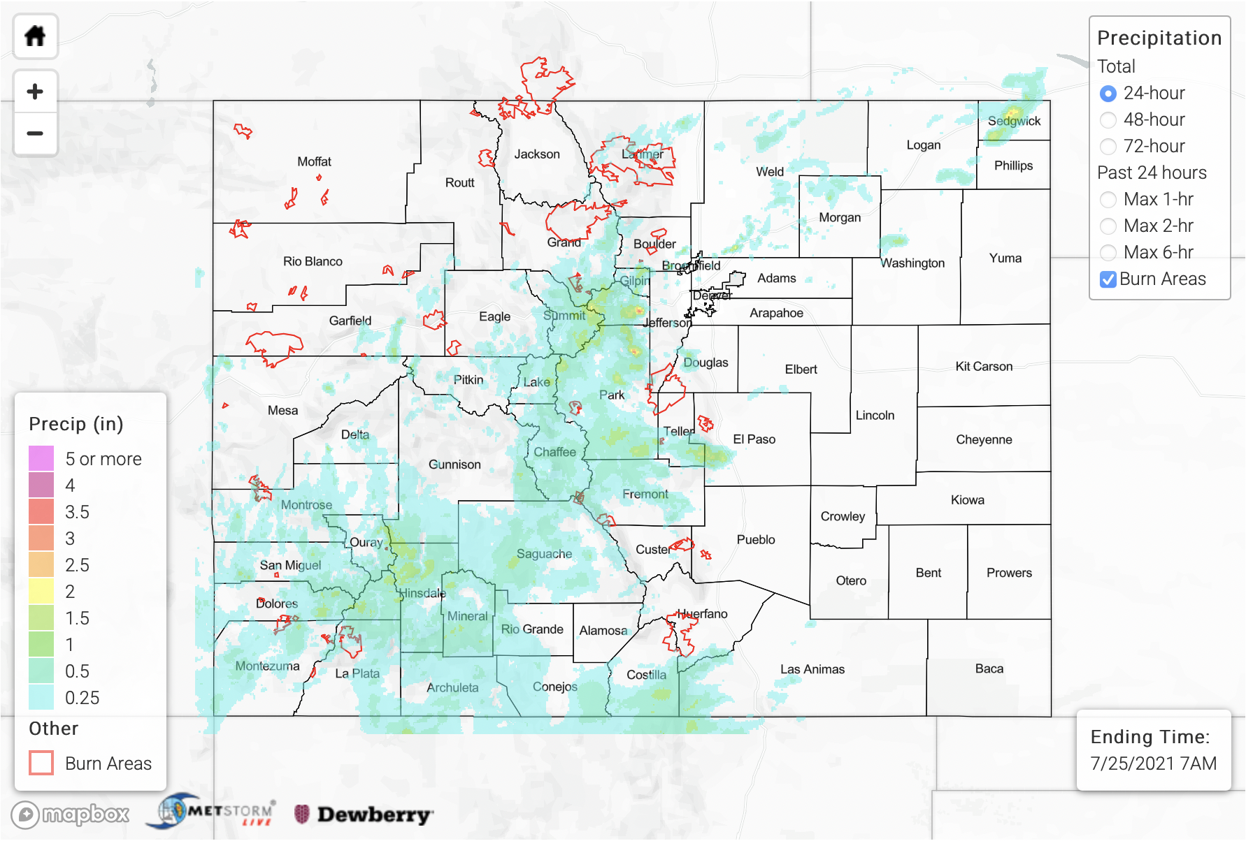
The rainfall kicked off just before noon yesterday over the high terrains. We’ll start with what happened in the San Juan Mountains. Near Rico, CO (Dolores County) a personal weather station recorded 1.15 inches of rain in just over an hour with about 1 inch falling in 30 minutes. There was another heavy rainfall report of 1.25 inches in north, central Saguache County near Sargents. Finally, a report came in from Delta, CO where 0.80 inches cause some minor nuisance street flooding around 6:30PM last night. As far as mud flows and debris slides, there were two reports as of this morning. Ten miles north of Lake City (Gunnison County) at 6PM, a mud flow was reported that closed Highway 149 between Elk Road and County Road 149A. Just to the northwest of that at 8:44PM, a debris flow closed both lanes of Highway 50 near MM 115 just west of Cimmaron, CO.
Just to the north of the San Juan Mountains, over the Central Mountains and Grand Valley, there were two flood reports. The first was in Chaffee County just north of Buena Vista around 6:20PM. County Road 371 was washed out and two cars got stuck in the mud. Then further to the northwest in Rifle, CO (Garfield County), some urban flooding was reported with street gutters running at capacity and flooding on some of the roadways. A vigorous line of thunderstorms formed during the evening hours just to the west of Glenwood Springs (whew), but as of this morning there are no flood reports. Gridded QPE from MRMS has totals just under 2.50 inches for this storm complex. CDOT did indicate that there were some flooding issues over the Grizzly Creek burn area last night, and the eastbound lane continues to be closed this morning as they continue to clean up from a debris flow (as of 8:30AM).
The Front Range and Southeast Mountains also got hammered again yesterday. Particularly the Fremont, Park, Teller and El Paso County intersect during the evening and overnight hours. On top of widespread, heavy rainfall, the storms produced strong gusts and powerlines were reported down in Florence, CO. Slightly to the north, a rainfall gauge on top of Mount Evans recorded 2.58 inches in about one hour yesterday afternoon with the core rainfall just NW of the area. Gridded QPE indicates up to 3-4 inches of rain fell within this region. Busy day with plenty more rainfall to come over the next week.
Finally, there were some isolated storms yesterday afternoon into the evening that formed along a cold front/convergence boundary that stretched from the Palmer Ridge to the Northeast Plains. QPE values up to 2 inches were possible with the training storms that developed over Sedgwick County with max 1-hour rain rates up to 1 inch. The highest observation in the rural area was 0.24 inches from a gage in Julesburg.
For rainfall estimates over your area from the last 24-hours, scroll down to our State Precipitation Map below.
Click Here For Map Overview
Note: The 24-hour, 48-hour and 72-hour total precipitation do not contain bias corrections today due to errors in the CoCoRaHS data. This means there may be underestimations in QPE over the southwest and southeast corners of the state.
