SPM 07-30-2021: Debris Flows Near Redstone in Pitkin County

Issue Date: Friday, July 30th, 2021
Issue Time: 11AM MDT

Summary:

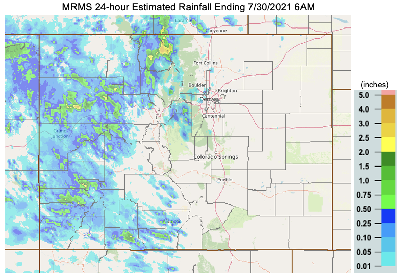
Another day with heavy rainfall, and another day with plenty of Flash Flood Advisories and Warnings issued by NWS Boulder and Grand Junction. Yesterday, there were 27 advisories or warnings related to flooding issued by both NWS offices. The Pine Gulch, Grizzly Creek, East Troublesome and Cameron Peak burn areas were included in this count, but thankfully there were no flood reports over the recent burn scars as of this morning. The USGS gage system installed around the Grizzly Creek burn area recorded between 0.83 and 2.01 inches of rainfall at 5 of the 7 gages, and I-70 remains closed this morning. So, perhaps there were a couple mud flows that weren’t officially recorded? CDOT’s official Facebook page alludes to some flooding issues on I-70. The other USGS gage system installed around the East Troublesome burn area recorded up to 0.47 inches of rainfall.

The lone official flood reports for the day were over Pitkin County where there were several debris flows reported along Highway 133 near Redstone around 5PM MDT. This is a problematic area that has already seen debris slides this season. The debris depth of one of the slides was 7 to 8 feet, which stranded motorists. Radar estimated rainfall in the area was just under 1.50 inches with a nearby CoCoRaHS report of 0.97 inches.

There were even a couple severe thunderstorms over western Colorado yesterday, which produced hail up to 1 inch in diameter and gusts around 55 mph. The most severe of these thunderstorms was in Jackson County. Overall, several CoCoRaHS stations across western Colorado reported at least an inch of rainfall, so it was another good soaking for some.

The heaviest rainfall occurred in eastern Jackson/western Larimer County along the northern Front Range mountains. Radar estimated rainfall from MRMS is up to 3.50 inches with MetStorm indicating up to 1.50 inches. The highest observation in the area was 0.77 inches, but south of rainfall core. The truth is probably somewhere in the middle

To see rainfall estimates over your area the last 24-hours, scroll down to our State Precipitation Map below [note: due to a technical issue with the normal product, MRMS estimated rainfall is shown below].
 

SPM 07-29-2021: Heavy Rainfall over Western Colorado Produces Two Debris Flows

Issue Date: Thursday, July 29th, 2021
Issue Time: 10:35AM MDT

Summary:

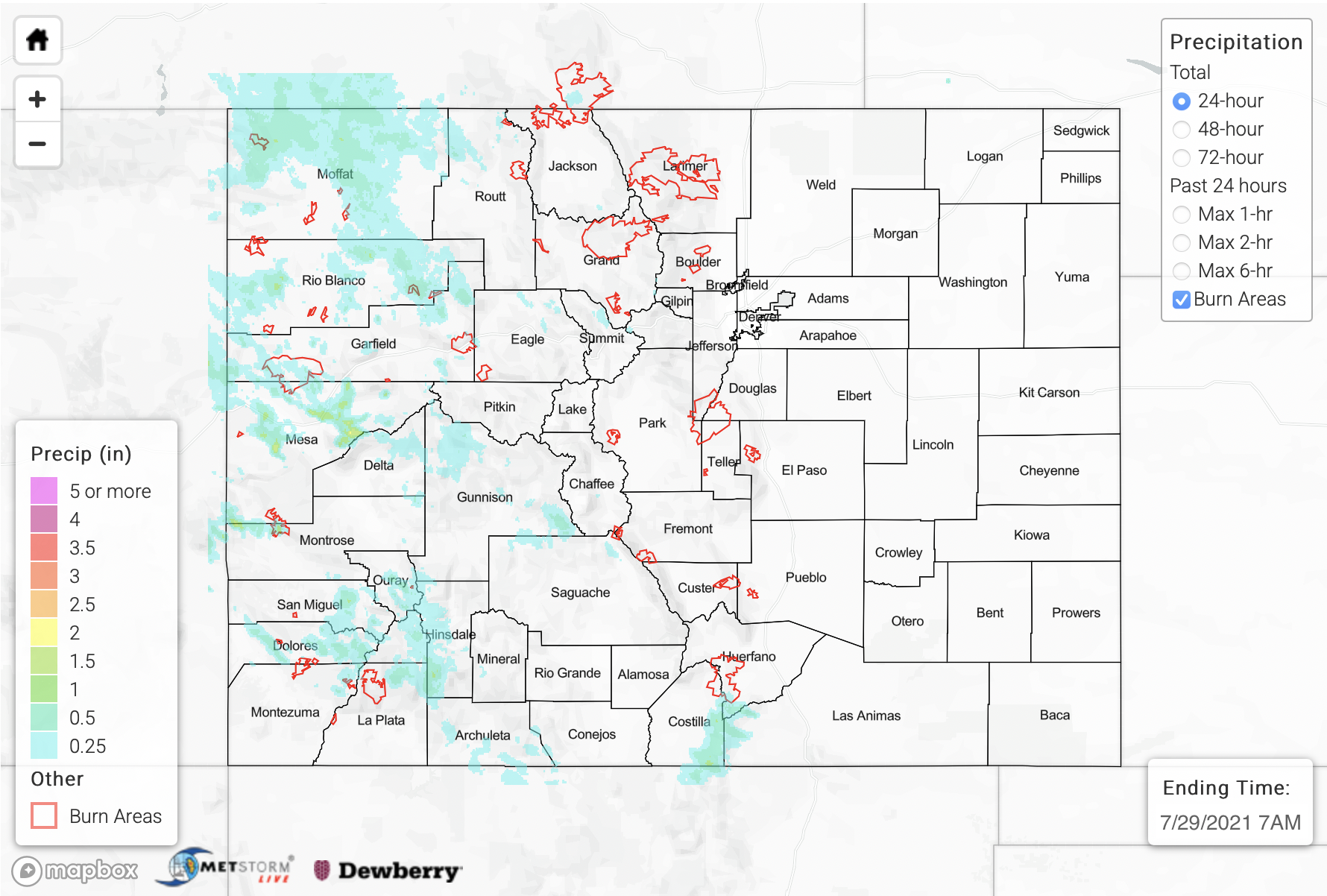
It has been a busy wet season with the last 13 days in a row receiving a flood threat, and yesterday was more of the same. So, we’ll just jump right in. On Wednesday, the Southeast Mountain/Raton Ridge intersect saw a few rounds of heavy rainfall producing storms due to slightly better moisture and instability across the southern border. Gages in the area recorded up to 0.55 inches of rainfall with storms lasting from about 1PM to 6:30PM. Radar estimated rainfall indicates between 1 and 2 inches of precipitation in the storm cores depending on the dataset used. As of this morning, flooding was not reported with these storms.

While it was pretty quiet to the east of the Continental Divide, outside of the storms discussed above, higher instability and moisture availability over western Colorado helped to generate some stronger storms that produced some torrential downpours and flooding issues. Slower steering flows to the west/northwest also aided in increasing local precipitation totals and the flood threat. Grand Junction also saw day 4 of measurable precipitation with two heavy rainfall reports (1.17 and 1.11 inches) over the west side of town that cause some street flooding. Gusts (~60 mph) from this severe thunderstorm caused some large branches to come down on the east side of town, and it also produced 1 inch hail. There was a debris flow at Exit 46 (Cameo) on I-70 at 7:20PM that closed both lanes of the highway. Near this debris flow, 1.05 inches of rainfall was observed by the public. A Flash Flood Warning was issued for the Pine Gulch burn area with this storm complex, but as of this morning, no flooding was reported.

Further south, there was another debris flow across Highway 145 near Placerville, CO (eastern San Miguel County). Radar estimated rainfall was up to 1.30 inches over this area. Finally, a CoCoRaHS stie in southern Archuleta County recorded 1.06 inches of rainfall, and once again lack of radars in the area likely underestimated rainfall over this region. Rainfall lingered over the Northwest Slope through about 2AM, but it was more stratiform in nature, so there were no flooding concerns. Tune into the FTO this afternoon to see how this ongoing rainfall has impacted the drought map.

To see rainfall estimates over your neighborhood over the last 24- to 72-hours, scroll down to our State Precipitation Map below.

Click Here For Map Overview

The map below shows radar-estimated, rainfall gage-adjusted Quantitative Precipitation Estimates (QPE) across Colorado. The map is updated daily during the operational season (May 1 – Sep 30) by 11AM. The following six layers are currently available: 24-hour, 48-hour and 72-hour total precipitation, as well as maximum 1-hour, 2-hour and 6-hour precipitation over the past 24 hour period (to estimate where flash flooding may have occurred). The accumulation ending time is 7AM of the date shown in the bottom right corner. Also shown optionally are vulnerable fire burn areas (post 2012), which are updated throughout the season to include new, vulnerable burn areas. The home button in the top left corner resets the map to the original zoom.

Note: The 24-hour, 48-hour and 72-hour total precipitation do not contain bias corrections today due to errors in the CoCoRaHS data. This means there may be underestimations in QPE over the southwest and southeast corners of the state.

SPM 07-28-2021: Heavy Rainfall Over San Juan Mountains

Issue Date: Wednesday, July 28th, 2021
Issue Time: 11AM MDT

Summary:

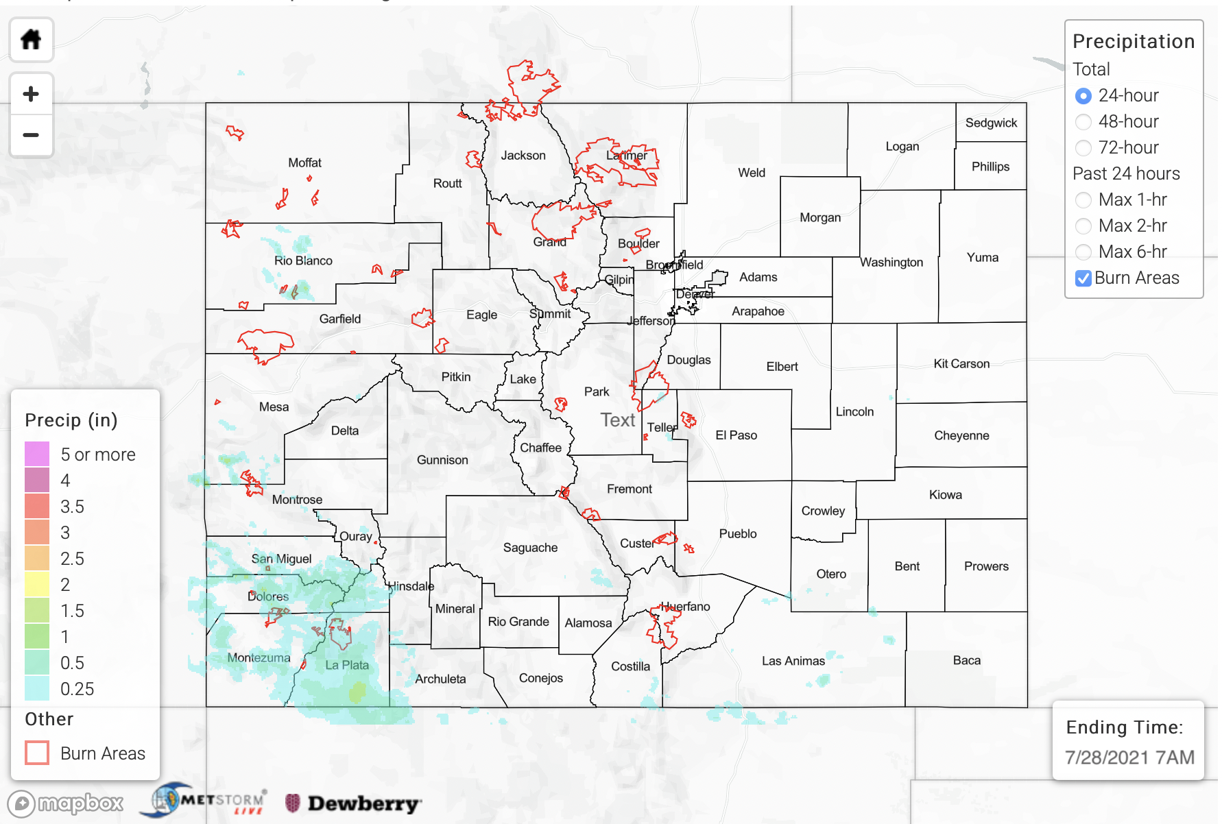
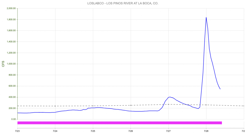
Although rainfall coverage decreased somewhat compared to previous active days, with plenty of monsoonal moisture around, scattered to numerous thunderstorms were once again the norm over parts of the San Juan Mountains. The most impressive complex of storms occurred late in the evening along the New Mexico border where 60-90 minutes of heavy rainfall prompted a Flood Advisory for the area south of Durango. The Durango-La Plata County Airport gage measured a total of 1.34 inches, and best estimates suggest about 1 inch per hour as the peak intensity of the rainfall. However, because the rainfall occurred over a relatively large area, significant runoff resulted in several spikes of regional streams and rivers. The Los Pinos River (at La Boca, shown below) went from about 200 cfs at 7PM to 1,800 cfs at midnight. Just to the west, the Florida River at Bondad went from about 60 cfs at 6PM to over 1,000 cfs at midnight. And just downstream of Bondad where the Florida meets the Animas River, a spike of several thousand cfs was noted in the evening hours. Keep in mind these estimates are very preliminary and could be adjusted later. However, the flows appear to be consistent with the areal coverage and intensity of heavy rainfall observed yesterday.

Elsewhere, another more isolated storm prompted a Flash Flood Warning to the northeast of the town of Dolores where up to 1.0 inch of rainfall occurred. Finally, as more of a fun fact, Grand Junction received measurable rainfall for the third day in a row, although it was a rather unimpressive 0.01 inch.

For rainfall estimates yesterday and the previous 3-days, please check out our State Precipitation Map, below. Please note that we are aware of underestimates in peak rainfall intensity over the southwest part of the state. This is likely arising from poor radar coverage in the area.

Click Here For Map Overview

The map below shows radar-estimated, rainfall gage-adjusted Quantitative Precipitation Estimates (QPE) across Colorado. The map is updated daily during the operational season (May 1 – Sep 30) by 11AM. The following six layers are currently available: 24-hour, 48-hour and 72-hour total precipitation, as well as maximum 1-hour, 2-hour and 6-hour precipitation over the past 24 hour period (to estimate where flash flooding may have occurred). The accumulation ending time is 7AM of the date shown in the bottom right corner. Also shown optionally are vulnerable fire burn areas (post 2012), which are updated throughout the season to include new, vulnerable burn areas. The home button in the top left corner resets the map to the original zoom.

SPM 07-27-2021: Heavy Rainfall Near the Southern Colorado Border

Issue Date: Tuesday, July 27th, 2021
Issue Time: 9:25AM MDT

Summary:

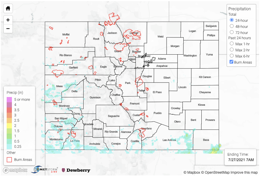
Finally, a bit of a lull in the widespread, heavy rainfall, although there were still some impressive totals across the southern portion of the state. Storms began on Monday over the San Juan Mountains and Raton Ridge/Southeast Mountain intersect just afternoon noon. By mid-afternoon a couple additional thunderstorms popped over the Flat Top region (Rio Blanco/Garfield County line). Gridded QPE indicates up to 0.80 inches of rain fell with this batch of storms. Better moisture and dynamics were south, so storms were more widespread and stronger over this region, especially west. SNOTEL stations over the San Juan Mountains had up to 0.50 inches of rainfall measured with the highest CoCoRaHS observation in La Plata County, which measured 1.22 inches for the 24-hour period. Around 0.61 inches in 30 minutes was observed from this storm just south of Durango during the early evening hours. Grand Junction got measurable rainfall for the second day in a row as storms rolled westward into the valley during the evening hours. The official measurement for yesterday was only 0.01 inches (airport), but QPE indicates up to 1.25 inches fell in the storm core just southwest of town over the Colorado National Monument, and 1.27 inches was recorded in western Grand Mesa National Forest. Thankfully, there were no flood reports over western CO on Monday.

Looking into rainfall totals over the Southeast Mountains, the initial set of storms described above produced just under 1 inch of rainfall. A second storm over the northern tip of Costilla County around 2PM produced totals up to 1.25 inches according to MRMS QPE. The highest observation over the region was near Fort Garland, which recorded 1.09 inches. A more robust line of storms developed over the eastern Raton Ridge by mid-afternoon that lasted through the early evening. An outflow boundary from these storms initiated a lone storm over Baca County with heavier rainfall south and east of the border. Gridded MRMS QPE suggests up to 2.50 inches of rainfall in the storm cores over these remote and poorly gaged area. This seems about right with a CoCoRaHS gage just south of Baca County in the OK panhandle recording 2.95 inches.

There was no flooding reporting on Monday as of the time of this posting. Scroll down below to check out rainfall estimates from the last 24-hours over your area from our State Precipitation Map. Note that precipitation totals over southwest Colorado are more than likely underestimated today.

Click Here For Map Overview

The map below shows radar-estimated, rainfall gage-adjusted Quantitative Precipitation Estimates (QPE) across Colorado. The map is updated daily during the operational season (May 1 – Sep 30) by 11AM. The following six layers are currently available: 24-hour, 48-hour and 72-hour total precipitation, as well as maximum 1-hour, 2-hour and 6-hour precipitation over the past 24 hour period (to estimate where flash flooding may have occurred). The accumulation ending time is 7AM of the date shown in the bottom right corner. Also shown optionally are vulnerable fire burn areas (post 2012), which are updated throughout the season to include new, vulnerable burn areas. The home button in the top left corner resets the map to the original zoom.

Note: The 24-hour, 48-hour and 72-hour total precipitation do not contain bias corrections today due to errors in the CoCoRaHS data. This means there may be underestimations in QPE over the southwest and southeast corners of the state.