Issue Date: Tuesday, July 27th, 2021
Issue Time: 9:25AM MDT
Summary:
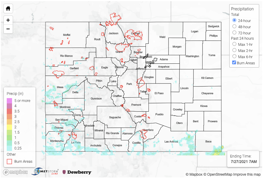
Finally, a bit of a lull in the widespread, heavy rainfall, although there were still some impressive totals across the southern portion of the state. Storms began on Monday over the San Juan Mountains and Raton Ridge/Southeast Mountain intersect just afternoon noon. By mid-afternoon a couple additional thunderstorms popped over the Flat Top region (Rio Blanco/Garfield County line). Gridded QPE indicates up to 0.80 inches of rain fell with this batch of storms. Better moisture and dynamics were south, so storms were more widespread and stronger over this region, especially west. SNOTEL stations over the San Juan Mountains had up to 0.50 inches of rainfall measured with the highest CoCoRaHS observation in La Plata County, which measured 1.22 inches for the 24-hour period. Around 0.61 inches in 30 minutes was observed from this storm just south of Durango during the early evening hours. Grand Junction got measurable rainfall for the second day in a row as storms rolled westward into the valley during the evening hours. The official measurement for yesterday was only 0.01 inches (airport), but QPE indicates up to 1.25 inches fell in the storm core just southwest of town over the Colorado National Monument, and 1.27 inches was recorded in western Grand Mesa National Forest. Thankfully, there were no flood reports over western CO on Monday.
Looking into rainfall totals over the Southeast Mountains, the initial set of storms described above produced just under 1 inch of rainfall. A second storm over the northern tip of Costilla County around 2PM produced totals up to 1.25 inches according to MRMS QPE. The highest observation over the region was near Fort Garland, which recorded 1.09 inches. A more robust line of storms developed over the eastern Raton Ridge by mid-afternoon that lasted through the early evening. An outflow boundary from these storms initiated a lone storm over Baca County with heavier rainfall south and east of the border. Gridded MRMS QPE suggests up to 2.50 inches of rainfall in the storm cores over these remote and poorly gaged area. This seems about right with a CoCoRaHS gage just south of Baca County in the OK panhandle recording 2.95 inches.
There was no flooding reporting on Monday as of the time of this posting. Scroll down below to check out rainfall estimates from the last 24-hours over your area from our State Precipitation Map. Note that precipitation totals over southwest Colorado are more than likely underestimated today.
Click Here For Map Overview
Note: The 24-hour, 48-hour and 72-hour total precipitation do not contain bias corrections today due to errors in the CoCoRaHS data. This means there may be underestimations in QPE over the southwest and southeast corners of the state.
