Issue Date: Friday, July 30th, 2021
Issue Time: 11AM MDT
Summary:
Another day with heavy rainfall, and another day with plenty of Flash Flood Advisories and Warnings issued by NWS Boulder and Grand Junction. Yesterday, there were 27 advisories or warnings related to flooding issued by both NWS offices. The Pine Gulch, Grizzly Creek, East Troublesome and Cameron Peak burn areas were included in this count, but thankfully there were no flood reports over the recent burn scars as of this morning. The USGS gage system installed around the Grizzly Creek burn area recorded between 0.83 and 2.01 inches of rainfall at 5 of the 7 gages, and I-70 remains closed this morning. So, perhaps there were a couple mud flows that weren’t officially recorded? CDOT’s official Facebook page alludes to some flooding issues on I-70. The other USGS gage system installed around the East Troublesome burn area recorded up to 0.47 inches of rainfall.
The lone official flood reports for the day were over Pitkin County where there were several debris flows reported along Highway 133 near Redstone around 5PM MDT. This is a problematic area that has already seen debris slides this season. The debris depth of one of the slides was 7 to 8 feet, which stranded motorists. Radar estimated rainfall in the area was just under 1.50 inches with a nearby CoCoRaHS report of 0.97 inches.
There were even a couple severe thunderstorms over western Colorado yesterday, which produced hail up to 1 inch in diameter and gusts around 55 mph. The most severe of these thunderstorms was in Jackson County. Overall, several CoCoRaHS stations across western Colorado reported at least an inch of rainfall, so it was another good soaking for some.
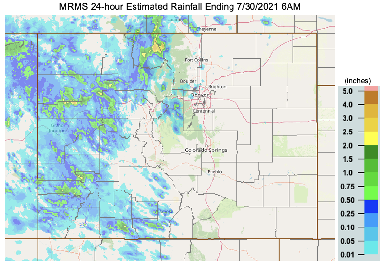
The heaviest rainfall occurred in eastern Jackson/western Larimer County along the northern Front Range mountains. Radar estimated rainfall from MRMS is up to 3.50 inches with MetStorm indicating up to 1.50 inches. The highest observation in the area was 0.77 inches, but south of rainfall core. The truth is probably somewhere in the middle
To see rainfall estimates over your area the last 24-hours, scroll down to our State Precipitation Map below [note: due to a technical issue with the normal product, MRMS estimated rainfall is shown below].