SPM 08-03-2021: Heavy Rain Across High Elevations, Flooding in Central and Southeast Mountains

Issue Date: Tuesday, August 3rd, 2021
Issue Time: 9:15 AM MDT

Summary:

Another day of ample monsoonal moisture brought several rounds of widespread thunderstorm coverage to the western half of the state yesterday, amplified by the west-east passage of an upper-level trough imbedded in the moisture plume. Storms kicked off early along the Colorado-Utah border in the Grand Valley and Southwest Slope with a general eastward movement before dissipating in the late morning. By early afternoon, thunderstorms had developed again – warranting flood advisories and warnings to be issued across the Northern, Central, and Southeast Mountains, as well as the Grand Valley and Southwest Slope. Many of the major burn scars in Colorado had flood warnings issued, including the Cameron Peak, East Troublesome, William’s Fork, Grizzly Peak, Decker, and Pine Gulch fires after radar indicated heavy rainfall potential.

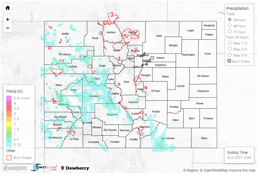
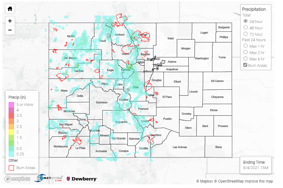
Flooding was reported on the Spring Creek burn scar in the Southeast Mountains. Highway 12 was reported to be overtopped with water, though no debris. This was after two flash flood warnings were issued for both the northern and southern portions of the burn scar. Rainfall totals yesterday on the burn scar were not particularly impressive, around 0.10 inches. However, the MetStorm live grids in today’s State Precipitation Map (below) suggest this region has received between 0.50 and 2.00 inches in the last 72-hours.

County Roads 107 and 107A were flooded in Salida, nearby the Decker fire burn scar. Between 0.11-0.24 inches of rain was reported between MesoWest and CoCoRaHS observations. This is another instance of not particularly high single day rain, but the culmination of several days of we weather.

Two additional flood reports came in from Crestone, CO. Scouring of gravel roads by flood waters resulted in deep trenches in some of the ditches, and a typically dry arroyo was filled to the banks. A CoCoRaHS observer in Crestone reported up to 1.35 inches of rain yesterday!

The Pine Gulch burn scar also likely had an overnight debris flow. Reed Timmer shared the following radar image of heavy rain, as well as an estimated line of the debris flow advancement. This burn scar is very rural in nature, so there are limited observations to verify this report. Gridded MetStorm precipitation estimates show between 0.25-0.50 on the northeast portion of the burn scar. Remember, if you observe flooding in your area you can utilize the “Report a Flood” tab when you are safe to do so.

Some other notable rainfall totals from CoCoRaHS observers across the state include:

  • 1.09 inches in Glade Park, southwest of Grand Junction
  • 0.80 inches in both Silverthorne and Frisco
  • 0.70 inches in Buena Vista

 
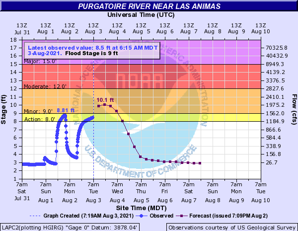
On the eastern side of the state, the Purgatoire River near Las Animas is in an “Action Stage” this morning, as seen in the hydrograph below. Flows along the Arkansas River have returned to below flood or action stage, but many are still above normal for this time of year.
For rainfall estimates in your area, including antecedent conditions, check out the State Precipitation Map below.
Click Here For Map Overview

The map below shows radar-estimated, rainfall gage-adjusted Quantitative Precipitation Estimates (QPE) across Colorado. The map is updated daily during the operational season (May 1 – Sep 30) by 11AM. The following six layers are currently available: 24-hour, 48-hour and 72-hour total precipitation, as well as maximum 1-hour, 2-hour and 6-hour precipitation over the past 24 hour period (to estimate where flash flooding may have occurred). The accumulation ending time is 7AM of the date shown in the bottom right corner. Also shown optionally are vulnerable fire burn areas (post 2012), which are updated throughout the season to include new, vulnerable burn areas. The home button in the top left corner resets the map to the original zoom.

SPM 08-02-2021: High Flows on Arkansas River, Monsoonal Moisture Plume Moves Westward

Issue Date: Monday, August 2nd, 2021
Issue Time: 9:00 AM MDT

Summary:

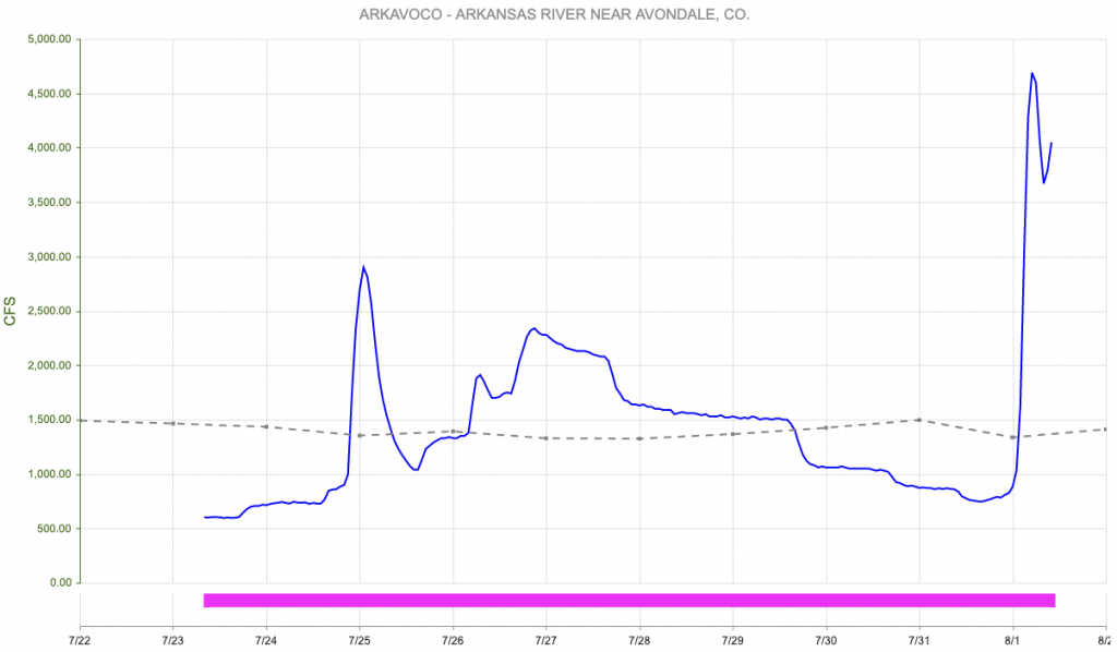
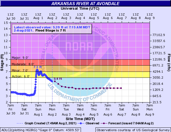
The month of August kicked off with some lingering early morning showers in the Southeast Mountains and Raton Ridge, which dissipated in the late morning. By early afternoon, a flash flood warning was issued for the Arkansas River in response to the showers and the heavy rain on Saturday. The Arkansas River at Avondale briefly reached minor flood stage early Sunday morning, when the river stage peaked at 7.3 feet. The river remained high and in an “Action Stage” for most of Sunday, as seen in the hydrograph below. As of this morning, flows all along the Arkansas River and Purgatoire River, a tributary to the Arkansas, are still above normal for this time of year.

Storms dissipated in the Southeast Mountains just as monsoonal storms started to fire off in the Western Slope and Grand Valley, thanks to the plume of monsoonal moisture moving west of Divide. Rainfall totals were not nearly as impressive as storms on Saturday, but several areas received significant rainfall. A CoCoRaHS observer in Hotchkiss in Delta County reported up to 0.86 inches of rain yesterday. The elevated monsoonal moisture in the Northern and Central Mountains provided favorable conditions for firefighting. The Morgan Creek fire benefited from the higher humidity and slow moving storms, which limited fire weather. For estimates of precipitation in your area, please check our State Precipitation Map at the bottom of today’s post.

Flooding was reported on Douglas Pass in the Northwest Slope last night on the Pine Gulch burn scar. Law Enforcement reported water and mud running over Highway 139 due to heavy runoff from the East Salt Creek. Due to the very rural location of this region, there are limited rainfall observations, but a BLM gauge roughly 15 miles northeast of Douglas Pass reported 0.41 inches of rain – all within a 3-hour period.

While no heavy rain or flooding was actually reported on the Grizzly Creek burn scar yesterday, I-70 remains closed due to flash flooding and debris flows in Glenwood Canyon on Saturday. CDOT shared the following pictures on Twitter yesterday, showing the extensive damage to the interstate.

Elsewhere, along the Urban Corridor and Eastern Plains, a cold frontal passage from the north acted to drop temperatures for the day and limited precipitation, but with it came reduced air quality as smoke from fires in the Western US and Canada was advected south into Colorado.

Click Here For Map Overview

The map below shows radar-estimated, rainfall gage-adjusted Quantitative Precipitation Estimates (QPE) across Colorado. The map is updated daily during the operational season (May 1 – Sep 30) by 11AM. The following six layers are currently available: 24-hour, 48-hour and 72-hour total precipitation, as well as maximum 1-hour, 2-hour and 6-hour precipitation over the past 24 hour period (to estimate where flash flooding may have occurred). The accumulation ending time is 7AM of the date shown in the bottom right corner. Also shown optionally are vulnerable fire burn areas (post 2012), which are updated throughout the season to include new, vulnerable burn areas. The home button in the top left corner resets the map to the original zoom.

SPM 08-01-2021: Torrential Rain Across Southeast Colorado; Heavy Rain Over Western Slope As Well

Issue Date: Sunday, August 1st, 2021
Issue Time: 11AM MDT

Summary:

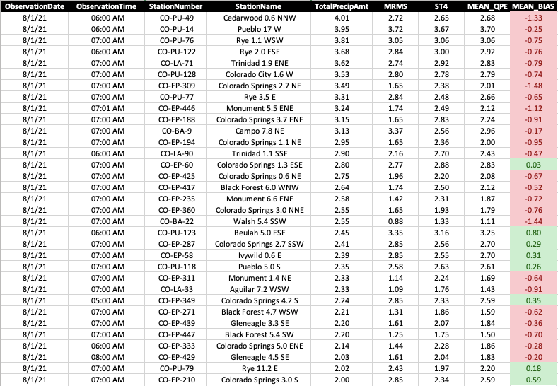
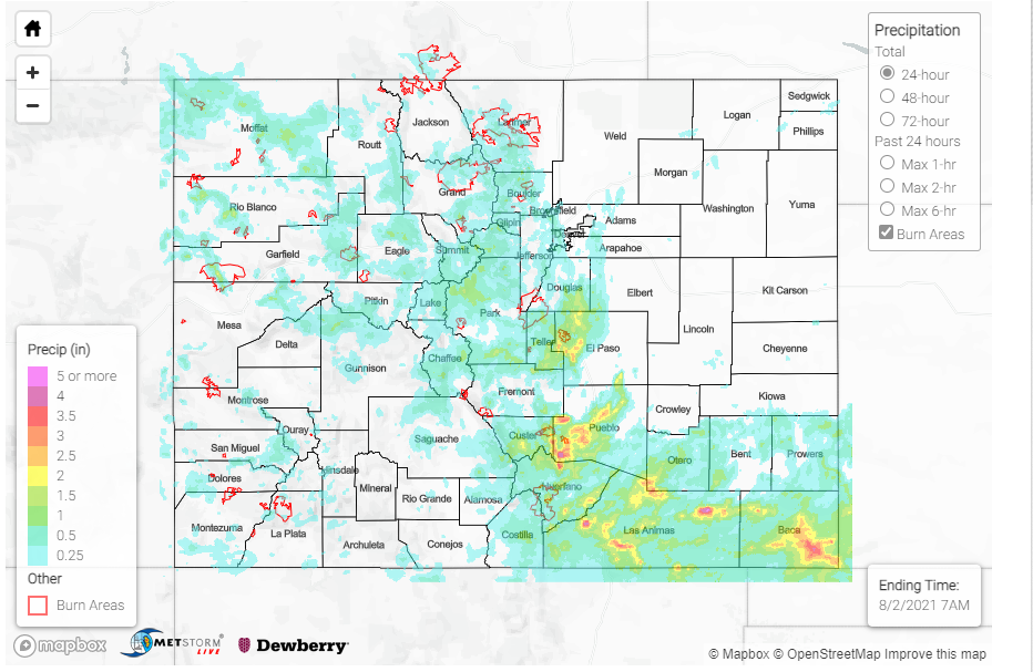
The long awaited intense rainfall event finally came and went on Saturday, and generally speaking, lived up to its expectations. By far the most intense rainfall occurred over southeast Colorado, generally along the I-25 corridor south of Colorado Springs and eastward, along and south of the Arkansas River. Extremely efficient tropical-style rainfall from copious moisture overcame a lack of instability to provide widespread areas with at least 2 inches of rainfall. However, isolated pockets received more than that. Much more. The highest reliable observation came in from near Pueblo with 5.03 inches! A CoCoRaHS observer east of Colorado City (between Pueblo and Walsenburg) reported 4.01 inches. Numerous other reports in the 3-4 inch range also came in from El Paso, Las Animas, Baca and Pueblo counties. As of 10:30AM, eleven reports showed above 3 inches of rain. The highest estimated rainfall was from Baca County where up to 7 inches is shown! However, that area is one of the more difficult parts of the state to estimate because radar beams from various NWS radars measure storms very high above the ground, often leading to overestimates. On the other hand, yesterday’s warm coalescence rainfall actually led to the underestimate of almost all high-end rainfall amounts. See the table below showing that 25 of the highest 33 CoCoRaHS reports were underestimated by our gridded products, some significantly. So, 7 inches is certainly not out of the question.

In terms of the hydrologic response, numerous flood reports came in from southeast Colorado. In Baca County, where the highest rainfall in the state probably occurred, a report of 3 feet of water overtopping a road was received from east of Campo. Vehicles were reported stranded in flood water near Colorado Springs. Many reports of flooded roads came in from Pueblo. A long stretch of washed out road was reported south of Walsenburg just west of I-25. In all, runoff trickled into the Fountain Creek, Saint Charles River, Hardscrabble Creek, Huerfano River among other smaller creeks and tributaries to cause a flood wave on the Arkansas River that went from about 600 cfs to over 4,500 cfs in a matter of hours (see below). It is possible that even higher flows will occur downstream in the coming hours as additional sub-basins downstream chip in their share.

Along and west of the Continental Divide, numerous reports of heavy rainfall above 1 inch were received from Rio Blanco, Garfield and Gunnison counties. At least two reports of debris slides and mud flows were received as of this morning. One, from Poncha Pass where Highway 285 was blocked. Another from just outside of Telluride where a “large” mudflow forced the closure of Highway 145.

Finally, it was another active day for fire burn areas across the state. Possibly for the first day thus far, all six fire burns were under a Flash Flood Warning at some point on Saturday afternoon. The most severe outcomes were likely over the Spring Creek and Pine Gulch burns. Over Spring Creek, at least 1.5 inches of rain fell resulting in Highway 421 being overtopped for “hundreds of yards”. Meanwhile, over Pine Gulch, storm chaser Reed Timmer filmed an impressive mud flow on its northeast side. A stone’s throw away on the southwest side of the burn, addition mud flows resulted in evacuation orders for downstream neighborhoods.

In short, the monsoon of 2021 rages on.

For estimates of precipitation in your area, please check our State Precipitation Map below.

Click Here For Map Overview

The map below shows radar-estimated, rainfall gage-adjusted Quantitative Precipitation Estimates (QPE) across Colorado. The map is updated daily during the operational season (May 1 – Sep 30) by 11AM. The following six layers are currently available: 24-hour, 48-hour and 72-hour total precipitation, as well as maximum 1-hour, 2-hour and 6-hour precipitation over the past 24 hour period (to estimate where flash flooding may have occurred). The accumulation ending time is 7AM of the date shown in the bottom right corner. Also shown optionally are vulnerable fire burn areas (post 2012), which are updated throughout the season to include new, vulnerable burn areas. The home button in the top left corner resets the map to the original zoom.

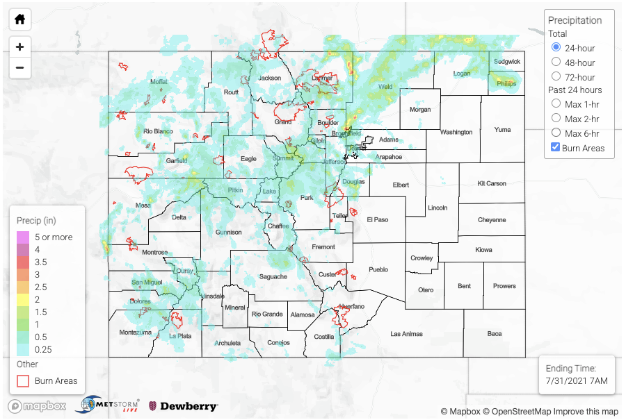
SPM 07-31-2021: Higher Terrain Storms Finally Spill Over Into Foothills And Plains

Issue Date: Saturday, July 31st, 2021
Issue Time: 11:15AM MDT

Summary:

The relentless monsoon season continued on Friday with storms dumping heavy rainfall across most of the higher terrain as well as the foothills. However, one major difference, compared to previous days, was that storms finally held intact while moving eastward into the plains. In fact, some of the most impressive storms totals occurred over the lower elevations. The most intense rainfall over the state occurred over the northern portion of the Denver metro area where 3.56 inches were recorded by a CoCoRaHS observer just north of Broomfield. An inspection of the distribution showed that two storm complexes moved across that area, with each dumping roughly 1-1.5 inches per hour. A disturbing flood report was received in that area noting that people had to be rescued from a vehicle trapped in flood water. Fortunately, the area of heavy rainfall was limited enough to suppress any major riverine response.

West of the Continental Divide, heavy rainfall once again fell. The most impressive storm complex occurred over the Elk Mountains and extended to the Grand Mesa. Redstone received 1.50 inches, from a CoCoRaHS report along with small hail. The peach capital of Colorado, Palisade received 1.38 inches, also from a CoCoRaHS report. Highway 133 was closed due to multiple mud flows between mile markers 54 and 58. A couple of severe thunderstorm warnings were also issued, for damaging winds.

Moving on to the fire burn overview, the Cameron Peak and East Troublesome burn scars received flash flood warnings on Friday. The more severe situation was definitely over the Cameron Peak burn, where multiple mud flows and debris slides were reported. Furthermore, Buckhorn Creek experienced a flood wave that overtopped into the road. Up 1.5-2.5 inches fell over the burn area, which is easily enough to trigger mud flows along with the normal excessive runoff. Debris slides and mud flows were also reported along CO 14 on the northern side of the fire burn. Isolated moderate to possibly heavy rainfall also fell over the East Troublesome fire burn with a report of debris slides and mud flows report over Highway 125 at 4:30PM. Lastly, I-70 remained close in the vicinity of the Grizzly Creek burn scar, due to a combination of the elevated flood threat as well as ongoing debris cleanup work.

For estimates of precipitation in your area, please check our State Precipitation Map below.

Click Here For Map Overview

The map below shows radar-estimated, rainfall gage-adjusted Quantitative Precipitation Estimates (QPE) across Colorado. The map is updated daily during the operational season (May 1 – Sep 30) by 11AM. The following six layers are currently available: 24-hour, 48-hour and 72-hour total precipitation, as well as maximum 1-hour, 2-hour and 6-hour precipitation over the past 24 hour period (to estimate where flash flooding may have occurred). The accumulation ending time is 7AM of the date shown in the bottom right corner. Also shown optionally are vulnerable fire burn areas (post 2012), which are updated throughout the season to include new, vulnerable burn areas. The home button in the top left corner resets the map to the original zoom.