Issue Date: Saturday, July 31st, 2021
Issue Time: 11:15AM MDT
Summary:
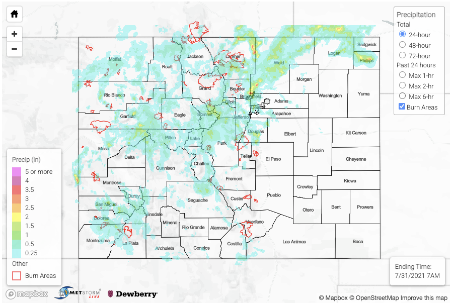
The relentless monsoon season continued on Friday with storms dumping heavy rainfall across most of the higher terrain as well as the foothills. However, one major difference, compared to previous days, was that storms finally held intact while moving eastward into the plains. In fact, some of the most impressive storms totals occurred over the lower elevations. The most intense rainfall over the state occurred over the northern portion of the Denver metro area where 3.56 inches were recorded by a CoCoRaHS observer just north of Broomfield. An inspection of the distribution showed that two storm complexes moved across that area, with each dumping roughly 1-1.5 inches per hour. A disturbing flood report was received in that area noting that people had to be rescued from a vehicle trapped in flood water. Fortunately, the area of heavy rainfall was limited enough to suppress any major riverine response.
West of the Continental Divide, heavy rainfall once again fell. The most impressive storm complex occurred over the Elk Mountains and extended to the Grand Mesa. Redstone received 1.50 inches, from a CoCoRaHS report along with small hail. The peach capital of Colorado, Palisade received 1.38 inches, also from a CoCoRaHS report. Highway 133 was closed due to multiple mud flows between mile markers 54 and 58. A couple of severe thunderstorm warnings were also issued, for damaging winds.
Moving on to the fire burn overview, the Cameron Peak and East Troublesome burn scars received flash flood warnings on Friday. The more severe situation was definitely over the Cameron Peak burn, where multiple mud flows and debris slides were reported. Furthermore, Buckhorn Creek experienced a flood wave that overtopped into the road. Up 1.5-2.5 inches fell over the burn area, which is easily enough to trigger mud flows along with the normal excessive runoff. Debris slides and mud flows were also reported along CO 14 on the northern side of the fire burn. Isolated moderate to possibly heavy rainfall also fell over the East Troublesome fire burn with a report of debris slides and mud flows report over Highway 125 at 4:30PM. Lastly, I-70 remained close in the vicinity of the Grizzly Creek burn scar, due to a combination of the elevated flood threat as well as ongoing debris cleanup work.
For estimates of precipitation in your area, please check our State Precipitation Map below.
