Issue Date: Tuesday, August 3rd, 2021
Issue Time: 9:15 AM MDT
Summary:
Another day of ample monsoonal moisture brought several rounds of widespread thunderstorm coverage to the western half of the state yesterday, amplified by the west-east passage of an upper-level trough imbedded in the moisture plume. Storms kicked off early along the Colorado-Utah border in the Grand Valley and Southwest Slope with a general eastward movement before dissipating in the late morning. By early afternoon, thunderstorms had developed again – warranting flood advisories and warnings to be issued across the Northern, Central, and Southeast Mountains, as well as the Grand Valley and Southwest Slope. Many of the major burn scars in Colorado had flood warnings issued, including the Cameron Peak, East Troublesome, William’s Fork, Grizzly Peak, Decker, and Pine Gulch fires after radar indicated heavy rainfall potential.
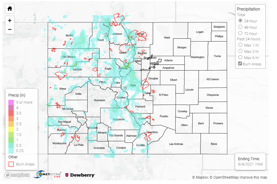
Flooding was reported on the Spring Creek burn scar in the Southeast Mountains. Highway 12 was reported to be overtopped with water, though no debris. This was after two flash flood warnings were issued for both the northern and southern portions of the burn scar. Rainfall totals yesterday on the burn scar were not particularly impressive, around 0.10 inches. However, the MetStorm live grids in today’s State Precipitation Map (below) suggest this region has received between 0.50 and 2.00 inches in the last 72-hours.
County Roads 107 and 107A were flooded in Salida, nearby the Decker fire burn scar. Between 0.11-0.24 inches of rain was reported between MesoWest and CoCoRaHS observations. This is another instance of not particularly high single day rain, but the culmination of several days of we weather.
Two additional flood reports came in from Crestone, CO. Scouring of gravel roads by flood waters resulted in deep trenches in some of the ditches, and a typically dry arroyo was filled to the banks. A CoCoRaHS observer in Crestone reported up to 1.35 inches of rain yesterday!
The Pine Gulch burn scar also likely had an overnight debris flow. Reed Timmer shared the following radar image of heavy rain, as well as an estimated line of the debris flow advancement. This burn scar is very rural in nature, so there are limited observations to verify this report. Gridded MetStorm precipitation estimates show between 0.25-0.50 on the northeast portion of the burn scar. Remember, if you observe flooding in your area you can utilize the “Report a Flood” tab when you are safe to do so.
NOCTURNAL DEBRIS FLOW likely maturing now along the Roan Creek drainage (estimated by white line) off the Pine Gulf fire burn scar. I know there are some homes along that creek that experienced a debris plug estimated at 20 feet high during a recent flood. #cowx #monsoon2021 pic.twitter.com/SzGHZr278b
— Reed Timmer (@ReedTimmerAccu) August 3, 2021
Some other notable rainfall totals from CoCoRaHS observers across the state include:
- 1.09 inches in Glade Park, southwest of Grand Junction
- 0.80 inches in both Silverthorne and Frisco
- 0.70 inches in Buena Vista
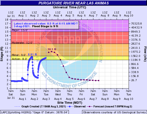
On the eastern side of the state, the Purgatoire River near Las Animas is in an “Action Stage” this morning, as seen in the hydrograph below. Flows along the Arkansas River have returned to below flood or action stage, but many are still above normal for this time of year.
For rainfall estimates in your area, including antecedent conditions, check out the State Precipitation Map below.
