Issue Date: Monday, August 2nd, 2021
Issue Time: 9:00 AM MDT
Summary:
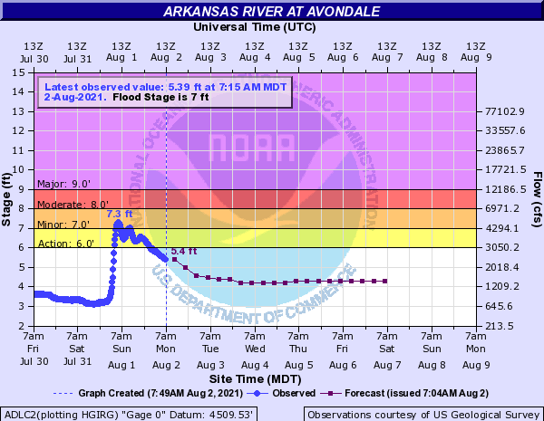
The month of August kicked off with some lingering early morning showers in the Southeast Mountains and Raton Ridge, which dissipated in the late morning. By early afternoon, a flash flood warning was issued for the Arkansas River in response to the showers and the heavy rain on Saturday. The Arkansas River at Avondale briefly reached minor flood stage early Sunday morning, when the river stage peaked at 7.3 feet. The river remained high and in an “Action Stage” for most of Sunday, as seen in the hydrograph below. As of this morning, flows all along the Arkansas River and Purgatoire River, a tributary to the Arkansas, are still above normal for this time of year.
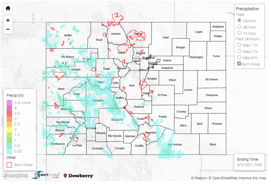
Storms dissipated in the Southeast Mountains just as monsoonal storms started to fire off in the Western Slope and Grand Valley, thanks to the plume of monsoonal moisture moving west of Divide. Rainfall totals were not nearly as impressive as storms on Saturday, but several areas received significant rainfall. A CoCoRaHS observer in Hotchkiss in Delta County reported up to 0.86 inches of rain yesterday. The elevated monsoonal moisture in the Northern and Central Mountains provided favorable conditions for firefighting. The Morgan Creek fire benefited from the higher humidity and slow moving storms, which limited fire weather. For estimates of precipitation in your area, please check our State Precipitation Map at the bottom of today’s post.
Flooding was reported on Douglas Pass in the Northwest Slope last night on the Pine Gulch burn scar. Law Enforcement reported water and mud running over Highway 139 due to heavy runoff from the East Salt Creek. Due to the very rural location of this region, there are limited rainfall observations, but a BLM gauge roughly 15 miles northeast of Douglas Pass reported 0.41 inches of rain – all within a 3-hour period.
While no heavy rain or flooding was actually reported on the Grizzly Creek burn scar yesterday, I-70 remains closed due to flash flooding and debris flows in Glenwood Canyon on Saturday. CDOT shared the following pictures on Twitter yesterday, showing the extensive damage to the interstate.
(8/1) I-70 through Glenwood Canyon will continue to be closed due to extreme damage from the latest round of flooding Saturday night (7/31). Motorists advised to take northern alternate route (see map), and trucks traveling through take I-80. Go to https://t.co/bjBVfjLWOG. pic.twitter.com/LOJIV0rvh6
— Colorado Department of Transportation (CDOT) (@ColoradoDOT) August 1, 2021
Elsewhere, along the Urban Corridor and Eastern Plains, a cold frontal passage from the north acted to drop temperatures for the day and limited precipitation, but with it came reduced air quality as smoke from fires in the Western US and Canada was advected south into Colorado.

