SPM 05-06-2022: Calm and Clear Day Across State

Issue Date: Friday, May 5th, 2022
Issue Time: 9:40 AM MDT

Summary:

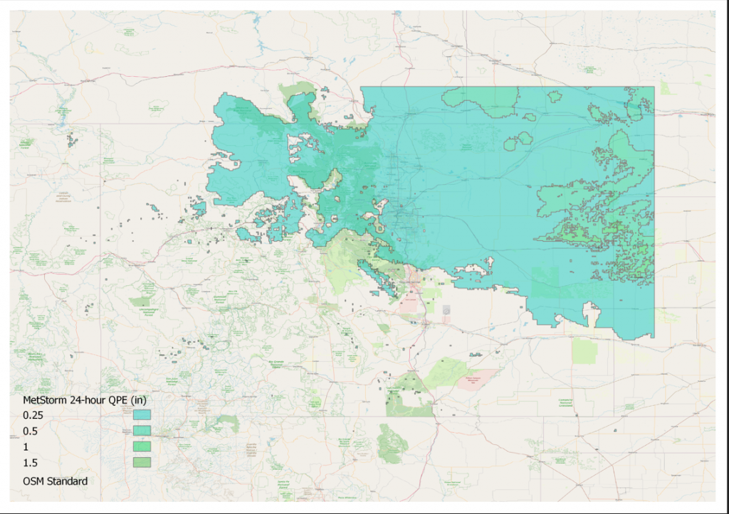
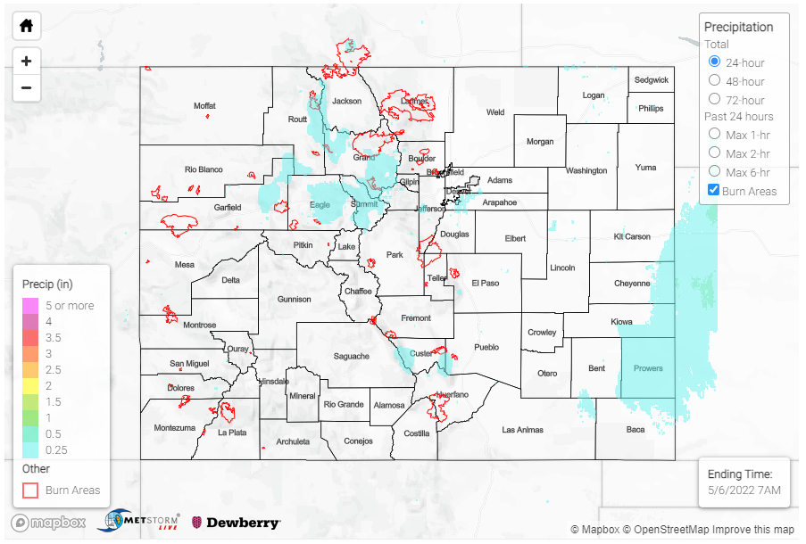
As expected, yesterday saw clear skies and beautiful weather across the state. There were some lingering early morning showers along the tail-end of a line of storms extending from Eastern Colorado through Central Nebraska. Precipitation totals were very light – less than 0.10 inches of rain, though the MetStorm QPE in the map below indicates higher totals. CoCoRaHS observers in Cheyenne County reported between just Trace – 0.07 inches of rain.

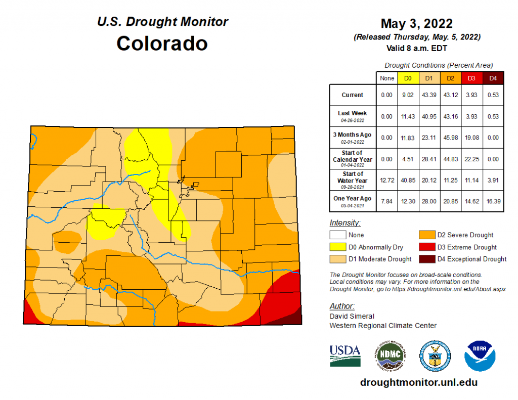
The most recent U.S. Drought Monitor Statistics released yesterday (shown below) indicate little change between last week, though any additional rainfall from Tuesday-Thursday is not included in this update.  Over 80% of Colorado is still experiencing between Moderate (D1) to Severe (D2) Drought. We won’t see until next week’s update how the wet start of the month has really impacted drought conditions.

There were no flood reports yesterday. For rainfall estimates in your area, check out the MetStorm Live QPE below.
Click Here For Map Overview

The map below shows radar-estimated, rainfall gage-adjusted Quantitative Precipitation Estimates (QPE) across Colorado. The map is updated daily during the operational season (May 1 – Sep 30) by 11AM. The following six layers are currently available: 24-hour, 48-hour and 72-hour total precipitation, as well as maximum 1-hour, 2-hour and 6-hour precipitation over the past 24 hour period (to estimate where flash flooding may have occurred). The accumulation ending time is 7AM of the date shown in the bottom right corner. Also shown optionally are vulnerable fire burn areas (post 2012), which are updated throughout the season to include new, vulnerable burn areas. The home button in the top left corner resets the map to the original zoom.

SPM 05-05-2022: Heavy Rain in Southern and Eastern Colorado

Issue Date: Thursday, May 5th, 2022
Issue Time: 11:20 AM MDT

Summary:

It was finally a portion of Southern Colorado’s turn for a bit of wild weather and accumulating precipitation yesterday – thanks to the quick moving low-pressure system traversing the state, as mentioned in yesterday’s FTB (and Monday’s FTO).

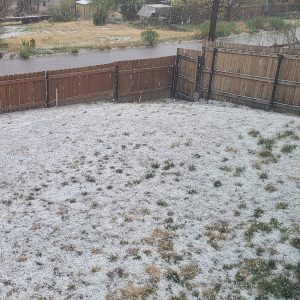
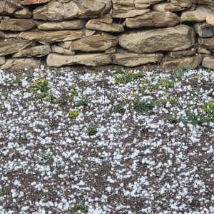
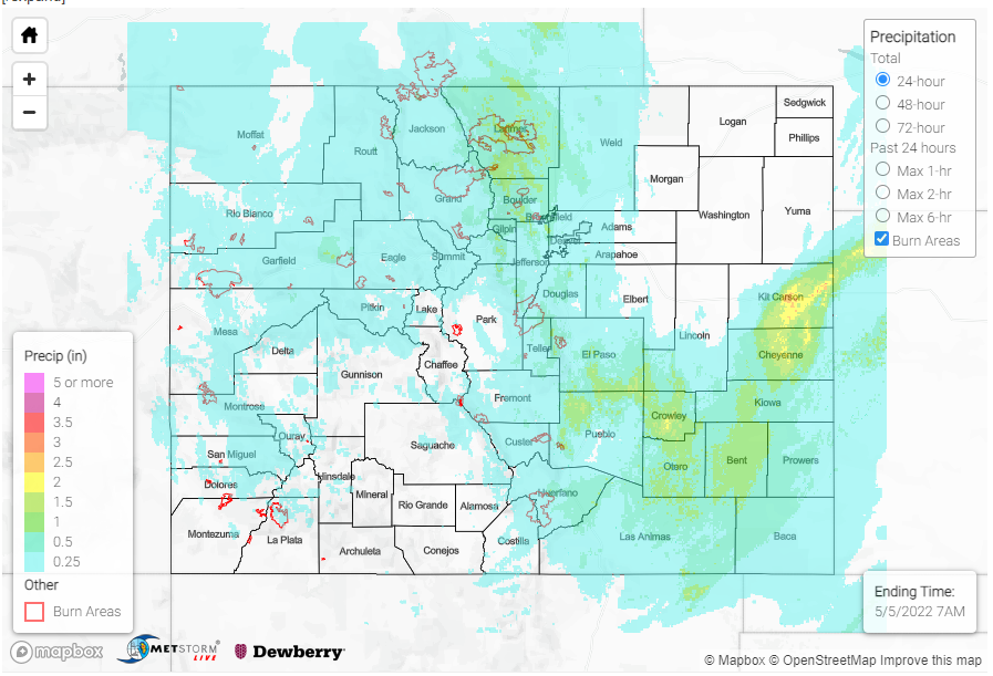
A NWS employee in Pueblo reported heavy rain at 10:30 pm last night, indicating that up to 1.14 inches of rain had fallen so far. CoCoRaHS observations around town confirm this, with up to 1.29 inches of precipitation reported in 24-hours, which included lots of pea-sized to dime-sized hail. A bit further south, a severe thunderstorm warning was issued for a cell northwest of Trinidad for a cell producing 60 mph winds and up to quarter size hail. At my house in Trinidad, we had enough pea-sized hail to accumulate like snow!

Overnight, training heavy rain prompted a flood warning for Kit Carson County in the Northeast Plains, with impacts to I-70 and the towns of Burlington and Bethune. A CoCoRaHS observer reported 1.37 inches of precipitation in Burlington, with similar totals from a few more observers in town. The flood warning was able to expire this morning, with no known flood reports so far. If you happened to observe flooding in this area, or elsewhere, remember to use our “Report a Flood” tool.

Elsewhere in the state, it was another day of good soaking rain for the Urban Corridor and snow for the Front Range, Northern, and Central Mountains. Traffic cams on I-70 show snowy conditions this morning and CDOT is reporting many icy and snowpacked roads. Out west, there were only modest precipitation totals on the Western Slopes and in the Grand Valley, since the low had moved eastward early in the morning.

There were no flood reports yesterday. For rainfall estimates in your area, check out the MetStorm Live QPE below.
Click Here For Map Overview

The map below shows radar-estimated, rainfall gage-adjusted Quantitative Precipitation Estimates (QPE) across Colorado. The map is updated daily during the operational season (May 1 – Sep 30) by 11AM. The following six layers are currently available: 24-hour, 48-hour and 72-hour total precipitation, as well as maximum 1-hour, 2-hour and 6-hour precipitation over the past 24 hour period (to estimate where flash flooding may have occurred). The accumulation ending time is 7AM of the date shown in the bottom right corner. Also shown optionally are vulnerable fire burn areas (post 2012), which are updated throughout the season to include new, vulnerable burn areas. The home button in the top left corner resets the map to the original zoom.

SPM 05-04-2022: Mountain Rain and Snow; Late Night Rain for Urban Corridor

Issue Date: Wednesday, May 4th, 2022
Issue Time: 10:00 AM MDT

Summary:

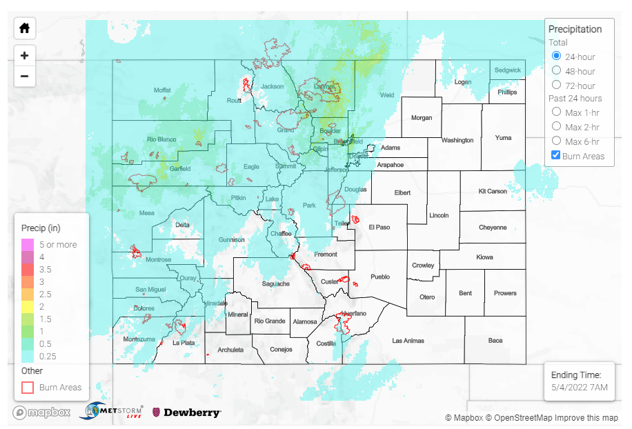
Another low-pressure system entered the state yesterday from the west, bringing widespread precipitation for Western and Northern Colorado by the afternoon. For the high elevations, this brought a wintry mix of rain and snow; and by late evening the eastward progression brought showers to the Urban Corridor, with some lingering sprinkles well into this morning.

Starting from west to east, CoCoRaHS observers in the Grand Valley and Northwest Slope reported up to 0.82 inches of precipitation in Palisade (Mesa County) and 0.69 in Rangely (Rio Blanco County). In Grand Junction, precipitation totals range from 0.10-0.30 across town, with similar magnitude values along the I-70 corridor moving eastward. In addition to showers, much of western Colorado experienced high winds yesterday – a 65 mph non-thunderstorm gust was reported in Hotchkiss (Delta County).

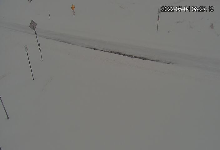
An estimated 8 inches of snow was reported at Never Summer SNOTEL in Gould, and 7 inches at the Willow Park SNOTEL near Cameron Pass, both in Larimer County. Across the Northern and Central mountains, SNOTEL stations picked up between 1-4 inches of snow. CDOT has also issued a safety closure for US6 between I-70 and Loveland pass from the snow, and the Live View webcam shows snowpacked road conditions this morning.

US-6, Loveland Pass looking west at 8:27 am (Courtesy of CDOT)

Ashton Altieri of CBS4 also shared the following image of snow in Winter Park this morning!

Moving to the Front Range Mountains, some notable totals include a CoCoRaHS observer in Nederland (Boulder County) that reported 0.97 inches of precipitation with 2.8 inches of snow starting about 8pm, mixed with some freezing rain, and 0.78 inches was reported in Drake (Larimer County). For the Urban Corridor, highest precipitation totals fell up against the foothills and western edge of the Denver Metro Area.  Between 0.4-0.7 inches of precipitation was reported across Fort Collins between CoCoRaHS observers and the city’s gauge network. Similarly, 0.25-0.5 was reported across the Northwest Denver Suburbs out to Boulder, with totals decreasing to the southeast. For example, 0.28 was reported at a MHFD gauge in Arvada compared to 0.04 in Parker.

Conditions remained generally dry for Southern Colorado, with smoke in the air from the explosive Cooks Peak and Hermits Peak fires in northern New Mexico, accompanied by their own Red Flag warnings.

There were no flood reports yesterday. For rainfall estimates in your area, check out the MetStorm Live QPE below.
Click Here For Map Overview

The map below shows radar-estimated, rainfall gage-adjusted Quantitative Precipitation Estimates (QPE) across Colorado. The map is updated daily during the operational season (May 1 – Sep 30) by 11AM. The following six layers are currently available: 24-hour, 48-hour and 72-hour total precipitation, as well as maximum 1-hour, 2-hour and 6-hour precipitation over the past 24 hour period (to estimate where flash flooding may have occurred). The accumulation ending time is 7AM of the date shown in the bottom right corner. Also shown optionally are vulnerable fire burn areas (post 2012), which are updated throughout the season to include new, vulnerable burn areas. The home button in the top left corner resets the map to the original zoom.

SPM 05-03-2022: Soaking Rain and Even Snow for Northern and Eastern Colorado

Issue Date: Tuesday, May 3rd, 2022
Issue Time: 10:10 AM MDT

Summary:

The low-pressure system and associated cold front impacting the state’s weather over the last few days continued its eastward progression yesterday. This allowed for morning rain, and even snow, for much of the northeast quadrant of the state. As the day progressed, a general drying trend from west to east followed the exiting system, with precipitation largely ending by late afternoon. Available moisture at the surface from a few days of precipitation and cooler temperatures allowed for fog formation overnight, which has lingered into this morning for the Northeast Plains, Palmer Ridge, and Urban Corridor.

Precipitation totals from yesterday are most impressive in the Northeast Plains, including 1.57 inches from a CoCoRaHS observer in Wray (Yuma County), who also noted  “Nice rain turning to snow about 10:30am. Snow melted about 4pm. Heavy frost and fog overnight.1.25 inches was reported in Sterling (Logan County) and 0.96 in Burlington (Kit Carson County).

Precipitation totals were more modest to the west along the Urban Corridor and Front Range Mountains. QPE, as seen in the map below, has precipitation totals around 0.25 inches; however, CoCoRaHS and other local gauge networks reports generally range between only 0.0-0.15 inches across the Urban Corridor, with values approaching 0.25 on the eastern edge of the Front Range Mountains.

There were no flood reports yesterday. For rainfall estimates in your area, check out the MetStorm Live QPE below.
Click Here For Map Overview

The map below shows radar-estimated, rainfall gage-adjusted Quantitative Precipitation Estimates (QPE) across Colorado. The map is updated daily during the operational season (May 1 – Sep 30) by 11AM. The following six layers are currently available: 24-hour, 48-hour and 72-hour total precipitation, as well as maximum 1-hour, 2-hour and 6-hour precipitation over the past 24 hour period (to estimate where flash flooding may have occurred). The accumulation ending time is 7AM of the date shown in the bottom right corner. Also shown optionally are vulnerable fire burn areas (post 2012), which are updated throughout the season to include new, vulnerable burn areas. The home button in the top left corner resets the map to the original zoom.