SPM 06-07-2022: More Hail and Heavy Rain

Issue Date: Tuesday, June 7th, 2022
Issue Time: 11:15 AM MDT

Summary:

Active weather continued across the state on Monday as another shortwave trough moving across the Intermountain West and Northern Rockies produced showers and storms over Colorado, including more severe weather. Convection developed yesterday afternoon over the high terrain along the Divide, before pushing off eastward into the adjacent plains where better moisture and instability was encountered.

Precipitation amounts along the Urban Corridor were generally T-0.25”, with locally higher amounts of 0.25”-0.75” in the vicinity of Fort Collins and Colorado Springs. Storms over the Northern Mountains and northern Front Range prompted the Boulder WFO to issue Flood Advisories for both Grand and Larimer Counties, including the Cameron Peak and East Troublesome burn scars. The advisories were issued for minor flooding of small streams and low-lying/poor drainage areas; a station near Grand Lake measured just under 0.50” of rainfall in approximately 90 minutes. Thanks to fast flow aloft and storm motions of 35+ mph, no flooding was reported across either burn scar.

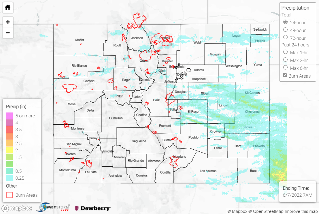
The heaviest precipitation yesterday occurred in a swath from the southern Urban Corridor across the Palmer Ridge and into the Southeast Plains. Healthy rainfall amounts of 0.50-1.50”, with locally higher amounts, were widespread across this corridor. Some noteworthy observations include:

• 1.71” 3 miles SW of Lamar
• 1.14” 1 mile NE of Peyton
• 0.92” at Lamar Municipal Airport
• 0.86” 3 miles NNE of Cheyenne Wells

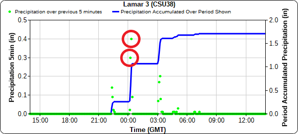
The town of Lamar was particularly hard hit, with 1.75” hail and an 82-mph thunderstorm wind gust recorded at Lamar Municipal Airport. The Pueblo WFO issued a Flash Flood Warning for west-central Prowers County including Lamar after local law enforcement reported “widespread flooded roads and other minor flooding.” An automated station 3 miles SW of Lamar reported 0.30” and 0.40” of rainfall in consecutive 5-minute periods, which translates to 0.70” in just 10 minutes!

In total, there were 16 hail reports within the patchwork of Severe Thunderstorm Warnings that blanketed the Southeast Plains yesterday. The severe weather threat waned by late evening, save for extreme southeastern Colorado. West of the Divide remained mainly dry, with only a trace to couple hundredths of an inch of rain reported, although several non-thunderstorm wind gusts approaching 50 mph were reported near Grand Junction and Glenwood Springs.

The only flooding reported statewide yesterday was in Lamar. For precipitation estimates in your area, check out the map below.
Click Here For Map Overview

The map below shows radar-estimated, rainfall gage-adjusted Quantitative Precipitation Estimates (QPE) across Colorado. The map is updated daily during the operational season (May 1 – Sep 30) by 11AM. The following six layers are currently available: 24-hour, 48-hour and 72-hour total precipitation, as well as maximum 1-hour, 2-hour and 6-hour precipitation over the past 24 hour period (to estimate where flash flooding may have occurred). The accumulation ending time is 7AM of the date shown in the bottom right corner. Also shown optionally are vulnerable fire burn areas (post 2012), which are updated throughout the season to include new, vulnerable burn areas. The home button in the top left corner resets the map to the original zoom.

SPM 06-06-2022: High-Based Showers and Storms, More Severe Weather

Issue Date: Monday, June 6th, 2022
Issue Time: 11:30 AM MDT

Summary:

Sunday saw high-based showers and thunderstorms as an upper-level shortwave moved across the state. Precipitation was mainly confined to along and north of I-70, save for an isolated low-precipitation supercell that developed mid-afternoon in Kit Carson County and tracked south-southeastward. Severe weather was confined to the easternmost tier of Colorado counties, with hail being the predominant hazard reported yesterday. The aforementioned supercell lasted for several hours and produced hail up to 2” diameter as well as a 63-mph thunderstorm wind gust near Lamar; the storm prompted eight severe thunderstorm warnings as well as one tornado warning north of Lamar, although no tornadoes were reported. The only other severe weather reported yesterday was a thunderstorm wind gust of 54 mph in the northeast corner of the state near Julesburg. Check out these photos of the supercell from a storm chaser as it neared the town of Walsh:

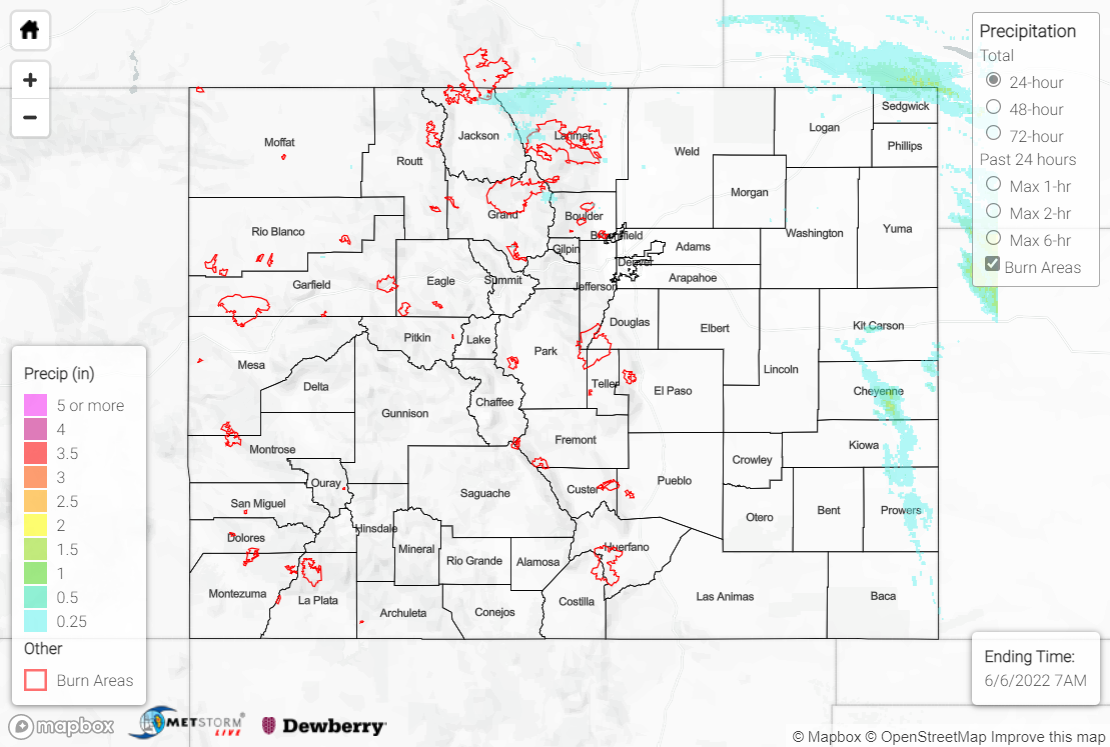
As far as precipitation goes, rainfall amounts were generally light with T-0.25” reported by observers across the Northern Mountains, Front Range, and Urban Corridor. CoCoRaHS observers in northern Sedgwick County reported over 0.50” of rainfall, with a maximum of 0.61” in Julesburg. The other swath of noteworthy precipitation across the state was associated with the low-precipitation supercell, stretching from Kit Carson County southward into northeastern Baca County. Rainfall observations are sparse, but a MesoWest station near Lamar reported 0.36” of rainfall. Remotely-sensed QPE indicates a narrow swath of 0.50-1.50”, although these amounts might be biased upwards; the presence of large hail within a storm can lead to incorrect rainfall estimates, and this storm had twelve confirmed hail reports, one of which explicitly noted the lack of rain falling.

There was no flooding reported yesterday. For precipitation estimates in your area, check out the map below.
Click Here For Map Overview


The map below shows radar-estimated, rainfall gage-adjusted Quantitative Precipitation Estimates (QPE) across Colorado. The map is updated daily during the operational season (May 1 – Sep 30) by 11AM. The following six layers are currently available: 24-hour, 48-hour and 72-hour total precipitation, as well as maximum 1-hour, 2-hour and 6-hour precipitation over the past 24 hour period (to estimate where flash flooding may have occurred). The accumulation ending time is 7AM of the date shown in the bottom right corner. Also shown optionally are vulnerable fire burn areas (post 2012), which are updated throughout the season to include new, vulnerable burn areas. The home button in the top left corner resets the map to the original zoom.

SPM 06-05-2022: Another Round of Thunderstorms for Northeast Plains

Issue Date: Sunday, June 5th, 2022
Issue Time: 10:40 AM MDT

Summary:

Saturday was much less eventful compared to the active severe weather day seen on Friday for the state. Still, isolated showers and thunderstorms began to form along the Northern Mountains and Front Range in the early afternoon from daytime heating, before progressing eastward off the mountains and onto the Urban Corridor, Palmer Ridge and Northeast Plains as the day continued. Residual outflow boundaries from storms the day before allowed for numerous thunderstorms, some severe, to develop on the Northeast Plains, mainly along the I-76 and I-70 corridors.

The main threats from severe thunderstorms were high winds and damaging hail, rather than heavy rainfall. Both a funnel cloud and landspout were reported in rural Kit Carson and Yuma counties, respectively; but most of the severe action remained on the Kansas side of the border.
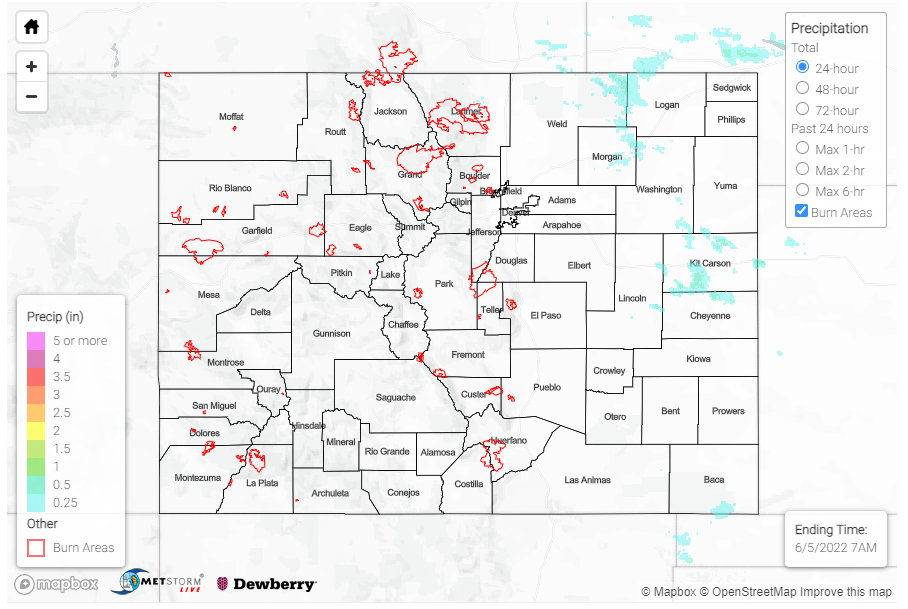
Just 0.15 inches from storms was reported by a CoCoRaHS observer in Burlington, and Fort Morgan saw the highest precipitation observation of the day from an observer who reported 0.26 inches. MesoWest gauges near Burlington show all the precipitation falling in just about an hour period after 6:00pm. By late evening, most thunderstorm activity had moved well into Kansas and Nebraska.

Western and Southern Colorado remained largely dry yesterday, aside from a few isolated showers in the very far southeast corner of the state along the Oklahoma border. There was no flooding reported yesterday. For precipitation estimates in your area, check out the map below.
Click Here For Map Overview


The map below shows radar-estimated, rainfall gage-adjusted Quantitative Precipitation Estimates (QPE) across Colorado. The map is updated daily during the operational season (May 1 – Sep 30) by 11AM. The following six layers are currently available: 24-hour, 48-hour and 72-hour total precipitation, as well as maximum 1-hour, 2-hour and 6-hour precipitation over the past 24 hour period (to estimate where flash flooding may have occurred). The accumulation ending time is 7AM of the date shown in the bottom right corner. Also shown optionally are vulnerable fire burn areas (post 2012), which are updated throughout the season to include new, vulnerable burn areas. The home button in the top left corner resets the map to the original zoom.

SPM 06-04-2022: Severe Weather, Heavy Rain for Eastern Plains

Issue Date: Saturday, June 4th, 2022
Issue Time: 10:35 AM MDT

Summary:

Precipitation kicked off in the early afternoon yesterday as widely scattered storms began to fire up along the eastern edges of the Front Range and Southeast Mountains, as well as the elevated Cheyenne, Palmer and Raton Ridges. A flood advisory, followed by a flash flood warning, was issued for Central Larimer County yesterday afternoon, including portions of the 2020 Cameron Peak burn scar, after thunderstorms producing heavy rain were indicated on radar. Rainfall totals this morning for the area were modest, T-0.25 inches of rain between CoCoRaHS observers and QPE. Thankfully, no flooding was reported on the burn scar, but the Cache La Poudre saw some moderate increases in streamflow at gauges west of and in Fort Collins.

As the afternoon progressed, all the ingredients came together for severe weather on the Eastern Plains as storms moved eastward off the high elevations – tapping into additional moisture and energy, which allowed for an increase in storm coverage and intensity. Yesterday really had it all, with multiple severe reports encompassing heavy rain, high winds, large hail, and tornadoes. In fact, over 30 severe thunderstorm warnings along were issued yesterday across the Eastern Plains, in addition to the many tornado and flood warnings!

Yuma County in particular was battered with severe weather, including the communities of Wray, Vernon and Idalia. A flash flood warning was issued for Southern Yuma County near Vernon, an area which was also impacted by severe thunderstorm warnings and tornado warnings. In addition to 0.25-1.00 inch hail across the area, a CoCoRaHS observer in Vernon reported a total of 4.06 inches of rain in 24-hours, along with the following remark:

over 3″ in 2 hours then a pause followed by additional rain of over 1″ in 3 hours

The 24-hour, 25-year Precipitation Frequency Estimates (PFE) from NOAA Atlas 14 for this area is 4.05 inches (just below what was observed). However, based on the observer remark, at the 2-hour duration this storm (over 3” in 2 hours) was much closer to the 2-hour 50-year PFE of 3.11 inches. This means this storm approached the 1 in 50-year ARI at 2-hours, or had just a 2% chance of occurrence in any given year! This cell of heavy rainfall can also be seen on the QPE map below, with over 4 inches of rain in central Yuma County. Nearby, another CoCoRaHS observer also reported nearly 2 inches of rain, and a bit to the north heavy rain (2.10 inches) was reported in Wauneta.

Lines of severe thunderstorms also extended southwest to northeast from Crowley to Kit Carson Counties, and west-east across Las Animas and Baca Counties yesterday.  Some other notable rainfall totals from CoCoRAHS across the Eastern Plains include:

  • 0.80 in Eads
  • 0.70 in Burlington
  • 0.65 in Holyoke
  • 0.55 in Pritchett and Walsh

The western half of the state remained dry yesterday, though still blustery with a few 40-50 mph non-thunderstorm gusts reported across the Western Slopes and Grand Valley.

Despite all the excitement, there was no flooding reported yesterday. For precipitation estimates in your area, check out the map below.
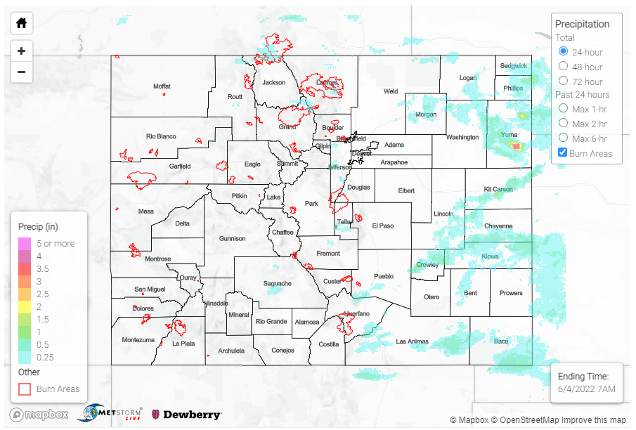
Click Here For Map Overview


The map below shows radar-estimated, rainfall gage-adjusted Quantitative Precipitation Estimates (QPE) across Colorado. The map is updated daily during the operational season (May 1 – Sep 30) by 11AM. The following six layers are currently available: 24-hour, 48-hour and 72-hour total precipitation, as well as maximum 1-hour, 2-hour and 6-hour precipitation over the past 24 hour period (to estimate where flash flooding may have occurred). The accumulation ending time is 7AM of the date shown in the bottom right corner. Also shown optionally are vulnerable fire burn areas (post 2012), which are updated throughout the season to include new, vulnerable burn areas. The home button in the top left corner resets the map to the original zoom.