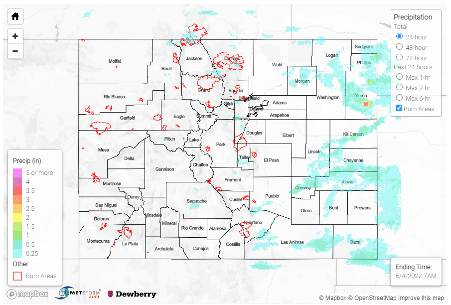
Issue Date: Saturday, June 4th, 2022
Issue Time: 10:35 AM MDT
Summary:
Precipitation kicked off in the early afternoon yesterday as widely scattered storms began to fire up along the eastern edges of the Front Range and Southeast Mountains, as well as the elevated Cheyenne, Palmer and Raton Ridges. A flood advisory, followed by a flash flood warning, was issued for Central Larimer County yesterday afternoon, including portions of the 2020 Cameron Peak burn scar, after thunderstorms producing heavy rain were indicated on radar. Rainfall totals this morning for the area were modest, T-0.25 inches of rain between CoCoRaHS observers and QPE. Thankfully, no flooding was reported on the burn scar, but the Cache La Poudre saw some moderate increases in streamflow at gauges west of and in Fort Collins.
As the afternoon progressed, all the ingredients came together for severe weather on the Eastern Plains as storms moved eastward off the high elevations – tapping into additional moisture and energy, which allowed for an increase in storm coverage and intensity. Yesterday really had it all, with multiple severe reports encompassing heavy rain, high winds, large hail, and tornadoes. In fact, over 30 severe thunderstorm warnings along were issued yesterday across the Eastern Plains, in addition to the many tornado and flood warnings!
Yuma County in particular was battered with severe weather, including the communities of Wray, Vernon and Idalia. A flash flood warning was issued for Southern Yuma County near Vernon, an area which was also impacted by severe thunderstorm warnings and tornado warnings. In addition to 0.25-1.00 inch hail across the area, a CoCoRaHS observer in Vernon reported a total of 4.06 inches of rain in 24-hours, along with the following remark:
over 3″ in 2 hours then a pause followed by additional rain of over 1″ in 3 hours
The 24-hour, 25-year Precipitation Frequency Estimates (PFE) from NOAA Atlas 14 for this area is 4.05 inches (just below what was observed). However, based on the observer remark, at the 2-hour duration this storm (over 3” in 2 hours) was much closer to the 2-hour 50-year PFE of 3.11 inches. This means this storm approached the 1 in 50-year ARI at 2-hours, or had just a 2% chance of occurrence in any given year! This cell of heavy rainfall can also be seen on the QPE map below, with over 4 inches of rain in central Yuma County. Nearby, another CoCoRaHS observer also reported nearly 2 inches of rain, and a bit to the north heavy rain (2.10 inches) was reported in Wauneta.
Lines of severe thunderstorms also extended southwest to northeast from Crowley to Kit Carson Counties, and west-east across Las Animas and Baca Counties yesterday. Some other notable rainfall totals from CoCoRAHS across the Eastern Plains include:
- 0.80 in Eads
- 0.70 in Burlington
- 0.65 in Holyoke
- 0.55 in Pritchett and Walsh
The western half of the state remained dry yesterday, though still blustery with a few 40-50 mph non-thunderstorm gusts reported across the Western Slopes and Grand Valley.
Despite all the excitement, there was no flooding reported yesterday. For precipitation estimates in your area, check out the map below.
