Issue Date: Tuesday, June 7th, 2022
Issue Time: 11:15 AM MDT
Summary:
Active weather continued across the state on Monday as another shortwave trough moving across the Intermountain West and Northern Rockies produced showers and storms over Colorado, including more severe weather. Convection developed yesterday afternoon over the high terrain along the Divide, before pushing off eastward into the adjacent plains where better moisture and instability was encountered.
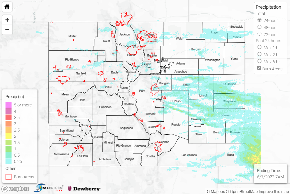
Precipitation amounts along the Urban Corridor were generally T-0.25”, with locally higher amounts of 0.25”-0.75” in the vicinity of Fort Collins and Colorado Springs. Storms over the Northern Mountains and northern Front Range prompted the Boulder WFO to issue Flood Advisories for both Grand and Larimer Counties, including the Cameron Peak and East Troublesome burn scars. The advisories were issued for minor flooding of small streams and low-lying/poor drainage areas; a station near Grand Lake measured just under 0.50” of rainfall in approximately 90 minutes. Thanks to fast flow aloft and storm motions of 35+ mph, no flooding was reported across either burn scar.
The heaviest precipitation yesterday occurred in a swath from the southern Urban Corridor across the Palmer Ridge and into the Southeast Plains. Healthy rainfall amounts of 0.50-1.50”, with locally higher amounts, were widespread across this corridor. Some noteworthy observations include:
• 1.71” 3 miles SW of Lamar
• 1.14” 1 mile NE of Peyton
• 0.92” at Lamar Municipal Airport
• 0.86” 3 miles NNE of Cheyenne Wells
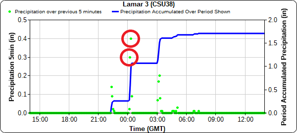
The town of Lamar was particularly hard hit, with 1.75” hail and an 82-mph thunderstorm wind gust recorded at Lamar Municipal Airport. The Pueblo WFO issued a Flash Flood Warning for west-central Prowers County including Lamar after local law enforcement reported “widespread flooded roads and other minor flooding.” An automated station 3 miles SW of Lamar reported 0.30” and 0.40” of rainfall in consecutive 5-minute periods, which translates to 0.70” in just 10 minutes!
Piles of hail all over Lamar. And the trees took a lot of damage. It dropped to 66° here. #cowx @NWSPueblo pic.twitter.com/n84Mha3tRh
— Deran Hall (@Deranphoto) June 7, 2022
In total, there were 16 hail reports within the patchwork of Severe Thunderstorm Warnings that blanketed the Southeast Plains yesterday. The severe weather threat waned by late evening, save for extreme southeastern Colorado. West of the Divide remained mainly dry, with only a trace to couple hundredths of an inch of rain reported, although several non-thunderstorm wind gusts approaching 50 mph were reported near Grand Junction and Glenwood Springs.
The only flooding reported statewide yesterday was in Lamar. For precipitation estimates in your area, check out the map below.

