SPM 09-23-2022: Continuation of Late-Season Rain for Southwest Portions of the State

Issue Date: Friday, September 23rd, 2022
Issue Time: 9:40 AM MDT

Summary:

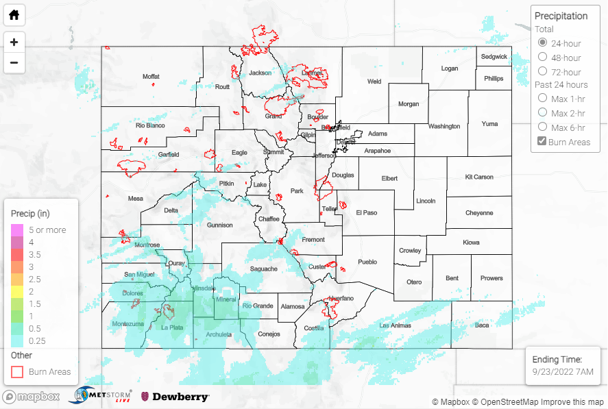
Rain continued across the state for the first half of the day on Thursday, albeit less widespread than on Wednesday; dry air began filtering in by late afternoon and clearing out the showers and storms. Many of the same regions experienced the highest precipitation totals, including the San Juan/Central Mountains and Southwest Slope, where QPE data suggests fairly widespread totals of 0.50-1.00”. These estimates are confirmed by rain gauge observations, including:

• 0.95” south of Durango
• 0.92” near Redmesa
• 0.75” near Durango
• 0.75” near Pagosa Springs
• 0.70” near Taylor Park Reservoir
• 0.68” near South Fork
• 0.50” north of Paonia
• 0.47” southwest of Uncompahgre Peak

Other regions that saw some of the heaviest precipitation totals include the Southeast Mountains southeastward across the Raton Ridge, where QPE data suggests similar totals of 0.50-1.00”. Rain gauge coverage is sparse, but these estimates are also confirmed by observations, including 0.91” south of Trinidad and 0.60” near Custer.

Elsewhere across the state, totals were light, with generally T-0.25” across the Grand Valley/Northwest Slope/Northern Mountains and T-0.15” across the Front Range/Urban Corridor/Palmer Ridge/Plains. On the backside of this departing system, dense fog was observed early this morning for many locations east of the Divide:

No flooding was reported yesterday. For precipitation estimates in our area, check out the map below. Remember, if you observe flooding in your area, you can use the “Report a Flood” page to make a flood report when you can safely do so.

Click Here For Map Overview

The map below shows radar-estimated, rainfall gage-adjusted Quantitative Precipitation Estimates (QPE) across Colorado. The map is updated daily during the operational season (May 1 – Sep 30) by 11AM. The following six layers are currently available: 24-hour, 48-hour and 72-hour total precipitation, as well as maximum 1-hour, 2-hour and 6-hour precipitation over the past 24 hour period (to estimate where flash flooding may have occurred). The accumulation ending time is 7AM of the date shown in the bottom right corner. Also shown optionally are vulnerable fire burn areas (post 2012), which are updated throughout the season to include new, vulnerable burn areas. The home button in the top left corner resets the map to the original zoom.

SPM 09-22-2022: Statewide, Late-Season Soaking Rain

Issue Date: Thursday, September 22nd, 2022
Issue Time: 11:00 AM MDT

Summary:

The plume of late-season subtropical moisture mentioned in yesterday’s SPM post combined with upper-level forcing to produce a widespread soaking rain over Colorado on the last full day of astronomical summer. In anticipation of this event, WFOs issued Flood Watches for most areas west of the Divide and along/south of I-70, although no warnings or advisories ended up being issued. The rain was more stratiform and steady in nature rather than convective and intense, which precluded flash flooding from occurring. Nonetheless, some locations did experience embedded convection and briefly heavier rainfall rates.

Several rivers and creeks in the mountains are running at all-time highs for this day of the year, including the Uncompahgre River near Ouray, Lincoln Creek near Aspen, the East Fork of the Eagle River near Climax, and Troublesome Creek near Troublesome, although no flooding has been reported.

QPE data suggests widespread amounts of 0.25-0.75” along and west of the Divide, with locally higher amounts of 1-2+” for the higher elevations of the Central Mountains and especially the San Juan Mountains/Southwest Slope. Notable rain gauge observations include:

• 2.22” west-northwest of Durago
• 1.92” south of Durango
• 1.57” southeast of Cortez
• 1.55” near Rico
• 1.48” near Mancos
• 1.23” near Cahone

East of the Divide across the Front Range and Urban Corridor, general amounts of 0.25-0.75” were observed, with the heaviest amounts closer to 0.75” reported in the Fort Collins vicinity. The eastern Northeast Plains experienced the heaviest rainfall of the entire state, with QPE data suggesting amounts of 1.5-2.5+” across the counties of Yuma, Logan, Sedgwick, and Phillips. Notable rain gauge observations here include:

• 1.93”, 1.71″, 1.70”, and 1.63” near Holyoke
• 1.48” near Idalia
• 1.40” near Fairfield
• 1.27” near Haxtun
• 1.23” near Crook
• 1.23” near Vernon

No flooding was reported yesterday. For precipitation estimates in our area, check out the map below. Remember, if you observe flooding in your area, you can use the “Report a Flood” page to make a flood report when you can safely do so.

Click Here For Map Overview

The map below shows radar-estimated, rainfall gage-adjusted Quantitative Precipitation Estimates (QPE) across Colorado. The map is updated daily during the operational season (May 1 – Sep 30) by 11AM. The following six layers are currently available: 24-hour, 48-hour and 72-hour total precipitation, as well as maximum 1-hour, 2-hour and 6-hour precipitation over the past 24 hour period (to estimate where flash flooding may have occurred). The accumulation ending time is 7AM of the date shown in the bottom right corner. Also shown optionally are vulnerable fire burn areas (post 2012), which are updated throughout the season to include new, vulnerable burn areas. The home button in the top left corner resets the map to the original zoom.

SPM 09-21-2022: Widespread Rain West of Divide, Early Morning Storms for Northern Northeast Plains

Issue Date: Wednesday, September 21st, 2022
Issue Time: 11:10 AM MDT

Summary:

A late-season plume of moisture began making its way into the region on Tuesday, producing fairly widespread showers and embedded storms for the western half of the state. From the Northern Mountains southward across the western slope and into the San Juans, precipitation amounts were generally in the 0.25-0.50” range. Some notable rain gauge observations include:

• 0.55” near Dolores
• 0.42” southwest of Durango
• 0.39” east of Bayfield
• 0.31” near Placerville
• 0.30” near Buford
• 0.29” and 0.28” near Glenwood Springs

East of the Divide saw a relatively dry Tuesday for most locations. However, an area of showers and storms did impact the northern half of the Northeast Plains before dawn this morning, mainly along and north of the I-76 corridor, producing the heaviest rainfall amounts of the past 24 hours. QPE data suggests a general swath of 0.25-0.50” along with localized amounts approaching and exceeding 1.00”, particularly across Logan, Sedgwick, and Phillips Counties. Rain gauge coverage is sparse, with the highest rain gauge observation in this region being 0.40” near Crook.

No flooding was reported yesterday. For precipitation estimates in our area, check out the map below. Remember, if you observe flooding in your area, you can use the “Report a Flood” page to make a flood report when you can safely do so.

Click Here For Map Overview

The map below shows radar-estimated, rainfall gage-adjusted Quantitative Precipitation Estimates (QPE) across Colorado. The map is updated daily during the operational season (May 1 – Sep 30) by 11AM. The following six layers are currently available: 24-hour, 48-hour and 72-hour total precipitation, as well as maximum 1-hour, 2-hour and 6-hour precipitation over the past 24 hour period (to estimate where flash flooding may have occurred). The accumulation ending time is 7AM of the date shown in the bottom right corner. Also shown optionally are vulnerable fire burn areas (post 2012), which are updated throughout the season to include new, vulnerable burn areas. The home button in the top left corner resets the map to the original zoom.

SPM 09-20-2022: Swath of Heavier Rain for Portions of Southeast Plains

Issue Date: Tuesday, September 20th, 2022
Issue Time: 11:00 AM MDT

Summary:

Monday featured mostly dry conditions across the state as the upper-level ridge continued to influence our weather, although three regions did observe some precipitation. The first region was the Grand Valley near Grand Junction, with very light amounts not exceeding 0.10”. The second region, which also saw very light rainfall amounts, was over and near the Palmer Ridge, with gauge observations again not exceeding 0.10”.

The last region, which experienced the heaviest precipitation, was a narrow swath from the Raton Ridge east-northeastward across the Southeast Plains and into Prowers County/western Kansas. Showers and storms that moved off the Ridge produced generally 0.25” or less, except across eastern Prowers where QPE data suggests amounts approaching and exceeding 1.00”. The highest rain gauge observation in Colorado associated with this precipitation was 0.30” from a CoCoRaHS observer near Holly; however, a few miles east of the border in Kansas saw observations of 1.16” and 0.95” near Coolidge.

No flooding was reported yesterday. For precipitation estimates in our area, check out the map below. Remember, if you observe flooding in your area, you can use the “Report a Flood” page to make a flood report when you can safely do so.

Click Here For Map Overview

The map below shows radar-estimated, rainfall gage-adjusted Quantitative Precipitation Estimates (QPE) across Colorado. The map is updated daily during the operational season (May 1 – Sep 30) by 11AM. The following six layers are currently available: 24-hour, 48-hour and 72-hour total precipitation, as well as maximum 1-hour, 2-hour and 6-hour precipitation over the past 24 hour period (to estimate where flash flooding may have occurred). The accumulation ending time is 7AM of the date shown in the bottom right corner. Also shown optionally are vulnerable fire burn areas (post 2012), which are updated throughout the season to include new, vulnerable burn areas. The home button in the top left corner resets the map to the original zoom.