Issue Date: Thursday, September 22nd, 2022
Issue Time: 11:00 AM MDT
Summary:
The plume of late-season subtropical moisture mentioned in yesterday’s SPM post combined with upper-level forcing to produce a widespread soaking rain over Colorado on the last full day of astronomical summer. In anticipation of this event, WFOs issued Flood Watches for most areas west of the Divide and along/south of I-70, although no warnings or advisories ended up being issued. The rain was more stratiform and steady in nature rather than convective and intense, which precluded flash flooding from occurring. Nonetheless, some locations did experience embedded convection and briefly heavier rainfall rates.
Several rivers and creeks in the mountains are running at all-time highs for this day of the year, including the Uncompahgre River near Ouray, Lincoln Creek near Aspen, the East Fork of the Eagle River near Climax, and Troublesome Creek near Troublesome, although no flooding has been reported.
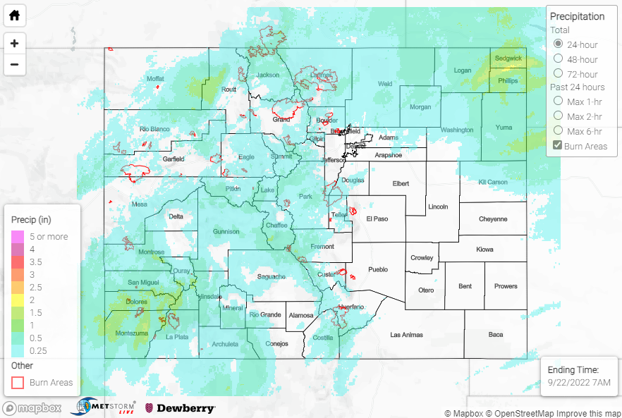
QPE data suggests widespread amounts of 0.25-0.75” along and west of the Divide, with locally higher amounts of 1-2+” for the higher elevations of the Central Mountains and especially the San Juan Mountains/Southwest Slope. Notable rain gauge observations include:
• 2.22” west-northwest of Durago
• 1.92” south of Durango
• 1.57” southeast of Cortez
• 1.55” near Rico
• 1.48” near Mancos
• 1.23” near Cahone
East of the Divide across the Front Range and Urban Corridor, general amounts of 0.25-0.75” were observed, with the heaviest amounts closer to 0.75” reported in the Fort Collins vicinity. The eastern Northeast Plains experienced the heaviest rainfall of the entire state, with QPE data suggesting amounts of 1.5-2.5+” across the counties of Yuma, Logan, Sedgwick, and Phillips. Notable rain gauge observations here include:
• 1.93”, 1.71″, 1.70”, and 1.63” near Holyoke
• 1.48” near Idalia
• 1.40” near Fairfield
• 1.27” near Haxtun
• 1.23” near Crook
• 1.23” near Vernon
No flooding was reported yesterday. For precipitation estimates in our area, check out the map below. Remember, if you observe flooding in your area, you can use the “Report a Flood” page to make a flood report when you can safely do so.
Click Here For Map Overview