SPM 06-19-2022 – Subtropical Moisture Brings Another Day Of Scattered Rain Showers

Issue Date: Sunday, June 19th, 2022
Issue Time: 11:45 AM MDT

Summary:

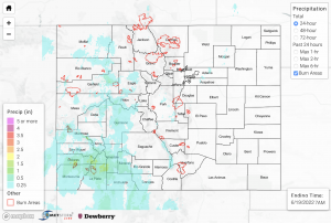
Yesterday’s ongoing subtropical moisture surge brought another round of scattered rain showers and thunderstorms across much western Colorado yesterday. While instability in parts of western Colorado reached up to 1500 J/kg of CAPE and PW values increased into the 0.8-inch range, the relatively quick steering flow kept storms moving quickly and helped minimize the flood threat. Still, periods of heavy rainfall occurred primarily over the San Juan Mountains and the San Luis Valley in afternoon and evening, with a few showers lingering into the overnight hours. Additionally, briefly heavy rainfall occurred over portions of the higher elevations of the Central Mountains in the afternoon, while a briefly intense storm occurred in Morgan County in the Northeast Plains with locally heavy rainfall there as well. There were no flood warnings or advisories issued yesterday, and there were no flood reports as of the time of this posting.

The highest rain totals recorded for the day were as follows:

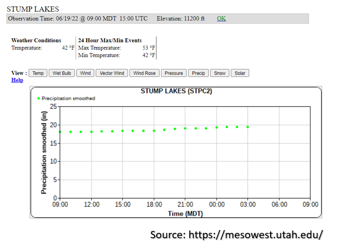
– 1.6 inches recorded by a SNOTEL gage at Stump Lakes at 11,200 feet northeast of Durango (shown in the image below)
– 1.24 inches recorded by a CoCoRaHS station 7 miles north of Bayfield
– 1.1 inches measured about 6 miles south of Pagosa Springs

In association with the briefly intense heavy rainfall that occurred over Morgan County, a CoCoRaHS station outside of Fort Morgan recorded 0.55 inches of rainfall for the day. Additionally, there were several wind gusts reported yesterday, with the strongest being measured at 62 mph in Garfield County.

At this time there are no rivers in flood stage, but rises have already begun and should continue over the next 24-hours with another day of rain ahead and saturated soils. This is especially true over the San Juan and San Luis Valley areas where 48-hour totals up to 1.5 to 2 inches have fallen.
Click Here For Map Overview

The map below shows radar-estimated, rainfall gage-adjusted Quantitative Precipitation Estimates (QPE) across Colorado. The map is updated daily during the operational season (May 1 – Sep 30) by 11AM. The following six layers are currently available: 24-hour, 48-hour and 72-hour total precipitation, as well as maximum 1-hour, 2-hour and 6-hour precipitation over the past 24 hour period (to estimate where flash flooding may have occurred). The 24-hour, 48-hour and 72-hour total precipitation contain bias corrections that are not disaggregated into the hourly estimates, so there will likely be some differences. The accumulation ending time is 7AM of the date shown in the bottom right corner. Also shown optionally are vulnerable fire burn areas (post 2012), which are updated throughout the season to include new, vulnerable burn areas. The home button in the top left corner resets the map to the original zoom.

SPM 06-18-2022: Subtropical Moisture Surges Into Western Colorado

Issue Date: Saturday, June 18th, 2022
Issue Time: 9:45 AM MDT

Summary:

A steady plume of northward-moving subtropical moisture brought numerous rain showers and thunderstorms across western Colorado yesterday afternoon through the overnight hours. NWS Pueblo issued a late-morning flash flood warning over the Spring Creek burn scar, and their 12:01pm update estimated rain rates of 0.5 to 1 inch per hour over the burn scar. This flash flood warning was allowed to expire at 2:45pm as the heavy rainfall moved out of the area, and no flood reports were associated with the storm.

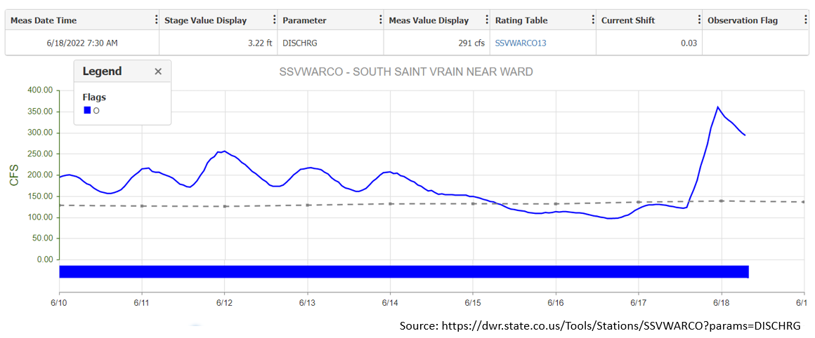
More notably, heavy rainfall also occurred just to the northwest of Nederland in the mid-afternoon, where a high elevation SNOTEL gage recorded a total of 1.2 inches of rainfall over the Indian Peaks. In the Allenspark area, 0.65 inches and 0.75 inches of precipitation were recorded by personal weather stations. A notable response to this heavy rainfall was observed by the South Saint Vrain river gage near Ward, which measured a noteworthy spike in streamflow at 11pm last night, as shown by the streamflow graph below. This peak in river flow even exceeded its snowmelt peak from earlier this week!

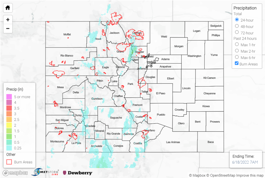
There was some disagreement in QPE estimations, but it appears possible that up to 1.5 to 2 inches of QPE occurred over a 2 to 3 hour period in the vicinity of the heaviest rainfall northwest of Nederland yesterday afternoon. Elsewhere across the western half of the state, QPE was more along the 0.25 to 0.5 inch range. Additionally, several wind reports were made across western Colorado in the afternoon. The highest wind gusts of 60mph and 66mph were recorded in Pitkin County at 1:49pm and 2:49pm, respectively.

Click Here For Map Overview

The map below shows radar-estimated, rainfall gage-adjusted Quantitative Precipitation Estimates (QPE) across Colorado. The map is updated daily during the operational season (May 1 – Sep 30) by 11AM. The following six layers are currently available: 24-hour, 48-hour and 72-hour total precipitation, as well as maximum 1-hour, 2-hour and 6-hour precipitation over the past 24 hour period (to estimate where flash flooding may have occurred). The 24-hour, 48-hour and 72-hour total precipitation contain bias corrections that are not disaggregated into the hourly estimates, so there will likely be some differences. The accumulation ending time is 7AM of the date shown in the bottom right corner. Also shown optionally are vulnerable fire burn areas (post 2012), which are updated throughout the season to include new, vulnerable burn areas. The home button in the top left corner resets the map to the original zoom.

SPM 06-17-2022: Heat Continues, Thunderstorms and Hail for Northern Colorado

Issue Date: Friday, June 17th, 2022
Issue Time: 9:45 AM MDT

Summary:

The majority of the state continued to be precipitation-free, with little to report aside from the high temperatures and a report of non-thunderstorm wind gusts of 55 mph at the Cortez Municipal Airport. However, the northern Urban Corridor region saw a fair amount of rainfall and thunderstorms, and the Southeast Plains had some storm activity as well.

The northern Front Range and Urban Corridor saw the bulk of the action yesterday. Two severe thunderstorm warnings were issued between Greeley and Brighton last night, along with multiple reports of hail and high winds. There were 7 reports of hail in this area – most described 1” hail, but a few public reports in Hudson mentioned up to 1.25″-1.5”. Wind gusts were reported up to 82 mph. Rainfall in this area varied depending on location but ranged from 0” and trace amounts up to over half an inch. Even closer to the mountains, northeast of Longmont, received up to 0.34” of rainfall and had some small hail reports as well. The highest precipitation observations from yesterday include:

– Up to 0.53” in Greeley
– 0.66” and 0.62” in Loveland
– 0.56″ in Kersey (one CoCoRaHS reporter noted “intense lightning”)

That lightning, associated with yesterday’s thunderstorms along I-25, seemed to capture the attention of many – see below for an excellent shot.


Down in the Southern Plains near Lamar, another severe thunderstorm warning was issued in the late afternoon, with rainfall coming in at 0.21” and 0.39”. The brief storm was accompanied by a report of hail that was 0.75” in size, and 55 mph wind gusts.

There was no flooding reported yesterday. For precipitation estimates in your area, check out the map below.

Click Here For Map Overview

The map below shows radar-estimated, rainfall gage-adjusted Quantitative Precipitation Estimates (QPE) across Colorado. The map is updated daily during the operational season (May 1 – Sep 30) by 11AM. The following six layers are currently available: 24-hour, 48-hour and 72-hour total precipitation, as well as maximum 1-hour, 2-hour and 6-hour precipitation over the past 24 hour period (to estimate where flash flooding may have occurred). The accumulation ending time is 7AM of the date shown in the bottom right corner. Also shown optionally are vulnerable fire burn areas (post 2012), which are updated throughout the season to include new, vulnerable burn areas. The home button in the top left corner resets the map to the original zoom.

SPM 06-16-2022: Calm and Sunny

Issue Date: Thursday, June 16th, 2022
Issue Time: 9:30 AM MDT

Summary:

Yesterday was fairly uneventful- almost no precipitation was reported, save for a few reports in the northeastern corner of the state, and temperatures were still a bit cooler than the heat from last weekend. Scarce reports of 0.01, 0.03 and 0.12 inches in Philips County were the extent of the rainfall for the state; along with an absence of any severe weather or advisories, this lead to a relatively calm day.

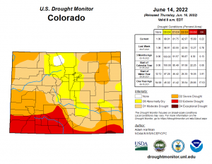
The U.S. Drought Monitor has released an updated report for this week. Positively, the area of exceptional drought has decreased from 0.79% to 0.23%, and severe drought has also dropped slightly from 83.55% to 81.55%. Areas in the extreme drought category increased approximately 2.6%, however. Across the board, these changes were still very minor adjustments from the previous week’s conditions.

There was no flooding reported yesterday. For precipitation estimates in your area, check out the map below.

Click Here For Map Overview

The map below shows radar-estimated, rainfall gage-adjusted Quantitative Precipitation Estimates (QPE) across Colorado. The map is updated daily during the operational season (May 1 – Sep 30) by 11AM. The following six layers are currently available: 24-hour, 48-hour and 72-hour total precipitation, as well as maximum 1-hour, 2-hour and 6-hour precipitation over the past 24 hour period (to estimate where flash flooding may have occurred). The accumulation ending time is 7AM of the date shown in the bottom right corner. Also shown optionally are vulnerable fire burn areas (post 2012), which are updated throughout the season to include new, vulnerable burn areas. The home button in the top left corner resets the map to the original zoom.