SPM 06-27-2022: Storms Continue, Debris Flow Closes CO 125

Issue Date: Monday, June 27th, 2022
Issue Time: 11:15 AM MDT

Summary:

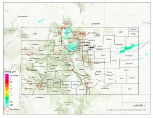
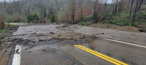
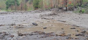
Another day of rain meant an eventful day for Colorado, the biggest news being a debris flow that occurred yesterday afternoon in Grand County, north of Granby. This debris flow occurred on the eastern portion of the East Troublesome burn scar, with precipitation totals near the debris flow area of up to 0.46”. It blocked off a section of CO 125- between County Road 54 and US 40 (Willowcreek Pass) from Mile Point 30.5 to Mile Point 0.01 is now closed. Via Grand County, there is no expected time for opening. Pictures below via the Grand County Sherriff’s Office show the debris flow in detail, and you can even see the burn scar behind it!

As far as rainfall goes, the heaviest precipitation occurred from the Southwest Slope over to the Southeast Mountains- totals of up to 1.61” across the southwest, particularly near Pagosa Springs and Durango. Most rainfall occurred due to storms in the late afternoon and evening. A flood advisory was issued for a large section near the western border of the state. While no flooding was reported within the advisory boundary, one CoCoRaHS reporter near the southern flood advisory boundary noted “some heavy field flooding on my 5 acres.” Moving eastward, totals south of Pueblo and in surrounding areas were anywhere from 0.2”-1.0”. East of Pueblo County in the Southeast Plains saw precipitation from 0” – 0.1” but up to 0.27” near Pinion Canyon.

The Northwest Slope and farther south in Grand Junction stayed relatively dry. However, east of Grand Junction saw some heavier totals in the mountains- 0.5” in Montrose, up to 1.0” near Salida, 0.68” in Crested Butte, to name a few. 0.25” hail was reported near Ridgway, Cimarron, and New Castle.

On the other side of the mountains, Colorado Springs received up to 0.5” observations, but rain was lighter and more consistent throughout the day than other parts of the state. Denver received only trace amounts of rainfall. Front Range totals to the east of the Urban Corridor, from southeast of Denver and farther north, were lighter as well, up to 0.3”-0.4” higher in the mountains but only a few hundredths of an inch at lower foothill elevations. Some small hail was reported in Rocky Mountain National Park along with the light showers. Last, a flood advisory was issued for a part of Larimer County over the Cameron Peak burn scar yesterday afternoon, but no flooding was reported for that area.

Note: The Grand Junction radar is down for maintenance. This will impact the accuracy of QPE, especially in the southwestern portion of the state.
Click Here For Map Overview

The map below shows radar-estimated, rainfall gage-adjusted Quantitative Precipitation Estimates (QPE) across Colorado. The map is updated daily during the operational season (May 1 – Sep 30) by 11AM. The following six layers are currently available: 24-hour, 48-hour and 72-hour total precipitation, as well as maximum 1-hour, 2-hour and 6-hour precipitation over the past 24 hour period (to estimate where flash flooding may have occurred). The accumulation ending time is 7AM of the date shown in the bottom right corner. Also shown optionally are vulnerable fire burn areas (post 2012), which are updated throughout the season to include new, vulnerable burn areas. The home button in the top left corner resets the map to the original zoom.

SPM 06-26-2022: Storms for Central and Southern Colorado

Issue Date: Sunday, June 26th, 2022
Issue Time: 9:50 AM MDT

Summary:

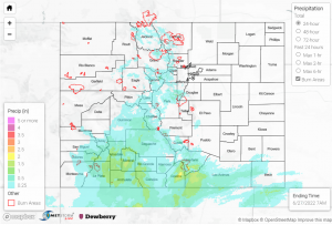
Yesterday we saw much-needed rainfall in many areas, mostly concentrated along the Urban Corridor and in the south-central portion of the state. Colorado Springs and the mountains to the west of the city seemed to have the heaviest precipitation- see the totals below for some notable observations. There was a flash flood warning issued yesterday evening for Chaffee County, but thankfully no flooding was reported.

-1.59” in Salida, with remarks of powerful rain for several hours beginning in the evening- this was southwest of the flash flood warning area
-0.64” in Hartsel
-1.16” reported in Colorado Springs, with many observations from the area of 0.5”-1”
-Pikes Peak received some snow!

For the Southeast Mountains and San Luis Valley, most observations were between 0.1” and 0.3”. Some areas received much higher amounts, including 0.53” in Canon City and 0.69” in Aguilar. Farther out west, Pagosa Springs received up to 0.38”, but the Southwestern Slope and mountains to the north and northwest only saw up to about 0.1” in most places from intermittent, light showers. Out east, the Southern Plains generally received 0.1”-0.4″.

The Denver area did not receive much rainfall at all yesterday, only up to a few hundredths of an inch. Northern Colorado received healthier totals. 0.24” in Greeley, 0.27” in Loveland, and 0.19” were the highest observations across the area, from seemingly calmer showers in the late afternoon and evening.

A few stream gages in Colorado Springs and south of the city area reporting high levels, but all are declining and none are near flood stage. There was no flooding reported yesterday. For precipitation estimates in your area, check out the map below.

Note: The Grand Junction radar is down for maintenance. This will impact the accuracy of QPE, especially in the southwestern portion of the state.
Click Here For Map Overview

The map below shows radar-estimated, rainfall gage-adjusted Quantitative Precipitation Estimates (QPE) across Colorado. The map is updated daily during the operational season (May 1 – Sep 30) by 11AM. The following six layers are currently available: 24-hour, 48-hour and 72-hour total precipitation, as well as maximum 1-hour, 2-hour and 6-hour precipitation over the past 24 hour period (to estimate where flash flooding may have occurred). The accumulation ending time is 7AM of the date shown in the bottom right corner. Also shown optionally are vulnerable fire burn areas (post 2012), which are updated throughout the season to include new, vulnerable burn areas. The home button in the top left corner resets the map to the original zoom.

SPM 06-25-2022: Another Day of State-Wide Showers

Issue Date: Saturday, June 25th, 2022
Issue Time: 10:25 AM MDT

Summary:

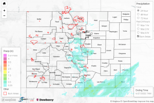
Yesterday we saw scattered showers across Colorado, more widespread across Colorado than Thursday. In the west, there were high thunderstorm gusts right on the border of Utah in Dove Creek, up to 51 mph. There were also winds recorded up to 58 mph in Rifle- both of these were observed in the afternoon yesterday. Across the western mountains and southwest, rainfall occurred generally in the late morning- 0.24” in Placerville with similar totals to the west, up to 0.22” near Durango, 0.48” in El Jebel and 0.33” near Carbondale. Some areas, such as Placerville, had reports of small hail as well.

The Front Range saw up to 0.32” west of Denver in the mountains, while most precipitation totals along the I-25 corridor between Denver and Pueblo were between 0” and a few hundredths of an inch. While no flooding was reported over any of the mountain burn scars east of the Urban Corridor, one CoCoRaHS reporter did note minor street flooding in their neighborhood in Boulder. There was also some small hail reported in this area.

Lastly, the central plains near the Kansas border saw storms in the late afternoon and evening hours. Three thunderstorm warnings, overlapping an area that spanned into Kansas, were issued between 4-8 p.m. yesterday. Associated with these were a handful of hail reports- pea to a half-inch size in Bethune, along with high winds. At the south of the storms in Cheyenne Wells, dime to nickel sized hail was observed (less than 1″ across). Burlington received the heaviest totals- 0.95” and 0.44” among others.

For precipitation estimates in your area, check out the map below.

Note: The Grand Junction radar is still down for maintenance. This will impact the accuracy of QPE, especially in the southwestern portion of the state.
Click Here For Map Overview

The map below shows radar-estimated, rainfall gage-adjusted Quantitative Precipitation Estimates (QPE) across Colorado. The map is updated daily during the operational season (May 1 – Sep 30) by 11AM. The following six layers are currently available: 24-hour, 48-hour and 72-hour total precipitation, as well as maximum 1-hour, 2-hour and 6-hour precipitation over the past 24 hour period (to estimate where flash flooding may have occurred). The accumulation ending time is 7AM of the date shown in the bottom right corner. Also shown optionally are vulnerable fire burn areas (post 2012), which are updated throughout the season to include new, vulnerable burn areas. The home button in the top left corner resets the map to the original zoom.

SPM 06-24-2022: Significant Storms for the West, Dry in the East

Issue Date: Friday, June 24th, 2022
Issue Time: 11:15 AM MDT

Summary:

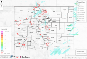
Yesterday was eventful for Western Colorado, as west of the Divide saw significant rain and severe weather from north to south. In the southwest, precipitation totals included 0.62” west of Durango, and 0.77” in Ignacio close to the southern border. Thunderstorms moved through the area in the afternoon and into the later evening, bringing heavier rainfall and wind gusts of up to 49 mph.
Some other significant precipitation totals across the state include:

– 1.26” in Winter Park
-0.54” in Carbondale
-0.71” in Hotchkiss
-0.83” in Del Norte
-1.44” in just about an hour, across the border in Monticello, UT!

Grand Junction was a hub of activity yesterday, as well. Storms brought up to 0.46” over the evening in two short bursts. CoCoRaHS reports included observations of “small and sporadic hail”, and several others mentioned a good amount of thunder and lightning with the intermittent thunderstorms. Wind gusts of around 46 mph were observed along with these storms in Grand Junction and near Rifle to the east.

Additionally, three flood advisories for minor flooding (small streams, creeks, and arroyos) were issued throughout the afternoon and into the evening in areas surrounding Grand Junction to the north and south. One of the flood advisories for Mesa and Garfield counties was issued over the Pine Gulch burn scar, north of Grand Junction- however, no flooding was reported in any of the advisory areas. While none of the streams in the area are in flood stage, discharge certainly increased dramatically for many. The hydrograph below shows an increase of almost 300 cfs on the Dolores River near Gateway.

Outside of the Southwest Slope and around Grand Valley, the Central Mountains and Front Range received a a similar evening of numerous thunderstorms, as well, in many locations up to over 0.40”. East of the mountains into the I-25 corridor saw some slight trace amounts and was dry, although Pueblo saw up to 0.18” from some intermittent showers, including a brief thunderstorm and high winds. The Northern Plains also had some rainfall,  up to 1.5” in Yuma County.

There was no flooding reported yesterday. For precipitation estimates in your area, check out the map below.

Note: The Grand Junction radar is down for maintenance. This will impact the accuracy of QPE, especially in the southwestern portion of the state.
Click Here For Map Overview

The map below shows radar-estimated, rainfall gage-adjusted Quantitative Precipitation Estimates (QPE) across Colorado. The map is updated daily during the operational season (May 1 – Sep 30) by 11AM. The following six layers are currently available: 24-hour, 48-hour and 72-hour total precipitation, as well as maximum 1-hour, 2-hour and 6-hour precipitation over the past 24 hour period (to estimate where flash flooding may have occurred). The accumulation ending time is 7AM of the date shown in the bottom right corner. Also shown optionally are vulnerable fire burn areas (post 2012), which are updated throughout the season to include new, vulnerable burn areas. The home button in the top left corner resets the map to the original zoom.